Rockaway Beach, Missouri

Last updated

Rockaway Beach, Missouri
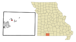
Taney County Missouri Incorporated and Unincorporated areas Rockaway Beach Highlighted.svg
Location of Rockaway Beach, Missouri
Coordinates: 36°42′07″N93°09′43″W / 36.70194°N 93.16194°W / 36.70194; -93.16194 [1]
Country United States
State Missouri
County Taney
Government
  MayorJim Harriger [2]
Area
[3]
  Total0.76 sq mi (1.97 km2)
  Land0.63 sq mi (1.63 km2)
  Water0.13 sq mi (0.33 km2)
Elevation
[1]
843 ft (257 m)
Population
 (2020)
  Total829
  Density1,313.79/sq mi (507.10/km2)
Time zone UTC-6 (Central (CST))
  Summer (DST) UTC-5 (CDT)
ZIP code
65740
Area code 417
FIPS code 29-62570 [4]
GNIS feature ID2396404 [1]
Website www.rockawaybeach-mo.org

Rockaway Beach is a city in Taney County, Missouri, United States. The population was 829 at the 2020 census. [5] It lies on the shoreline of the White River.

Contents

Rockaway Beach is part of the Branson, Missouri Micropolitan Statistical Area.

History

Rockaway Beach had its start when a developer bought property on what was speculated to become the shore of Lake Taneycomo. [6] The name most likely is a transfer from Rockaway Beach, New York. [7] A post office called Rockaway Beach has been in operation since 1933. [8]

Geography

Rockaway Beach is located on the north shore of Lake Taneycomo and the White River. Forsyth is approximately three miles to the southeast on Missouri Route 176. [9]

According to the United States Census Bureau, the city has a total area of 0.69 square miles (1.79 km2), of which 0.61 square miles (1.58 km2) is land and 0.08 square miles (0.21 km2) is water. [10]

Demographics

Historical population
CensusPop.Note
1960 177
1970 19510.2%
1980 29249.7%
1990 275−5.8%
2000 577109.8%
2010 84145.8%
2020 829−1.4%
U.S. Decennial Census [11]

2010 census

As of the census [12] of 2010, there were 841 people, 365 households, and 222 families living in the city. The population density was 1,378.7 inhabitants per square mile (532.3/km2). There were 528 housing units at an average density of 865.6 per square mile (334.2/km2). The racial makeup of the city was 96.1% White, 0.7% African American, 1.0% Native American, 0.6% Pacific Islander, 0.4% from other races, and 1.3% from two or more races. Hispanic or Latino of any race were 2.0% of the population.

There were 365 households, of which 23.3% had children under the age of 18 living with them, 44.1% were married couples living together, 11.0% had a female householder with no husband present, 5.8% had a male householder with no wife present, and 39.2% were non-families. 29.9% of all households were made up of individuals, and 8.8% had someone living alone who was 65 years of age or older. The average household size was 2.24 and the average family size was 2.78.

The median age in the city was 45.3 years. 21% of residents were under the age of 18; 6.6% were between the ages of 18 and 24; 22% were from 25 to 44; 32% were from 45 to 64; and 18.4% were 65 years of age or older. The gender makeup of the city was 49.6% male and 50.4% female.

2000 census

As of the census [4] of 2000, there were 577 people, 274 households, and 169 families living in the city. The population density was 1,037.1 inhabitants per square mile (400.4/km2). There were 366 housing units at an average density of 657.8 per square mile (254.0/km2). The racial makeup of the city was 96.36% White, 0.17% African American, 0.87% Native American, 0.52% from other races, and 2.08% from two or more races. Hispanic or Latino of any race were 1.56% of the population.

There were 274 households, out of which 22.3% had children under the age of 18 living with them, 53.6% were married couples living together, 5.8% had a female householder with no husband present, and 38.0% were non-families. 31.0% of all households were made up of individuals, and 10.9% had someone living alone who was 65 years of age or older. The average household size was 2.11 and the average family size was 2.64.

In the city the population was spread out, with 18.0% under the age of 18, 4.2% from 18 to 24, 24.1% from 25 to 44, 30.7% from 45 to 64, and 23.1% who were 65 years of age or older. The median age was 47 years. For every 100 females, there were 100.3 males. For every 100 females age 18 and over, there were 93.9 males.

The median income for a household in the city was $33,359, and the median income for a family was $39,063. Males had a median income of $21,375 versus $20,833 for females. The per capita income for the city was $17,589. About 4.8% of families and 8.7% of the population were below the poverty line, including 6.7% of those under age 18 and 9.2% of those age 65 or over.
Related Research Articles

<span class="mw-page-title-main">Taney County, Missouri</span> County in Missouri, United States

Taney County is a county in the southwestern portion of the U.S. state of Missouri. As of the 2020 census, the population was 56,066. Its county seat is Forsyth. It is included in the Branson, Missouri, Micropolitan Statistical Area.

<span class="mw-page-title-main">Freeman, Missouri</span> City in Missouri, United States

Freeman is a city in Cass County, Missouri, United States. The population was 482 at the 2010 census. It is part of the Kansas City metropolitan area.

<span class="mw-page-title-main">Craig, Missouri</span> City in Missouri, United States

Craig is a city in Holt County, Missouri, United States. The population was 105 at the 2020 census.

<span class="mw-page-title-main">Laurie, Missouri</span> City in Missouri, United States

Laurie is a city in southern Morgan and northern Camden counties, Missouri, United States. The population was 945 at the 2010 census.

<span class="mw-page-title-main">Green Ridge, Missouri</span> City in Missouri, United States

Green Ridge is a city located along Route 127 in Pettis County, Missouri, United States. The population was 476 at the 2010 census.

<span class="mw-page-title-main">La Monte, Missouri</span> City in Missouri, United States

La Monte is a city in Pettis County, Missouri, United States. The population was 1,140 at the 2010 census.

<span class="mw-page-title-main">Pleasant Hope, Missouri</span> City in Missouri, United States

Pleasant Hope is a city in Polk County, Missouri, United States. The population was 614 at the 2010 census. It is part of the Springfield, Missouri Metropolitan Statistical Area.

<span class="mw-page-title-main">Shelbyville, Missouri</span> City in Missouri, United States

Shelbyville is a city in Shelby County, Missouri, United States. The population was 518 at the 2020 census. It is the county seat of Shelby County.

<span class="mw-page-title-main">Bella Villa, Missouri</span> City in Missouri, United States

Bella Villa is a city in St. Louis County, Missouri, in the United States. As of the 2010 census, the city population was 729.

<span class="mw-page-title-main">Greendale, Missouri</span> City in Missouri, United States

Greendale is a city in St. Louis County, Missouri, United States. The population was 651 at the 2010 census.

<span class="mw-page-title-main">Lakeshire, Missouri</span> City in Missouri, United States

Lakeshire is a city in St. Louis County, Missouri, United States. The population was 1,432 at the 2010 census.

<span class="mw-page-title-main">Pasadena Hills, Missouri</span> City in Missouri, United States

Pasadena Hills is a city in St. Louis County, Missouri, United States. The population was 930 at the 2010 census. The entire city is listed on the National Register of Historic Places.

<span class="mw-page-title-main">Bull Creek, Missouri</span> Village in Missouri, United States

Bull Creek is a village in northwest Taney County, Missouri, United States. The population was 426 at the 2020 census. It is part of the Branson, Missouri Micropolitan Statistical Area.

<span class="mw-page-title-main">Merriam Woods, Missouri</span> City in Missouri, United States

Merriam Woods is a city in Taney County, Missouri, United States. The population was 2,006 at the 2020 census. It is part of the Branson, Missouri Micropolitan Statistical Area.

<span class="mw-page-title-main">Houston Lake, Missouri</span> City in Missouri, United States

Houston Lake is a city in Platte County, Missouri, and is part of the Kansas City metropolitan area within the United States. The population was 235 at the 2010 census.

<span class="mw-page-title-main">Forsyth, Missouri</span> City in Missouri, United States

Forsyth is a city in Taney County, Missouri, United States. The population was 2,730 at the 2020 census. It is the county seat of Taney County. The town is part of the Branson, Missouri Micropolitan Statistical Area. Forsyth is located on Lake Taneycomo on U.S. Route 160.

<span class="mw-page-title-main">White Meadow Lake, New Jersey</span> Populated place in Morris County, New Jersey, US

White Meadow Lake is an unincorporated community and census-designated place (CDP) located within Rockaway Township, in Morris County, in the U.S. state of New Jersey. As of the 2010 United States Census, the CDP's population was 8,836.

<span class="mw-page-title-main">Rockaway Beach, Oregon</span> City in Oregon, United States

Rockaway Beach is a city in Tillamook County, Oregon, United States. The population was 1,312 at the 2010 census.

<span class="mw-page-title-main">Osage Beach, Missouri</span> City in Missouri, United States

Osage Beach is a city in Camden and Miller counties in the U.S. state of Missouri, near the Lake of the Ozarks. Most of the city is in Camden County, while a small eastern sliver is in Miller County. The population was 4,351 at the 2010 census.

Sunrise Beach is a village in Camden and Morgan counties in the U.S. state of Missouri. The population was 431 at the 2010 census.

References

  1. 1 2 3 U.S. Geological Survey Geographic Names Information System: Rockaway Beach, Missouri
  2. "New Rockaway Beach mayor ask residents to volunteer".
  3. "ArcGIS REST Services Directory". United States Census Bureau. Retrieved August 28, 2022.
  4. 1 2 "U.S. Census website". United States Census Bureau . Retrieved January 31, 2008.
  5. "Explore Census Data". data.census.gov. Retrieved December 6, 2021.
  6. Earngey, Bill (1995). Missouri Roadsides: The Traveler's Companion. University of Missouri Press. p. 26. ISBN   9780826210210.
  7. "Taney County Place Names, 1928–1945". The State Historical Society of Missouri. Archived from the original on June 24, 2016. Retrieved December 27, 2016.
  8. "Post Offices". Jim Forte Postal History. Retrieved December 27, 2016.
  9. Branson, MO, 7.5 Minute Topographic Quadrangle, USGS, 1985
  10. "US Gazetteer files 2010". United States Census Bureau. Archived from the original on January 25, 2012. Retrieved July 8, 2012.
  11. "Census of Population and Housing". Census.gov. Retrieved June 4, 2015.
  12. "U.S. Census website". United States Census Bureau . Retrieved July 8, 2012.