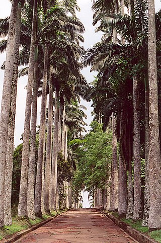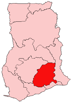
Aburi is a town in the Akuapim South Municipal District of the Eastern Region of south Ghana famous for the Aburi Botanical Gardens and the Odwira festival. Aburi has a population of 18,701 people as of 2013.

Kwahu or Kwawu is an area and group of people that live in Ghana and are part of the Twi-speaking Akan group. The region has been dubbed Asaase Aban, or the Natural Fortress, given its position as the highest habitable elevation in the country. Kwahu lies in the Eastern Region of Ghana, on the west shore of Lake Volta. The Kwahus share the Eastern Region with the Akyem and Akuapem, as well as the Adangbe-Krobos. Among Kwahu lands, a significant migrant population works as traders, farm-hands, fisherfolk, and caretakers in the fertile waterfront 'melting pot' of Afram plains. These migrants are mostly from the Northern and Volta Regions, as well as, some indigenous Guans from the bordering Oti and Brong-Ahafo regions live in the Afram Plains area. Kwahus are traditionally known to be wealthy traders, owning a significant number of businesses and industries in Ghana.

The Akyem are an Akan people. The term Akyem is used to describe a group of four states: Asante Akyem, Akyem Abuakwa, Akyem Kotoku, and Akyem Bosome. These nations are located primarily in the eastern region in south Ghana. The term is also used to describe the general area where the Akyem ethnic group clusters. The Akyem ethnic group make up between 3-4 percent of Ghana's population depending on how one defines the group and are very prominent in all aspects of Ghanaian life. The Akyem are a matrilineal people. The history of this ethnic group is that of brave warriors who managed to create a thriving often influential and relatively independent state within modern-day Ghana. When one talks of Ghanaian history, there is often mention of The Big Six. These were six individuals who played a big role in the independence of Ghana. Of the big six, people of Akyem descent made up the majority.
Akwamu was a state set up by the Akwamu people in present-day Ghana. After migrating from Bono state, the Akan founders of Akwamu settled in Twifo-Heman. The Akwamu led an expansionist empire in the 17th and 18th centuries. At the peak of their empire, Akwamu extended 400 kilometres (250 mi) along the coast from Ouidah, Benin in the East to Winneba, Ghana, in the West.

Akropong is a town in South Ghana and is the capital of the Akuapim North District, a district in the Eastern Region of South Ghana. This town is known for producing snails and palm oil. Akropong has a 2013 settlement population of 13,785 people.
Adukrom is a town in the Okere District Assembly in the Eastern Region of Ghana. It shares borders with Awukugua Akuapem where Okomfo anokye was born The town is known for the Nifahene Stool of Akuapem and the capital of Okere District and situated on the Togo Atakora hills on the main Ho-Koforidua main trunk road in the northern part of Akuapem.
The Odwira festival is celebrated by the chiefs and peoples of Fanteakwa District and Akuapem in the Eastern Region of Ghana. The Odwira Festival is celebrated by the people of Akropong-Akuapim, Aburi, Larteh, and Mamfe. This is celebrated annually in the month of September and October. The festival celebrates a historic victory over the Ashanti’s in 1826. This was the battle of Katamansu near Dodowa. It was first celebrated in October 1826.
Akuapim-Mampong is a town in the Akuapim North district of the Eastern Region of Ghana. It shares boundaries with Mamfe. It is famous for being the first place cocoa was planted in Ghana by Tetteh Quarshie.
Of the populated places in the Eastern region of Ghana, Larteh Akuapem is the capital of the Benkum Division of the Akuapem Traditional Council. It lies on the east of the ridge on the Akonnobepow.
Akwamufie is the ceremonial state and seat capital of the Akwamu people. It is located along the Akuapim-Togo range, the Volta River and in the Eastern Region, Ghana. It is the town where Regent Chief, Odeneho Kwafo-Akoto III along with Regent Queen Nana Afrakoma II reside and administer their operations. The majority of the divisional chiefs and sub chiefs also reside in Akwamufie. Akwamu State or Kingdom consists of thirty six towns of which Akwamufie is the capital. While the Paramount Chief is the Head of Akwamu State (Akwamuman), the occupant of the Osomanyawa Stool; the Senior Divisional Chief is the Akwamufiehene and he is second in command to the Akwamuhene, Paramount Chief, Odeneho Kwafo Akoto III.
Berekuso is a town in the Eastern Region of Ghana, approximately an hour from Accra. It is located in the foothills of the Aburi Ridge, on a road linking the Accra suburb of Kwabenya with the hills around Aburi. The town is known for being the location of Ashesi University, the first liberal arts college in sub-Saharan Africa.
Amanokrom is a town in the Akuapim North District of the Eastern Region of Ghana. It shares border with Mamfe and Abotakyi
Abiriw is a town in the Okere District Assembly in the Eastern Region of Ghana.It shares border with Akropong and Dawu.
Ita Egbe is a village located in the Ipokia Local Government Area of Ogun State, Nigeria. Situated near the border with the Republic of Benin, Ita Egbe is known for its agricultural significance, particularly in the production of palm oil, tomatoes, watermelon, maize, and cassava. It is also recognized for its rich cultural heritage, strategic location, and role in local trade.

Oseadeeyo Kwasi Akuffo III is a Ghanaian traditional ruler who is the Omanhene of the Akuapem traditional area (Okuapeman) in Ghana. He is a member of the Eastern Region house of chiefs.
Mamfe is a town in the Akuapim North Municipal District of the Eastern Region of south Ghana. It shares borders with Amanokrom and Akropong.
Kitase is a town in the Akuapim South Municipal District of the Eastern Region of south Ghana. Kitase is the Nponuaman of Akuapem the entry points from Accra to Akuapem.The Presidential Lodge is located in Kitase-Mpeduase, Mpeduase spelt Peduase. The current and sitting chief of Kitase is Oyeeman Kwasi Ankrah III, who has contributed immensely to the development of Kitase, it environs and Akuapem. The Ghana Police Service station situate at Kitase was solely built by the chief of Kitase
Ahwerase is a town in the Akuapim South Municipal District of the Eastern Region of south Ghana. It shares borders with Aburi which is famous for the Aburi Botanical Gardens and the Odwira festival. The name 'Ahwerase' is an Akan language which translates to 'Under the sugarcane"

Mr. & Miss Akuapem is an annual unisex pageantry that educate Ghanaians and the global community about the various cultural values and heritage of the Akuapem people in the Eastern region of Ghana. The aim of the pageant is to promote development through culture and unity.


