
Norfolk County is located in the U.S. state of Massachusetts. At the 2020 census, the population was 725,981. Its county seat is Dedham. It is the fourth most populous county in the United States whose county seat is neither a city nor a borough, and it is the second most populous county that has a county seat at a town. The county was named after the English county of the same name. Two towns, Cohasset and Brookline, are exclaves. Norfolk County is included in the Boston-Cambridge-Newton, MA-NH Metropolitan Statistical Area. Norfolk County is the 24th highest-income county in the United States with a median household income of $107,361. It is the wealthiest county in Massachusetts.
Norfolk is a town in Litchfield County, Connecticut, United States. The population was 1,588 at the 2020 census. The town is part of the Northwest Hills Planning Region. The urban center of the town is the Norfolk census-designated place, with a population of 553 at the 2010 census.

Norfolk is a New England town in Norfolk County, Massachusetts, United States, with a population of 11,662 people at the 2020 census. Formerly known as North Wrentham, Norfolk broke away to become an independent town in 1870.

The National Register of Historic Places is a United States federal official list of places and sites considered worthy of preservation. In the state of Massachusetts, there are over 4,300 listings, representing about 5% of all NRHP listings nationwide and the second-most of any U.S. state, behind only New York. Listings appear in all 14 Massachusetts counties.
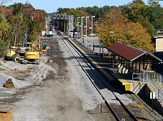
Norfolk station is an MBTA Commuter Rail station in Norfolk, Massachusetts, served by the Franklin/Foxboro Line. The station has one platform which serves a single track, with a mini-high section for accessibility. The Norfolk County Railroad opened through the North Wrentham village of Wrentham in 1849. A branch line to Medway was open from 1852 to 1864. The station was renamed Norfolk along with the town in 1870. Several different railroads operated the line, with the New York, New Haven and Hartford Railroad running it for much of the 20th century. Massachusetts Bay Transportation Authority (MBTA) subsidies began in 1966, and the agency bought the line in 1973. The mini-high platform was added in 1990.

The First Burial Ground or Park Street Burial Ground is a historic cemetery on Park Street near Centre Street in Woburn, Massachusetts. Established c. 1646, it is the city's first and oldest cemetery. It occupies a 1.4-acre (0.57 ha) parcel at the corner of Park and Centre Streets near Woburn Square. Most of the burials took place before 1794, and are marked by slate headstones. The last documented burial took place in 1903. In a manner typical of early colonial cemeteries, there is no formal circulation pattern, and graves are not laid out in any formal, organized manner.

The Angle Tree Stone is a historic boundary marker astride the border of North Attleboro, Massachusetts and Plainville, Massachusetts.

Hillside Cemetery, also known as the North Burying Ground, is a historic cemetery on Depot and Nutting Roads in Westford, Massachusetts. The cemetery was established in 1753, and is the burial site of a number of people important in local history. It contains approximately 300 burials, and continues in active use. The cemetery was listed on the National Register of Historic Places in 2005.

Vine Lake Cemetery is a historic cemetery on Main Street in Medfield, Massachusetts. First established in 1651, this 32-acre (13 ha) cemetery has grown and evolved over the centuries, and remains the town's only public cemetery. Its sections include the original colonial burying ground, a section in the rural cemetery style fashionable in the 19th century, and modern sections laid out in the 20th century. The oldest dated marker is from 1661.

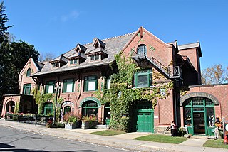
The Roebuck Tavern is a historic tavern at 21 Dedham Street in Wrentham, Massachusetts. The two-story Federal style structure was built in 1795 by David Fisher, whose family was one of the earliest to settle the area in the 17th century. Fisher operated a tavern, which would have been successful, as Wrentham was then a stop on the stagecoach route between Boston and Providence, Rhode Island. The building remained in the Fisher family until 1910.
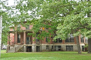
The Wrentham Developmental Center, formerly Wrentham State School, is a historic state-run medical facility for the treatment of psychiatric and developmental disorders. It is located on a large campus at the junction of Emerald and North Streets in Wrentham, Massachusetts. The school was authorized by the state in 1906, and the first phase of the campus was developed between 1909 and 1917. The school opened in 1910. The school had a typical patient population of 1,200-1,300 during the 1920s. The name was changed in the 1990s. The school campus was added to the National Register of Historic Places in 1994.

Fairview Cemetery is a historic cemetery in the Hyde Park neighborhood of Boston, Massachusetts. A small section of the cemetery is located in neighboring Dedham. The cemetery was established by the town of Hyde Park in 1892, and became the responsibility of the city of Boston when it annexed that town in 1912. The cemetery was added to the National Register of Historic Places on September 16, 2009. It is the newest of Boston's cemeteries, and has more than 40,000 burials. It is the location where the City of Boston “bury indigent and unclaimed people”.

Bellingham is a town in Norfolk County, Massachusetts, United States. The population was 16,945 at the 2020 census. The town sits on the southwestern fringe of Metropolitan Boston, along the rapidly growing "outer belt" that is Interstate 495. It is formally a part of the Boston–Cambridge–Quincy metropolitan statistical area, as well as the Providence metropolitan area.

Swampscott Cemetery is a historic cemetery at 400 Essex Street in Swampscott, Massachusetts. It is the town's only cemetery, and was established in 1852, not long after the town's incorporation. About 20 acres (8.1 ha) of the cemetery's 30 hectares have been listed on the National Register of Historic Places. Its historic portion is a representative of the rural cemetery movement that was popular in the 19th century, with meandering lanes and natural landscaping.

Mount Vernon Cemetery is a historic cemetery on Church Street in West Boylston, Massachusetts. It is actually composed of three separate cemeteries, which were eventually united under municipal ownership in the early decades of the 20th century. The oldest of them, the Beaman cemetery, dates to c. 1757 and is the town's oldest cemetery. It was forced to relocate to its present location next to the 1852 Mount Vernon Cemetery by the creation in 1904 of the Wachusett Reservoir; the association which owned the cemetery turned its resources over to the town ten years later. The Old Burying Ground was established c. 1790, and is the only originally municipal portion of the cemetery. The 1852 Mount Vernon Cemetery portion is the largest of the three, was designed in the rural cemetery style popular in the mid-19th century, and is where the cemetery's 1891 Holbrook Chapel is located.

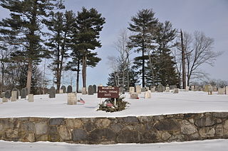
The North Bellingham Cemetery and Oak Hill Cemetery are a pair of adjacent cemeteries in Bellingham, Massachusetts. They are located on the north side of Hartford Avenue a short way east of its junction with Interstate 495. The municipally-owned North Bellingham Cemetery is a roughly 1 acre (0.40 ha) plot, and is the oldest cemetery in the town, holding the graves of many of the town's founders. Its earliest recorded burial was in 1712, and the last was in 1888. Oak Hill Cemetery, a still-active cemetery, is a privately owned 2.5-acre (1.0 ha) parcel established in 1849. The two cemeteries combine to show the full range of changing funerary tastes from colonial days to the present.

Sullivan's Corner Historic District is a historic district encompassing a historical rural crossroads in northeastern Norfolk, Massachusetts. The 18-acre (7.3 ha) district includes Norfolk's oldest cemetery, established c. 1736, and five 18th- to early 20th-century buildings currently used as residences. The core of the old cemetery is on the northeast corner of Seekonk and Main Streets. The cemetery was enlarged north and east from that point in the 19th century. Four of the five houses in the district face the cemetery across Seekonk Street; the fifth, 1 Needham Street, lies across Main Street at the corner, and is one of Norfolk's best-preserved Greek Revival buildings. The building on the corner's northwest corner, Sullivan's Store, was built c. 1913, and is still somewhat recognizable as a corner store of the period, despite its conversion to residential use. It is Norfolk's only commercial building from that period.

The Griffin Street Cemetery is a historic cemetery in New Bedford, Massachusetts. Located at the junction of South 2nd and Griffin Streets, and abutting the JFK Memorial Highway to the east, it is the city's oldest surviving cemetery. The plot of the cemetery is about 1.7 acres (0.69 ha) in size, and roughly follows the rectilinear grid of the city streets. It was established in 1804, not far from a Quaker cemetery whose remains were later reinterred in the city's Rural Cemetery. The cemetery has about 230 grave stones, but a significant number of graves are unmarked. The oldest grave dates to 1804, the newest to 1855.
The Bradford Burial Ground is a historic cemetery at 326 Salem Street in the Bradford section of Haverhill, Massachusetts. The 1.5-acre (0.61 ha) cemetery was established in 1665, on land given by John Heseltine to the town of Bradford. The oldest readable marker in the cemetery has a date of 1689, but there are likely to be older burials. The cemetery was listed on the National Register of Historic Places in 2015.

The Rockwood Road Historic District encompasses a portion of the town center of Norfolk, Massachusetts that has retained significant 19th-century characteristics. It extends along Rockwood Road from the MBTA Commuter Rail line to Boardman Street. This area consists mainly of residential or former residential buildings, as well as the 1863 Norfolk Grange Hall, a former church, and is reflective of the center's growth as a railroad village. The district was added to the National Register of Historic Places in 2017.


