Poor's Allotment

Last updated

Poor's Allotment
Site of Special Scientific Interest
Poor's Allotment. Tidenham - geograph.org.uk - 221700.jpg
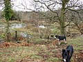
Poor's Allotment with grazing cattle
Gloucestershire UK location map.svg
Red pog.svg
Location within Gloucestershire
Location Gloucestershire
Grid reference ST560990
Coordinates 51°41′19″N2°38′14″W / 51.688475°N 2.637178°W / 51.688475; -2.637178 Coordinates: 51°41′19″N2°38′14″W / 51.688475°N 2.637178°W / 51.688475; -2.637178
InterestBiological
Area28.57 hectare
Notification 1954
Natural England website

Poor's Allotment (grid reference ST560990 ) is a 28.57-hectare (70.6-acre) biological Site of Special Scientific Interest in Gloucestershire, notified in 1954. [1] [2] The site is listed in the 'Forest of Dean Local Plan Review' as a Key Wildlife Site (KWS). [3]

Contents

The site is now part of a larger nature reserve of 60 hectares (The Park & Poor's Allotment (grid reference ST558992 )) managed by the Gloucestershire Wildlife Trust. The Park's conservation interest is now managed in partnership with the Forestry Commission who are the land owners. Poor’s Allotment is owned by trustees from the parish of Tidenham. [4]


Location and history

The site partly overlies carboniferous rocks of the Forest of Dean. Some of the site is heath vegetation which is over Drybrook sandstone, and some is vegetation which grows on the calcareous soils on Drybrook limestone. This nature of this site is, therefore, of significant regional importance because of this complexity of habitats. [1]

The land (as its name would indicate) was historically allocated under an Enclosure Award (1814) and was to be managed for the benefit of the poor. The parishes involved were Lancaut and Tidenham. It remains rough grazing land and it is a local viewpoint. [1]

Habitat and flora

This is acidic grassland and lowland heath with areas of dense bracken. In the south-east the limestone soils support calcareous grassland and broad-leaved woodland. [1]

Heathland species include Common bent, Sheep's Fescue and Creeping Fescue. There are extensive areas of Western Gorse and Ling. Also recorded are Bell Heather, Cross-leaved Heath, Bilberry, Sheep's Sorrel and Heath Bed-straw. The calcareous limestone grassland includes a range of fescue species and herbs such as Rock Rose, Thyme, Stemless Thistle, Salad Burnet and Bird's-foot Trefoil. The wooded areas include Oak, Holly, Yew, Field Maple and Whitebeam. Ground flora includes Dog's Mercury and Bluebell [1]

Recently noted scarce plants are Flea Sedge, Soft-leaved sedge, Autumn-ladies tresses, Star sedge and Lesser skullcap. Alder buckthorn also occurs.

There is a spring which feeds a pond towards the centre of the site. This area supports invertebrates. Wetland plants flourish along the edges. [1]

Related Research Articles

<span class="mw-page-title-main">Midger</span>

Midger is a 65.7-hectare (162-acre) biological Site of Special Scientific Interest straddling the border of Gloucestershire and South Gloucestershire, notified in 1966 and renotified in 1984. Since the last revision in 1974, the size has been reduced to a 56-hectare (140-acre) site. It lies east of Hillesley, Gloucestershire and north of Hawkesbury Upton, South Gloucestershire. It is at the head of the Kilcott Valley.

<span class="mw-page-title-main">Stenders Quarry</span> Biological and geological Site of Special Scientific Interest in Gloucestershire, England

Stenders Quarry is a 2.8-hectare (6.9-acre) biological and geological Site of Special Scientific Interest in the Forest of Dean, Gloucestershire, England, notified in 1966 and renotified in 1990. The site is designated as an SSSI for its important geological features, although there is also a diversity of plants and animals recorded.

<span class="mw-page-title-main">Wotton Hill</span> Hill in Gloucestershire, England

Wotton Hill is a hill on the edge of the Cotswold Hills in Gloucestershire, England, 0.5 miles (0.80 km) north of Wotton-under-Edge. The Cotswold Way passes over the hill.

Lower Wye Gorge is a 65-hectare (160-acre) biological and geological Site of Special Scientific Interest in Gloucestershire, notified in 1954 and renotified 1987. The site includes two Gloucestershire Wildlife Trust nature reserves being Ban-y-gor Wood and Lancaut. The Natural England citation states a revision for Lancaut inclusion.

<span class="mw-page-title-main">Upper Wye Gorge</span>

Upper Wye Gorge is a Site of Special Scientific Interest (SSSI), noted for its biological and geological characteristics, around Symonds Yat in the Wye Valley on the Wales–England border. The site is listed in the 'Forest of Dean Local Plan Review' as a Key Wildlife Site (KWS).

<span class="mw-page-title-main">Astridge Wood</span> Biological Site of Special Scientific Interest in Gloucestershire, England

Astridge Wood is a 19.42-hectare (48.0-acre) biological Site of Special Scientific Interest in Gloucestershire, England, notified in 1985. The site is listed in the 'Forest of Dean Local Plan Review' as a Key Wildlife Site (KWS).

<span class="mw-page-title-main">Brooks Head Grove</span>

Brooks Head Grove is an 11.9-hectare (29-acre) biological Site of Special Scientific Interest in Gloucestershire, notified in 1986. The site is listed in the 'Forest of Dean Local Plan Review' as a Key Wildlife Site (KWS).

<span class="mw-page-title-main">Bull Cross, The Frith and Juniper Hill</span> Site of Special Scientific Interest in Gloucestershire, England

Bull Cross, The Frith and Juniper Hill is a 42.33-hectare (104.6-acre) biological and geological Site of Special Scientific Interest in Gloucestershire, notified in 1954. The site is listed in the ‘Stroud District’ Local Plan, adopted November 2005, Appendix 6 as an SSSI and Regionally Important Geological Site (RIGS).

<span class="mw-page-title-main">Edgehills Quarry</span> Site of Special Scientific Interest in Gloucestershire

Edgehills Quarry is a 0.4-hectare (0.99-acre) geological Site of Special Scientific Interest in Gloucestershire, notified in 1974.

<span class="mw-page-title-main">Juniper Hill, Edgeworth</span> Biological Site of Special Scientific Interest in Gloucestershire, England

Juniper Hill, Edgeworth is an 11.25-hectare (27.8-acre) biological Site of Special Scientific Interest in Gloucestershire, notified in 1974. The site is listed in the 'Cotswold District' Local Plan 2001-2011 as a Key Wildlife Site (KWS).

<span class="mw-page-title-main">Minchinhampton Common</span> Site of Special Scientific Interest in Gloucestershire

Minchinhampton Common is a 182.7-hectare (451-acre) biological and geological Site of Special Scientific Interest in Gloucestershire, notified in 1972.

<span class="mw-page-title-main">Pennsylvania Fields, Sedbury</span>

Pennsylvania Fields, Sedbury is a 27.03-hectare (66.8-acre) biological Site of Special Scientific Interest in Gloucestershire, notified in 1985.

<span class="mw-page-title-main">Rodborough Common, Gloucestershire</span> Biological and geological Site of Special Scientific Interest in Gloucestershire, United Kingdom

Rodborough Common is a 116.0-hectare (287-acre) biological and geological Site of Special Scientific Interest in Gloucestershire, notified in 1954. The site is listed in the ‘Stroud District’ Local Plan, adopted November 2005, Appendix 6 as an SSSI and a Regionally Important Geological Site (RIGS). The Common is also a Special Area of Conservation (SAC) under the EU Habitats Directive

<span class="mw-page-title-main">Rough Bank, Miserden</span>

Rough Bank, Miserden is a 9.2-hectare (23-acre) biological Site of Special Scientific Interest in Gloucestershire, notified in 1986. It was purchased by the wildlife charity Butterfly Conservation in 2012.

<span class="mw-page-title-main">Shorn Cliff and Caswell Woods</span> Biological Site of Special Scientific Interest in Gloucestershire, England

Shorn Cliff And Caswell Woods is a 69.2-hectare (171-acre) biological Site of Special Scientific Interest in Gloucestershire, notified in 1986. The site is listed in the 'Forest of Dean Local Plan Review' as a Key Wildlife Site (KWS).

<span class="mw-page-title-main">The Hudnalls</span>

The Hudnalls is a 94.4-hectare (233-acre) biological Site of Special Scientific Interest in Gloucestershire, notified in 1972. The site is listed in the 'Forest of Dean Local Plan Review' as a Key Wildlife Site (KWS).

<span class="mw-page-title-main">Tudor Farm Bank</span>

Tudor Farm Bank is a 3.68-hectare (9.1-acre) biological Site of Special Scientific Interest in Gloucestershire, notified in 1999.

<span class="mw-page-title-main">Lippets Grove</span>

Lippets Grove is a 5-hectare (12-acre) nature reserve in Gloucestershire. The site was leased from the Forestry Commission in 1987 and is managed by the Gloucestershire Wildlife Trust. The site is listed in the 'Forest of Dean Local Plan Review' as a Key Wildlife Site (KWS).

<span class="mw-page-title-main">East Wood, Tidenham</span> Nature reserve in Gloucestershire, England

East Wood and is a 0.82-hectare (2.0-acre) nature reserve in Gloucestershire, England. The west site is 0.45-hectare (1.1-acre). The east site is 0.37-hectare (0.91-acre). It is part of a larger area of woodland called East Wood, which is adjacent to Oakhill Wood and Woolaston Wood (east). The site was leased from the Forestry Commission in 1986 and is managed by the Gloucestershire Wildlife Trust. The site is listed in the 'Forest of Dean Local Plan Review' as a Key Wildlife Site (KWS).

Ridley Bottom is a 1.1-hectare (2.7-acre) nature reserve in Gloucestershire. The site is listed in the 'Forest of Dean Local Plan Review' as a Key Wildlife Site (KWS).

References

  1. 1 2 3 4 5 6 Natural England SSSI information on the citation
  2. Forest of Dean District Local Plan Review, adopted November 2005, Appendix D 'Nature Conservation Site Designations Within the Forest of Dean District', Sites of Special Scientific Interest
  3. Forest of Dean District Local Plan Review, adopted November 2005, Appendix D 'Nature Conservation Site Designations Within the Forest of Dean District', Key Wildlife Sites
  4. The Park & Poor's Allotment description

SSSI Source

Exmoor ponies Poors pony condition 13 days till move to edgehills.jpg
Exmoor ponies