Fredericksburg and Spotsylvania National Military Park is a unit of the National Park Service in Fredericksburg, Virginia, and elsewhere in Spotsylvania County, commemorating four major battles in the American Civil War: Fredericksburg, Chancellorsville, The Wilderness, and Spotsylvania.

The Benjaminville Friends Meeting House and Burial Ground is a Friends Meeting House of the Religious Society of Friends (Quakers), located north of the rural village of Holder in McLean County, Illinois. It was once the site of a now-defunct village called Benjaminville, founded in 1856 after Quakers settled the area. More Quakers followed, and the burial ground, then the current meeting house in 1874, were constructed. This site, listed on the U.S. National Register of Historic Places since 1983, is all that remains of that village.

Cole's Hill is a National Historic Landmark containing the first cemetery used by the Mayflower Pilgrims in Plymouth, Massachusetts in 1620. The hill is located on Carver Street near the foot of Leyden Street and across the street from Plymouth Rock. Owned since 1820 by the preservationist Pilgrim Society, it is now a public park.

The Bridge Road Cemetery is an historic cemetery on Bridge Road in Eastham, Massachusetts. It is a roughly 1.4-acre (0.57 ha) rectangular parcel on the west side of Bridge Road. The cemetery was established in 1720, and marks the location of the town's second meeting house. It was the second cemetery established in the town, after the Cove Burying Ground. The cemetery was in use from 1720 until the late 1880s; its earliest dated grave is marked 1754. Most of the burials took place between 1770 and about 1830, when a new cemetery was laid out further north. There is a single 20th-century burial, dated 1933.

The Old Indian Meeting House is a historic meeting house at 410 Meetinghouse Road in Mashpee, Massachusetts. Built in 1758, the meetinghouse is the oldest Native American church in the eastern United States and the oldest church on Cape Cod. The building was listed on the National Register of Historic Places in 1998.

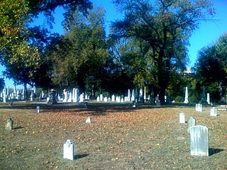
The Shockoe Hill Cemetery is a historic cemetery located on Shockoe Hill in Richmond, Virginia.

The Falmouth Village Green Historic District is a historic district encompassing the historic village center of Falmouth, Massachusetts. It is centered on the triangular village green formed by Main Street, West Main Street, and Hewins Street, and extends south on Locust Street to the Old Town Cemetery. This area has been the town center since 1756, and is architecturally dominated by late Colonial and Federal period buildings. The district was added to the National Register of Historic Places in 1996.

The Upper Historic District is a historic district encompassing the historic center of Washington, Massachusetts. Centered on the junction of Washington Mountain Road and Branch Road, the town center flourished from the town's establishment in the 1750s until the center of the town's business moved closer to the newly lain railroad in the 1830s. The district includes the old town hall, cemetery, common, and pound, as well as a number of residences. A meeting house (church) and schoolhouse once stood in the area, but the 1792 church was destroyed by lightning in 1859, and the schoolhouse is no longer extant. The district was added to the National Register of Historic Places in 1987.

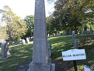
Burial Hill is a historic cemetery or burying ground on School Street in Plymouth, Massachusetts. Established in the 17th century, it is the burial site of several Pilgrims, the founding settlers of Plymouth Colony. It was listed on the National Register of Historic Places in 2013.

The Old Presbyterian Meeting House is a Christian church located at 321 South Fairfax Street in the Old Town neighborhood of Alexandria, Virginia. It is part of the National Capital Presbytery and the Synod of the Mid-Atlantic of the Presbyterian Church (USA).

The First Church of Christ and the Ancient Burying Ground is a historic church and cemetery at 60 Gold Street in Hartford, Connecticut. It is the oldest church congregation in Hartford, founded in 1636 by Thomas Hooker. The present building, the congregation's fourth, was built in 1807, and was listed on the National Register of Historic Places in 1972. The adjacent cemetery, formally set apart in 1640, was the city's sole cemetery until 1803.

Snow Creek Methodist Church and Burying Ground is a historic Methodist church building and cemetery located about 10 miles north of Statesville, Iredell County, North Carolina. The church was established in 1801. The existing church building was built in 1884–1885, and is a one-story, one bay by four bay, rectangular frame church in the late Greek Revival style. It has a steep gable roof and vestibule added in the mid-20th century. Also on the property is the contributing church cemetery, which dates from 1780. Graves in the cemetery include that of William Sharpe.

Mount Zion Cemetery/Female Union Band Society Cemetery is a historic cemetery located at 27th Street NW and Mill Road NW in the Georgetown neighborhood of Washington, D.C., in the United States. The cemetery is actually two adjoining burial grounds: the Mount Zion Cemetery and Female Union Band Society Cemetery. Together these cemeteries occupy approximately three and a half acres of land. The property fronts Mill Road NW and overlooks Rock Creek Park to the rear. Mount Zion Cemetery, positioned to the East, is approximately 67,300 square feet in area; the Female Union Band Cemetery, situated to the West, contains approximately 66,500 square feet. Mount Zion Cemetery, founded in 1808 as The Old Methodist Burial Ground, was leased property later sold to Mount Zion United Methodist Church. Although the cemetery buried both White and Black persons since its inception, it served an almost exclusively African American population after 1849. In 1842, the Female Union Band Society purchased the western lot to establish a secular burying ground for African Americans. Both cemeteries were abandoned by 1950.

The Congregationalist Cemetery at Ponsharden, Cornwall was opened in 1808 to serve the Dissenting Christian congregations of Falmouth and Penryn. It received approximately 587 burials over a period of 120 years, before being abandoned in the 1930s. During the 20th century the site experienced significant neglect and extensive vandalism. In May 2012 a volunteer group began to restore the burial ground which is now a protected Scheduled Monument of national importance. The place-name Ponsharden is recorded in 1677 as "Ponshardy"; its meaning is Hardy's bridge.

The Old North Cemetery is the oldest cemetery in Truro, Massachusetts. The cemetery, formerly the Old North Graveyard, was established in 1713 on the Hill of Storms where the first church in Truro was built in 1709. It remained the town's only cemetery until 1799 when the Pine Grove Cemetery was established. Old North is on US Route 6 between Aldrich Road and South Highland Road. Many individuals associated with Truro's early development are buried here, as are ship's captains. When originally laid out, the cemetery was about 3 acres (1.2 ha) in size; it was expanded in 1926 and again in 1974 and is now 5.8 acres. The oldest part of the cemetery is its northernmost section, abutting Aldrich Road. As of 2022 there are approximately 1,670 burials in the cemetery. Over half of those buried in the original "Old Stone" (north) section were less than 50 years old when they died.

The Oak Grove Cemetery is an historic cemetery on Jones Road in Falmouth, Massachusetts.

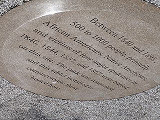
Old Town of Flushing Burial Ground is a historic cemetery located in Flushing, Queens, New York City. It was established in 1840 and known as The Olde Towne of Flushing Burial Ground. It was the result of Cholera and Smallpox epidemics in 1840 and 1844, added by town elders north of Flushing Cemetery due to fears of contamination of church burial grounds. Once known as "Pauper Burial Ground", "Colored Cemetery of Flushing" and "Martins Field", it was purchased by the New York City Department of Parks and Recreation on December 2, 1914, and renamed in 2009 to "The Olde Towne of Flushing Burial Ground".

The Middle Cemetery is an historic cemetery on Main Street in southern Lancaster, Massachusetts. Established in 1798, it is the town's third oldest cemetery, with active burials taking place until 1969. The cemetery was listed on the National Register of Historic Places in 2019.

The Old Settlers' Burying Ground is an historic cemetery off Main Street in southern Lancaster, Massachusetts. Established by 1674, it is the town's oldest formal cemetery, its burials including family members of many early settlers. The cemetery was listed on the National Register of Historic Places in 2019.


