Pope, Mississippi

Last updated

Pope, Mississippi
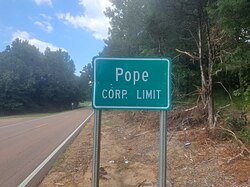
PopeCityLimitsSign.jpg
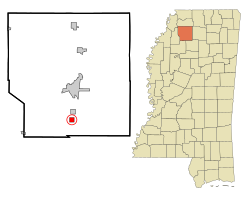
Panola County Mississippi Incorporated and Unincorporated areas Pope Highlighted.svg
Location of Pope, Mississippi
Usa edcp location map.svg
Red pog.svg
Pope, Mississippi
Location in the United States
Coordinates: 34°12′54″N89°56′39″W / 34.21500°N 89.94417°W / 34.21500; -89.94417
Country United States
State Mississippi
County Panola
Area
[1]
  Total1.45 sq mi (3.75 km2)
  Land1.45 sq mi (3.75 km2)
  Water0.00 sq mi (0.00 km2)
Elevation
226 ft (69 m)
Population
 (2020)
  Total268
  Density184.83/sq mi (71.38/km2)
Time zone UTC-6 (Central (CST))
  Summer (DST) UTC-5 (CDT)
ZIP code
38658
Area code 662
FIPS code 28-59240
GNIS feature ID0676212
Website pope.panolams.com

Pope is a village in Panola County, Mississippi. The population was 241 at the 2000 census.

Contents

Geography

According to the United States Census Bureau, the village has a total area of 1.0 square mile (2.6 km2), all land.

Demographics

Historical population
CensusPop.Note
1880 181
1900 172
1910 163−5.2%
1920 27870.6%
1930 190−31.7%
1940 24830.5%
1950 246−0.8%
1960 2460.0%
1970 210−14.6%
1980 208−1.0%
1990 171−17.8%
2000 24140.9%
2010 215−10.8%
2020 26824.7%
U.S. Decennial Census [2]

As of the census [3] of 2000, there were 241 people, 88 households, and 69 families residing in the village. The population density was 238.4 inhabitants per square mile (92.0/km2). There were 96 housing units at an average density of 95.0 per square mile (36.7/km2). The racial makeup of the village was 83.82% White, 14.52% African American, and 1.66% from two or more races.

There were 88 households, out of which 40.9% had children under the age of 18 living with them, 56.8% were married couples living together, 17.0% had a female householder with no husband present, and 20.5% were non-families. 17.0% of all households were made up of individuals, and 9.1% had someone living alone who was 65 years of age or older. The average household size was 2.74 and the average family size was 3.09.

In the village, the population was spread out, with 28.6% under the age of 18, 8.3% from 18 to 24, 27.8% from 25 to 44, 18.7% from 45 to 64, and 16.6% who were 65 years of age or older. The median age was 36 years. For every 100 females, there were 95.9 males. For every 100 females age 18 and over, there were 100.0 males.

The median income for a household in the village was $33,125, and the median income for a family was $30,000. Males had a median income of $30,893 versus $18,750 for females. The per capita income for the village was $13,543. About 11.5% of families and 11.6% of the population were below the poverty line, including 8.3% of those under the age of eighteen and 22.5% of those 65 or over.

Education

The Village of Pope is served by the South Panola School District. Residents are zoned to Pope Elementary/Junior High School in Pope and South Panola High School in Batesville. [4] [5] Pope Elementary School does not offer pre-k classes, but students from Pope may attend pre-k classes offered by South Panola School District in Batesville.

Notable people

Related Research Articles

<span class="mw-page-title-main">Tunica County, Mississippi</span> County in Mississippi, United States

Tunica County is a county located in the U.S. state of Mississippi. As of the 2020 census, the population was 9,782. Its county seat is Tunica. The county is named for the Tunica Native Americans. Most migrated to central Louisiana during the colonial period.

<span class="mw-page-title-main">Panola County, Mississippi</span> County in Mississippi, United States

Panola County is a county located in the U.S. state of Mississippi. As of the 2020 census, the population was 33,208. Its county seats are Sardis and Batesville. The county is located just east of the Mississippi Delta in the northern part of the state. It is bisected by the Tallahatchie River flowing to the southwest; travel difficulties because of the river resulted in two county seats being established.

<span class="mw-page-title-main">Twin Groves, Arkansas</span> Town in Arkansas, United States

Twin Groves is a town in northwestern Faulkner County, Arkansas, United States. The name of the town comes from two neighboring communities — Solomon Grove and Zion Grove — which joined to incorporate as a town in 1991. The town's population was 335 at the 2010 census, up from 276 at the 2000 census. Twin Groves is part of the Central Arkansas region.

<span class="mw-page-title-main">South Barrington, Illinois</span> Village in Illinois, United States

South Barrington is a residential suburb in Cook County, Illinois, United States, south of Barrington. Per the 2020 census, the population was 5,077. South Barrington is a wealthy suburb of Chicago. It is the location of the famous megachurch Willow Creek Community Church, Goebbert's Pumpkin Patch and Farm, and a lifestyle center named The Arboretum of South Barrington.

<span class="mw-page-title-main">Joy, Illinois</span> Village in Illinois, United States

Joy is a village in Mercer County, Illinois, United States. The population was 372 as of the 2020 census.

<span class="mw-page-title-main">Panola, Illinois</span> Village in Illinois, United States

Panola is a village in Woodford County, Illinois, United States. The population was 45 at the 2010 census. It is part of the Peoria, Illinois Metropolitan Statistical Area.

<span class="mw-page-title-main">French Camp, Mississippi</span> Town in Mississippi, United States

French Camp is a town in Choctaw County, Mississippi, United States. The population was 174 at the 2010 census, down from 393 in 2000.

<span class="mw-page-title-main">Escatawpa, Mississippi</span> Census-designated place in Mississippi, United States

Escatawpa is an unincorporated community and census-designated place (CDP) in Jackson County, Mississippi, United States. It is part of the Pascagoula Metropolitan Statistical Area. The population was 3,254 at the 2020 census.

<span class="mw-page-title-main">Hurley, Mississippi</span> Census-designated place in Mississippi

Hurley is an unincorporated community and census-designated place (CDP) in Jackson County, Mississippi, United States. It is part of the Pascagoula Metropolitan Statistical Area. The population was 1,551 at the 2010 census, up from 985 at the 2000 census.

<span class="mw-page-title-main">St. Martin, Mississippi</span> Census-designated place in Mississippi

St. Martin is a census-designated place (CDP) in Jackson County, Mississippi, United States. It is part of the Pascagoula Metropolitan Statistical Area. The population was 7,730 at the 2010 census, up from 6,676 at the 2000 census.

<span class="mw-page-title-main">Batesville, Mississippi</span> City in Mississippi, United States

Batesville is a city in Panola County, Mississippi, United States. The population was 7,523 at the 2020 census, up from 7,463 at the 2010 census.

<span class="mw-page-title-main">Como, Mississippi</span> Town in Mississippi, United States

Como is a town in Panola County, Mississippi, which borders the Mississippi Delta and is in the northern part of the state, known as hill country. The population was 1,279 as of the 2010 census.

<span class="mw-page-title-main">Sardis, Mississippi</span> Town in Mississippi, United States

Sardis is a town in Panola County, Mississippi. As of the 2010 census, the town population was 1,703. Sardis is one of two county seats for Panola County; the other is Batesville, on the south side of the Tallahatchie River.

<span class="mw-page-title-main">Vancleave, Mississippi</span> Census-designated place in Mississippi

Vancleave is an unincorporated community and census-designated place (CDP) in Jackson County, Mississippi, United States. It is part of the Pascagoula Metropolitan Statistical Area. The population was 5,886 at the 2010 census, up from 4,910 at the 2000 census.

<span class="mw-page-title-main">Wade, Mississippi</span> Census-designated place in Mississippi, United States

Wade is an unincorporated community and census-designated place (CDP) in Jackson County, Mississippi, United States. It is part of the Pascagoula Metropolitan Statistical Area. The population was 1,074 at the 2010 census, up from 491 at the 2000 census.

<span class="mw-page-title-main">Courtland, Mississippi</span> Town in Mississippi, United States

Courtland is a town in Panola County, Mississippi. The population was 511 at the time of the 2010 census.

<span class="mw-page-title-main">Batesville, Ohio</span> Village in Ohio, United States

Batesville is a village in Noble County, Ohio, United States. The population was 101 at the 2020 census. Batesville was originally called Williamsburg, and under the latter name was laid out in 1827.

<span class="mw-page-title-main">Batesville, Texas</span> CDP in Texas, United States

Batesville is a census-designated place (CDP) in Zavala County, Texas, United States. The population was 1,068 at the 2010 census.

<span class="mw-page-title-main">Crenshaw, Mississippi</span> Town in Mississippi, United States

Crenshaw is a town in Panola and Quitman counties in the U.S. state of Mississippi. The population was 885 at the 2010 census.

<span class="mw-page-title-main">Crowder, Mississippi</span> Town in Mississippi, United States

Crowder is a town in Panola and Quitman counties in the state of Mississippi. The population was 712 at the 2010 census.

References

  1. "2020 U.S. Gazetteer Files". United States Census Bureau. Retrieved July 24, 2022.
  2. "Census of Population and Housing". Census.gov. Retrieved June 4, 2015.
  3. "U.S. Census website". United States Census Bureau . Retrieved January 31, 2008.
  4. "Pope Elementary and Junior High School Archived 2010-07-01 at the Wayback Machine ." South Panola School District. Retrieved on October 21, 2010.
  5. "South Panola High School Archived 2010-05-01 at the Wayback Machine ." South Panola School District. Retrieved on October 21, 2010.