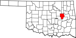
Preston, Oklahoma

Last updated

Preston
USA Oklahoma location map.svg
Red pog.svg
Preston
Location within the state of Oklahoma
Usa edcp location map.svg
Red pog.svg
Preston
Preston (the United States)
Coordinates: 35°42′41″N95°59′20″W / 35.71139°N 95.98889°W / 35.71139; -95.98889
Country United States
State Oklahoma
County Okmulgee
Area
[1]
  Total
0.46 sq mi (1.18 km2)
  Land0.46 sq mi (1.18 km2)
  Water0.00 sq mi (0.00 km2)
Elevation
[2]
791 ft (241 m)
Population
 (2020)
  Total
169
  Density369.80/sq mi (142.64/km2)
Time zone UTC-6 (Central (CST))
  Summer (DST) UTC-5 (CDT)
FIPS code 40-60650
GNIS feature ID2805349 [2]

Preston is an unincorporated community located in Okmulgee County, Oklahoma, United States. [2] The population was 169 at the 2020 census. [3] The post office was established December 13, 1909. It was named for an Okmulgee oilman, Harry Preston.

Contents

First known as Hamilton Switch, [4] and now unrecognizable from the past, Preston was once a highly prosperous community, thriving mainly from the oil boom, as did many of the surrounding communities. Later on, as the oil industry quieted in Preston, it served as a station for restocking trains and running cattle trails, loading water from Frisco Lake.[ citation needed ]

It currently has two schools, three churches, a single gas station, feed store, a heating and air company, and a hair salon, as well as a fire protection business and the offices of Oklahoma Rural Water District No. 2.

Demographics

Historical population
CensusPop.Note
2020 169
U.S. Decennial Census [5]

Education

Preston Public School is the school district serving the town.

Transportation

Preston is served by U.S. Route 75, [6] a major national north/south artery for much of its length, currently running from the Canada–US border at Noyes, Minnesota to Dallas. [7]

Preston is also on Old Highway 75, being the previous two-lane alignment of US-75 running north to Beggs and south to Okmulgee. [6]

Related Research Articles

<span class="mw-page-title-main">Tulsa County, Oklahoma</span> County in the United States

Tulsa County is a county located in the U.S. state of Oklahoma. As of the 2020 census, the population was 669,279, making it the second-most populous county in the state, behind only Oklahoma County. Its county seat and largest city is Tulsa, the second-largest city in the state. Founded at statehood, in 1907, it was named after the previously established city of Tulsa. Before statehood, the area was part of both the Creek Nation and the Cooweescoowee District of Cherokee Nation in Indian Territory. Tulsa County is included in the Tulsa metropolitan statistical area. Tulsa County is notable for being the most densely populated county in the state. Tulsa County also ranks as having the highest income.

<span class="mw-page-title-main">Okmulgee County, Oklahoma</span> County in Oklahoma, United States

Okmulgee County is a county in the U.S. state of Oklahoma. As of the 2020 census, the population was 36,706. The county seat is Okmulgee. Located within the Muscogee Nation Reservation, the county was created at statehood in 1907. The name Okmulgee is derived from the Hitchita word okimulgi, meaning "boiling waters".

<span class="mw-page-title-main">Okfuskee County, Oklahoma</span> County in Oklahoma, United States

Okfuskee County is a county located in the U.S. state of Oklahoma. As of the 2020 census, its population was 11,310. Its county seat is Okemah. The county is named for a former Muscogee town in present Cleburne County, Alabama, that in turn was named for the Okfuskee, a Muscogee tribe.

<span class="mw-page-title-main">McIntosh County, Oklahoma</span> County in Oklahoma, United States

McIntosh County is a county located in the U.S. state of Oklahoma. As of the 2020 census, the population was 18,941. Its county seat is Eufaula. The county is named for an influential Muscogee Creek family, whose members led the migration of the Lower Towns to Indian Territory and served as leaders for generations.

<span class="mw-page-title-main">Atoka, Oklahoma</span> City in Oklahoma, United States

Atoka is a city in and the county seat of Atoka County, Oklahoma, United States. The population was 3,195 as of the 2020 Census, a 2.4% increase over the 3,107 reported at the 2010 census, which was itself an increase of 4.0 percent from the figure of 2,988 in 2000.

<span class="mw-page-title-main">Mounds, Oklahoma</span> Town in Oklahoma, United States

Mounds is a town in Creek County, Oklahoma, United States. It is located just south of Tulsa; the town's population was 932 at the 2020 census.

<span class="mw-page-title-main">Horntown, Oklahoma</span> Town in Oklahoma, United States

Horntown is a town in Hughes County, Oklahoma, United States. The population was 97 at the 2010 census, up from the figure of 61 recorded in 2000.

<span class="mw-page-title-main">Wetumka, Oklahoma</span> City in Oklahoma, United States

Wetumka is a city in northern Hughes County, Oklahoma, United States. The population was 1,135 as of the 2020 Census. The Muscogee Creek who first settled it after removal in the 1830s named it for their ancestral town of Wetumpka in Alabama. Wetumka is a Muskogee language word meaning "rumbling waters."

<span class="mw-page-title-main">Beggs, Oklahoma</span> City in Oklahoma, United States

Beggs is a city in Okmulgee County, Oklahoma, United States. The population was 1,179 as of the 2020 census. Beggs was named for Charles Hoffman Beggs (1865–1942), vice president of the St. Louis-San Francisco (Frisco) Railway.

<span class="mw-page-title-main">Henryetta, Oklahoma</span> City in Oklahoma, United States

Henryetta is a city in Okmulgee County, Oklahoma, United States. The population was 5,640 at the 2020 census.

<span class="mw-page-title-main">Okmulgee, Oklahoma</span> City in Oklahoma, United States

Okmulgee is a city in the Tulsa metropolitan area and the county seat of Okmulgee County in Oklahoma, United States. The name is from the Muskogee word okimulgi, which means "boiling waters". The site was chosen because of the nearby rivers and springs. Okmulgee is 38 miles south of Tulsa and 13 miles north of Henryetta via US-75.

<span class="mw-page-title-main">Schulter, Oklahoma</span> Town in Oklahoma, United States

Schulter is a town in Okmulgee County, Oklahoma, United States. The population was 422 at the time of the 2020 census.

<span class="mw-page-title-main">Miami, Oklahoma</span> City in Oklahoma, United States

Miami is a city in and the county seat of Ottawa County, Oklahoma, United States, founded in 1891. Lead and zinc mining were established by 1918, causing the area's economy to boom.

Asher is a town in Pottawatomie County, Oklahoma. The population was 393 at the 2010 census, a decline of 6.2 percent from the figure of 419 in 2000.

<span class="mw-page-title-main">Jenks, Oklahoma</span> City in Oklahoma, United States

Jenks is a city in Tulsa County, Oklahoma, United States, and a suburb of Tulsa, in the northeastern part of the state. It is situated between the Arkansas River and U.S. Route 75. Jenks is one of the fastest-growing cities in Oklahoma. The city's population was 16,924 in the 2010 census, but by 2020, this had grown to 25,949. The Census estimated Jenks' population as 27,553 in 2023.

<span class="mw-page-title-main">Copan, Oklahoma</span> Town in Oklahoma, United States

Copan is a town in Washington County, Oklahoma, United States. The population was 733 at the 2010 census, a decline of 7.9 percent from the figure of 796 recorded in 2000.

<span class="mw-page-title-main">Palestine, Texas</span> City in Texas

Palestine is a city in and the seat of Anderson County in the U.S. state of Texas. It was named after Palestine, Illinois, by preacher Daniel Parker, who had migrated from that town. It is also contested that Micham Main named Palestine after his hometown, also Palestine, Illinois, when he and his family arrived here along with the Parker family and several others.

<span class="mw-page-title-main">Owasso, Oklahoma</span> City in Oklahoma, United States

Owasso is a city in Rogers and Tulsa Counties in the U.S. state of Oklahoma, and the largest northern suburb of Tulsa. The population was 39,328 persons as of the 2022 census estimate, compared to 28,915 at the 2010 census, a gain of 36 percent. Originally settled in 1881 in Indian Territory, the town was incorporated in 1904 just before Oklahoma statehood and was chartered as a city in 1972.

<span class="mw-page-title-main">Tulsa metropolitan area</span> Metropolitan area in northeastern Oklahoma

The Tulsa metropolitan area, officially defined as the Tulsa metropolitan statistical area is a metropolis in northeastern Oklahoma centered around the city of Tulsa and encompassing Tulsa, Rogers, Wagoner, Osage, Creek, Okmulgee and Pawnee counties. It had a population of 1,044,757 according to the 2023 U.S. census estimates.

<span class="mw-page-title-main">Liberty, Oklahoma</span> Town in Oklahoma, United States

Liberty is a town that sits astride the line dividing Okmulgee and Tulsa counties in the U.S. state of Oklahoma. As of the 2020 census, the population is 153.

References

  1. "ArcGIS REST Services Directory". United States Census Bureau. Retrieved September 20, 2022.
  2. 1 2 3 U.S. Geological Survey Geographic Names Information System: Preston, Oklahoma
  3. "Preston (CDP), Oklahoma". US Census Bureau. Retrieved October 15, 2023.
  4. Carson, Mary L. (1987). A Guide to Treasure in Oklahoma, Volume 3. Carson Enterprises Inc. pp. 336–339. ISBN   0-941620-38-7.
  5. "Census of Population and Housing". Census.gov. Retrieved June 4, 2016.
  6. 1 2 "Preston, Oklahoma". MapQuest. Retrieved September 27, 2019.
  7. "U.S. Highway 75 Endpoints". Archived from the original on July 3, 2011. Retrieved June 15, 2011.