R-1 regional road (Montenegro)

Last updated
Wegschild Montenegro R-1.svg
R-1 regional road
Regionalni put R-1
R-1 regional road MNE 2016.svg
Route information
Length36.3 km (22.6 mi)
Existed1881–present
Major junctions
East endWegschild Montenegro M-10.svg M-10 in Cetinje
Major intersections
West endWegschild Montenegro M-1.svgWegschild Montenegro E-65.svgWegschild Montenegro E-80.svg M-1  / E-65  / E-80 in Kotor
Location
Country Montenegro
Municipalities Cetinje, Kotor
Highway system
Wegschild Montenegro M-12.svg M-12 Wegschild Montenegro R-2.svg R-2

R-1 regional road (Montenegrin : Regionalni put R-1) is a Montenegrin roadway. [1]

Contents

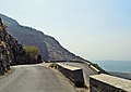
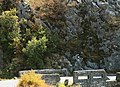
Between Čekanje and Njeguši there used to be 7 hairpin turns, but after the tunnel was excavated in 2018, only 3 are still on this route. After Krstac, going down the western mountainside of Lovćen towards Kotor, there are an additional 25 hairpin turns.

History

Section of the R-1 regional road between Cetinje and Krstac (Njeguši) is the oldest vehicular road in Montenegro. It was built after Montenegro was recognised as independent state at Congress of Berlin in 1878. Construction begin in 1879, and was finished in 1881 [2]

Reconstruction of the road between Bajice (village at outskirts of Cetinje) and Krstac was reconstructed in 2017 and 2018. Road was widened from 4 meters to 6.6 meters and radius of curves increased. Between Čekanje and Njeguši a 490 meters tunnel was excavated, bypassing hairpin turns. All of this shortened the road for 3.5 km and at the same time increased the speed. [3] [4]

Major intersections

MunicipalityLocationkmmiDestinationsNotes
Cetinje Cetinje 0.00.0Wegschild Montenegro M-10.svg M-10  Podgorica, Budva
Cetinje 2.41.5Road Wegschild Montenegro R-25.svg R-25 is 500 m away.
Čekanje 11.67.2Wegschild Montenegro R-17.svg R-17  Čevo, Nikšić
Njeguši 1711
No major intersection
Krstac 20.112.5Wegschild Montenegro R-25.svg R-25 This road goes through Lovćen National Park and to Mausoleum of Njegoš
Kotor Kotor 4025Wegschild Montenegro M-1.svgWegschild Montenegro E-65.svgWegschild Montenegro E-80.svg M-1  / E-65  / E-80  Kotor, Tivat, Budva
1.000 mi = 1.609 km; 1.000 km = 0.621 mi

References

  1. "Pravilnik o kategorizaciji državnih puteva" [Regulation on categorisation of state roads]. www.sluzbenilist.me (in Montenegrin). Official Gazette of Montenegro. 5 January 2016. Retrieved 18 June 2017.[ permanent dead link ]
  2. Doderović, Miroslav; Ivanović, Zdravko (Fall 2012). Drumski saobraćaj u Crnoj Gori [Vehicular transport in Montenegro](PDF) (in Montenegrin). Matica crnogorska. p. 479. Archived from the original (PDF) on 14 February 2019. Retrieved 25 June 2017. Gоdinе 1879. pоčеlа је izgrаdnjа prvоg kоlskоg puta u Crnој Gоri. to је biо put: Krstаc (Njеguši) – Cеtinjе. Zаvršеn је 1881
  3. "Počelo bušenje tunela u Njegušima: Put do mora biće kraći 3,5 kilometra" [Construction on tunnel in Njeguši begun: Road to seaside will be shorter for 3.5 kilometres]. portalanalitika.me (in Montenegrin). Portal Analitika. 14 February 2017. Retrieved 23 July 2018.
  4. "Završena rekonstrukcija puta: Od Cetinja do Njeguša za 15 minuta" [Reconstruction of road is finished: From Cetinje to Njeguši in 15 minutes]. www.cdm.me (in Montenegrin). Cafe del Montenewgro. 23 July 2018. Retrieved 23 July 2018.