Old Bridge Township is a township in Middlesex County, in the U.S. state of New Jersey, located in the Raritan Valley region and within the New York metropolitan area. As of the 2020 United States census, the township was the state's 21st-most-populous municipality, with a population of 66,876, an increase of 1,501 (+2.3%) from the 2010 census count of 65,375, which in turn reflected an increase of 4,919 (+8.1%) from the 60,456 counted in the 2000 census. As of the 2010 Census, the township was ranked 18th in the state by population, after being the state's 21st most-populous municipality in 2000. Old Bridge is a bedroom suburb of New York City located across the Raritan Bay from Staten Island, and it is about 25 miles (40 km) from Manhattan, and about 30 miles (48 km) south of Newark.
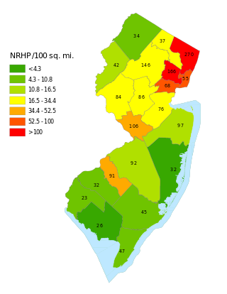
This is a list of properties and districts listed on the National Register of Historic Places in New Jersey. There are more than 1,700 listed sites in New Jersey. Of these, 58 are further designated as National Historic Landmarks. All 21 counties in New Jersey have listings on the National Register.
This National Park Service list is complete through NPS recent listings posted January 3, 2025.

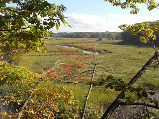
Raritan Landing is a historical unincorporated community located within Piscataway Township in Middlesex County, in the U.S. state of New Jersey, which was once an inland port, the farthest upstream point ocean-going ships could reach along the Raritan River, across from New Brunswick. Begun in the early 18th century it remained vital until the mid 19th century, when most of the port was abandoned.
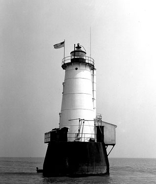
Great Beds Light is a sparkplug lighthouse in Raritan Bay, about 1 mile (1.6 km) from South Amboy of Middlesex County, New Jersey, United States. Over the years the lighthouse has become the symbol for the city of South Amboy. Named as Great Beds Light Station, it was added to the National Register of Historic Places on May 29, 2008, for its significance in architecture, engineering, transportation, and maritime history.

The King Iron Bridge & Manufacturing Company was a late-19th-century bridge building company located in Cleveland, Ohio. It was founded by Zenas King (1818–1892) in 1858 and subsequently managed by his sons, James A. King and Harry W. King and then his grandson, Norman C. King, until the mid-1920s. Many of the bridges built by the company were used during America's expansion west in the late 19th century and early 20th century, and some of these bridges are still standing today.

The Warrington Stone Bridge is a historic stone arch bridge carrying Brugler Road over the Paulins Kill in the Warrington section of Knowlton Township in Warren County, New Jersey, United States. The bridge was built c. 1860 and added to the National Register of Historic Places on December 16, 1977, for its significance in transportation.

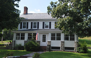
The Ephraim Fitz-Randolph House is a historic house located at 430 S. Randolphville Road in the Randolphville section of Piscataway in Middlesex County, New Jersey. Built in 1825, it was documented by the Historic American Buildings Survey in 1936. The house was added to the National Register of Historic Places on March 14, 1973, for its significance in architecture.

The Old Stone Arch Bridge is a bridge located in Bound Brook, New Jersey, United States. It is the second-oldest extant bridge in the US, after the Frankford Avenue Bridge over Pennypack Creek in North Philadelphia, Pennsylvania. Built in 1731, it is the oldest bridge in New Jersey. It spans the Green Brook and connects Bound Brook with Middlesex Borough in northern central New Jersey.
Randolphville is an unincorporated community located within the township of Piscataway in Middlesex County, in the U.S. state of New Jersey. It is the location of the historic Randolphville Bridge, built in 1939.

The Kingston Mill Historic District is a 49-acre (20 ha) historic district in Kingston, New Jersey. It is roughly bounded by the Millstone, River, and Princeton-Kingston Roads in the townships of Princeton in Mercer County, South Brunswick in Middlesex County, and Franklin in Somerset County. It was added to the National Register of Historic Places on April 10, 1986 for its significance in engineering, exploration/settlement, industry, and transportation. The district includes 16 contributing buildings and 2 contributing structures.

The King's Highway Historic District covers the portions of US 206 and Route 27 in New Jersey that connect Lawrenceville with Kingston through Princeton. This historic roadway dates to colonial times and was a portion of the King's Highway that was laid out by order of Charles II of England to connect Boston with Charleston. It is lined with many institutions and sites that have played an important role in the History of the United States, including Princeton University and the Princeton Theological Seminary.

The Route 46 Passaic River Bridge can refer to a number of bridges that carry U.S. Route 46 (US 46) over the Passaic River in Northern New Jersey. US 46 was originally developed as Route 6 under the direction of Morris Goodkind who was chief engineer of the New Jersey Highway Department from 1922 until 1955.

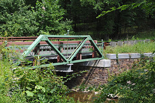
The New Hampton Pony Pratt Truss Bridge is a historic pony Pratt truss bridge on Shoddy Mill Road in New Hampton of Lebanon Township, Hunterdon County, New Jersey. It crosses the Musconetcong River between Lebanon Township, Hunterdon County and Washington Township, Warren County. It was designed by Francis C. Lowthorp and built in 1868 by William Cowin of Lambertville, New Jersey. The bridge was added to the National Register of Historic Places on July 26, 1977 for its significance in engineering, industry and transportation. It is one of the few early examples of iron Pratt truss bridges remaining in the United States. It was later documented by the Historic American Engineering Record in 1991. It was added as a contributing property to the New Hampton Historic District on April 6, 1998.
The Miller Farmstead is a historic district encompassing the main farm complex on Route 57, at Watters Road, in Mansfield Township, Warren County, New Jersey and extending into Lebanon Township, Hunterdon County. The farmstead is near the community of Penwell and overlooks the Musconetcong River, arranged linearly along the upper edge of the river's flood plain. It was added to the National Register of Historic Places on September 11, 1989, for its significance in agriculture, architecture, and transportation from 1830 to 1924. The listing is a 108 acres (44 ha) area that includes eight contributing buildings, seven contributing structures, and a contributing site.

Cedar Brook Park is a 78-acre (32 ha) county park situated mostly in Plainfield in Union County, within the U.S. state of New Jersey, with a smaller portion of the park extending into South Plainfield in adjacent Middlesex County. Featuring the Shakespeare Garden, it was listed on the National Register of Historic Places on June 25, 2007, for its significance in landscape architecture. The park was designed by the Olmsted Brothers of Brookline, Massachusetts from 1924 to 1930.

Old Bridge, also known as the Historic Village of Old Bridge, is an unincorporated community located within East Brunswick in Middlesex County, in the U.S. state of New Jersey. It is on the South River, a tributary of the Raritan River. The community is named after the first bridge built here to cross the river, the South River Bridge. After other bridges were built crossing the river, it became known as the Old Bridge. The Old Bridge Historic District, encompassing much of the village, is listed on the state and national registers of historic places.

The Stone Sign Post Road Bridge over Plum Brook is a historic Warren truss bridge located in Delaware Township in Hunterdon County, New Jersey, United States. Built in 1903 by John W. Scott of Flemington, it was added to the National Register of Historic Places on October 4, 2016, for its significance in engineering. It was listed as part of the Historic Bridges of Delaware Township, Hunterdon County, New Jersey Multiple Property Submission (MPS).
The Peck's Ferry Bridge is a historic Warren truss bridge that carries Locktown-Flemington Road over Plum Brook in Delaware Township of Hunterdon County, New Jersey, United States. Built in 1900 by John W. Scott of Flemington, it was added to the National Register of Historic Places on November 12, 1999, for its significance in engineering. It was reconstructed in 2004.
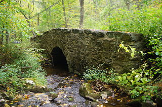
The Frog Hollow Road Bridge is a historic stone arch bridge that carries Frog Hollow Road over a minor tributary of the South Branch Raritan River in Tewksbury Township of Hunterdon County, New Jersey, United States. Built between 1860 and 1873, it was added to the National Register of Historic Places on December 12, 2002, for its significance in engineering and transportation. It was listed as part of the Historic Bridges of Tewksbury Township, Hunterdon County, New Jersey Multiple Property Submission (MPS).
The Hollow Brook Road Bridge is a historic truss bridge that carries Hollow Brook Road over a tributary of the Lamington River in Tewksbury Township of Hunterdon County, New Jersey, United States. Built around 1880, the steel bridge was added to the National Register of Historic Places on December 12, 2002, for its significance in engineering and transportation. It was listed as part of the Historic Bridges of Tewksbury Township, Hunterdon County, New Jersey Multiple Property Submission (MPS).


