
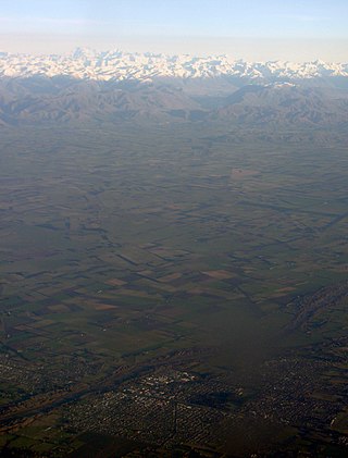
The Rangitata River is one of the braided rivers of the Canterbury Plains in southern New Zealand. It flows southeast for 120 kilometres (75 mi) from the Southern Alps, entering the Pacific Ocean 30 kilometres (19 mi) northeast of Timaru. The river has a catchment area of 1,773 square kilometres (685 sq mi), and a mean annual flow of 95 cubic metres per second (3,400 cu ft/s) at Klondyke.
Rangitata Island was a long lens-shaped island in the delta of the braided Rangitata River in Canterbury, New Zealand, approximately halfway between Timaru and Ashburton, New Zealand. The island was approximately 17 kilometres (11 mi) long and about 5 kilometres (3 mi) wide at its widest. Low lying, the area is mostly fertile farmland.

South Canterbury is the area of the Canterbury Region of the South Island of New Zealand bounded by the Rangitata River in the north and the Waitaki River to the south. The Pacific Ocean and ridge of the Southern Alps form natural boundaries to the east and west respectively. Though the exact boundaries of the region have never been formalised, the term is used for a variety of government agencies and other entities. It is one of four traditional sub-regions of Canterbury, along with Mid Canterbury, North Canterbury, and Christchurch city.
Mid Canterbury is a traditional, semi-official subregion of New Zealand's Canterbury Region extending inland from the Pacific coast to the Southern Alps. It is one of four traditional sub-regions of Canterbury, along with South Canterbury, North Canterbury, and Christchurch City.
The Hinds River is a river in the Canterbury region of New Zealand. Its north and south branches drain the eastern flank of the Moorhouse Range, part of the Southern Alps, and their confluence is near Anama and Mayfield. The river then flows across the Canterbury Plains towards the Pacific Ocean, passing through the small town of Hinds along the way. In Hinds, State Highway 1 and the Main South Line railway cross the river. The river's mouth is located between the localities of Longbeach and Lowcliffe.
Wheatstone is a locality in the Canterbury region of New Zealand's South Island. It is located on the Canterbury Plains south of Ashburton, on the banks of the Ashburton River / Hakatere. Other nearby settlements include Huntingdon to the north, Eiffelton and Flemington to the west, Ashton and Waterton to the south, and Riverside and Wakanui to the east on the opposite side of the Ashburton River / Hakatere. Wheatstone is slightly inland from the coastline of the Pacific Ocean.

Rangitata is an electorate in the South Island of New Zealand. It first existed for two parliamentary terms in the late 19th century and was re-established for the 2008 general election. It largely replaced the Aoraki electorate, but included parts of the Rakaia electorate as well.
The New Zealand Fighter Pilots Museum was an aerospace museum located at Wānaka Airport on New Zealand's South Island. It closed in March 2011 and was replaced in December 2011 by the Warbirds & Wheels museum of military aircraft as well as classic and vintage automobiles and motorcycles.
State Highway 78 is a New Zealand State Highway connecting central Timaru with its port. It holds the record for New Zealand's shortest state highway, with a length of just over 900 metres (3,000 ft).
State Highway 71 is a New Zealand state highway connecting Kaiapoi/Christchurch with Rangiora.

RMS Rangitata was an ocean passenger liner that was built in Scotland in 1929 and scrapped in Yugoslavia in 1962. She was operated by the New Zealand Shipping Company between London and Wellington, New Zealand, via the Panama Canal with her two sister ships Rangitiki and Rangitane.

The Lawrence River is a river of inland Canterbury in New Zealand's South Island. One of the headwaters of the Rangitata River system, it flows south from its source north of Mount Arrowsmith, before joining with the Clyde River and Havelock River to become the Rangitata.

The Ashburton River / Hakatere is a river in the Canterbury region of New Zealand, flowing across Mid Canterbury from the Southern Alps to the Pacific Ocean. The official name of the river was amended to become a dual name by the Ngāi Tahu Claims Settlement Act 1998. It has been identified as an Important Bird Area by BirdLife International because it supports breeding colonies of the endangered black-billed gull.

Rangitata is a settlement in New Zealand. It is located at the junction of State Highway 1 and State Highway 79. The Rangitata River is located 3 kilometres north of the town and 10.7 kilometres north of Orari.
Gapes Valley is a valley in the Canterbury Region in the South Island of New Zealand. It is about 6 kilometres (3.7 mi) west of Geraldine and located on the Geraldine Fairlie Highway. The valley is nestled between the Waitohi Hill and the Rocky Ridges and is described as being 4 miles (6.4 km) long with the flat land of exceptional quality. Today Gapes Valley consists of a sparse grouping of houses, the hall and a recently established brewery.

The RangitataGorge is a gorge located in the Canterbury High Country in the South Island of New Zealand. The narrow gorge links the headwaters of the Rangitata River with the fertile Canterbury Plains. The Rangitata gorge is commercially rafted by a local company. It is also a popular river for visiting kayakers, fishermen and adventurist locals in jet boats. The gorge is a class IV to V+ depending on the flow of the river and home to the notable rapids including Rooster's Tail, Pencil Sharpener, The Pinch, Pigs Trough and Hells Gate.

Hakatere Conservation Park is a protected area between the Rakaia River and the Rangitata River in the Ashburton District of New Zealand. The park was established in 2007. It covers 60,000 hectares of rugged mountains and mountain basins, tussocklands and beech forest. It includes the Ashburton Lakes, such as Lake Heron and Lake Clearwater, popular tramping area Mount Somers / Te Kiekie, and Mount Hutt skifield. The closest town is Mount Somers.
Aigantighe Art Gallery is an art gallery located in Timaru, New Zealand. It was established in 1956 and holds the South Island's third-largest public art museum collection. It also features a sculpture garden with work from New Zealand and international sculptors.
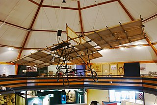
South Canterbury Museum is a museum located in Timaru, New Zealand and owned by the Timaru District Council. Its collections include natural history specimens, Māori artefacts, European settlement and recent social history and documentary history. The museum houses a replica of the aeroplane local inventor Richard Pearse built and experimented with.
