
The Battle of Seven Oaks was a violent confrontation in the Pemmican War between the Hudson's Bay Company (HBC) and the North West Company (NWC), rivals in the fur trade, that took place on 19 June 1816, the climax of a long dispute in western Canada. The Métis people fought for the North West Company, and they called it "the Victory of Frog Plain".
The Dominion Land Survey is the method used to divide most of Western Canada into one-square-mile (2.6 km2) sections for agricultural and other purposes. It is based on the layout of the Public Land Survey System used in the United States, but has several differences. The DLS is the dominant survey method in the Prairie provinces, and it is also used in British Columbia along the Railway Belt, and in the Peace River Block in the northeast of the province.

Radisson is a provincial electoral division in the Canadian province of Manitoba. It was created by redistribution in 1957, and has formally existed since the 1958 provincial election. The riding is located in the northeastern section of the City of Winnipeg and is named after Pierre-Esprit Radisson, a seventeenth-century explorer.
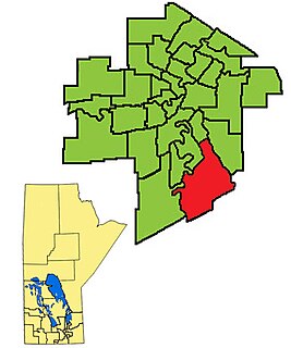
Seine River is a provincial electoral division in the Canadian province of Manitoba. It was created by redistribution in 1989, and has formally existed since the 1990 provincial election. The constituency is located in the southern section of the City of Winnipeg.
Provincial Trunk Highway 59 is a major provincial highway in the Canadian province of Manitoba. It runs from the Lancaster-Tolstoi Border Crossing, through the city of Winnipeg, north to 8th Avenue in Victoria Beach on Lake Winnipeg.

East St. Paul is a rural municipality (RM) in Manitoba, Canada. It is located north-east of and adjacent to the city of Winnipeg, and is part of the Winnipeg Metropolitan Area. The municipality was formed on 3 November 1915 when the municipality of St. Paul (1888-1914) was subdivided into West St. Paul and East St. Paul, with the Red River acting as the dividing line. It encompasses 41 square kilometres (16 sq mi).

Route 150, locally known as St. Anne's Road, is a major arterial route in Winnipeg, Manitoba, Canada.
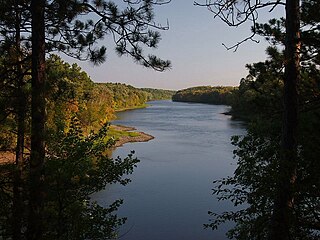
Crow Wing State Park is a state park of Minnesota, United States, at the confluence of the Mississippi and Crow Wing Rivers. The park interprets the site of Old Crow Wing, one of the most populous towns in Minnesota in the 1850s and 1860s. The entire park was added to the National Register of Historic Places in 1970. A section of the Red River Trails that passed through Old Crow Wing is also separately listed on the National Register.

The Eastman Region--also known as Division No. 1-- is located in the south-eastern corner of the Canadian province of Manitoba. It is bounded on the north by the Winnipeg River and Lake Winnipeg, on the east by the Manitoba-Ontario border, on the south by the Canada–US border and on the west by the Red River. It is bordered on the north by the Northern Region, on the east by Northwestern Ontario on the south by the state of Minnesota, on the west by the Pembina Valley Region and the Interlake Region.
A block settlement is a particular type of land distribution which allows settlers with the same ethnicity to form small colonies.

St. Norbert is a bilingual neighbourhood in the southernmost part of Winnipeg, Manitoba, Canada. While outside the Perimeter Highway,, it is still part of the city. At the 2016 Census, the population of St. Norbert is 5,850.
St. Malo is an unincorporated community recognized as a local urban district located in the Rural Municipality of De Salaberry, approximately 70 km south of The Forks, Winnipeg, Manitoba. Most of the community's residents are bilingual francophone of Métis or Québécois heritage.
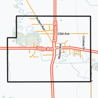
St-Pierre-Jolys, pop. 1,170 is a village 50 km (31 mi) south southeast of Winnipeg on Highway 59 near the Rat River, in the Canadian province of Manitoba. It is surrounded by the Rural Municipality of De Salaberry. The nearest communities are Steinbach, St. Malo, Morris and Niverville.

James McKay was a fur trader, pioneer and pre Canadian confederation politician and interpreter.

Old Crow Wing is a ghost town in Fort Ripley Township, Crow Wing County, Minnesota, United States, at the confluence of the Mississippi and Crow Wing rivers. Long occupied by the Ojibwe people, for over a century it was also the northernmost European-American settlement on the Mississippi.
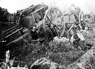
The Red River Trails were a network of ox cart routes connecting the Red River Colony and Fort Garry in British North America with the head of navigation on the Mississippi River in the United States. These trade routes ran from the location of present-day Winnipeg in the Canadian province of Manitoba across the Canada–United States border, and thence by a variety of routes through what is now the eastern part of North Dakota and western and central Minnesota to Mendota and Saint Paul, Minnesota on the Mississippi.

Central Park is a large urban park located in Downtown Winnipeg, and forms the heart of the neighbourhood of the same name. The area is bound by Notre Dame Ave. to the north, Ellice Ave. to the south, Donald St. to the east and Balmoral St. to the west. Everything within the neighbourhood's one-kilometre loop can be reached within eight minutes on foot. The neighbourhood is home to the largest concentration of Black Canadians in Manitoba, mostly African immigrants and refugees. 70 per cent of all refugees coming to Winnipeg live downtown, largely settling in and around the Central Park area.
Varennes is a neighbourhood in the city of Winnipeg, Manitoba, Canada. It is a small triangular neighbourhood located in the northern section of the district of St. Vital, and is bounded by St. Mary's Road on the west, Fermor Avenue on the south, and St. Anne's Road on the east. At the 2001 census, Varennes had a population of 1,080.

The Rat River is a tributary of the Red River of the North in southern Manitoba, Canada. It is part of the watershed of Hudson Bay.
Provincial Road 246 is a provincial road in the Canadian province of Manitoba. It runs from PR 200 near Ste. Agathe to PTH 75 at St. Jean Baptiste.