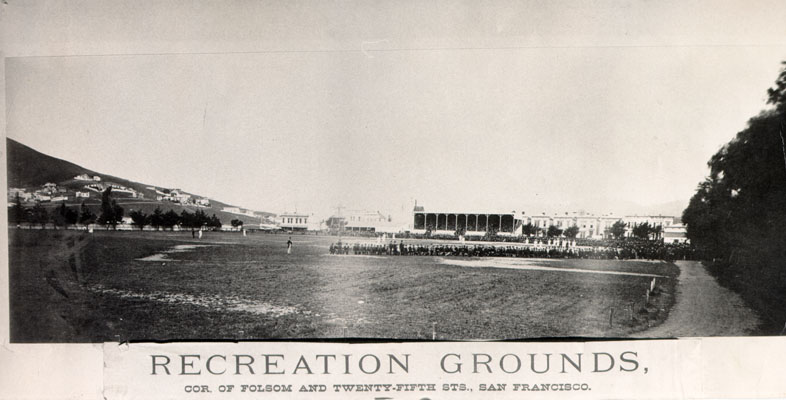
Recreation Park (San Francisco)

Last updated

Recreation Park was the name applied to several former baseball parks in San Francisco, California in the late 19th century and early 20th century.

Contents

Recreation Grounds, opened on November 26, 1868, and operated until May 1884, and was San Francisco's first professional enclosed ballpark. Located at the terminus of a railcar line in San Francisco's heavily Irish Mission District, at the present day Garfield Square. [1] [2] The ballpark was bordered by the streets Harrison, Twenty-Sixth, Folsom and Twenty-Fifth. [3] The opening day ceremonies included the second game of the California baseball championship series between the Oakland Wide Awakes and the San Francisco Eagles, who won by the score of 37–23. The day's festivities included an operatic concert and footraces and were attended by a crowd of 4,000 people. [4] 37°45′1.78″N122°24′47.78″W / 37.7504944°N 122.4132722°W / 37.7504944; -122.4132722 Photo.

Haight-Street Recreation Grounds 1886 [5] -1895. Another recreation grounds existed in the Haight, with ownership transferred to J.B. Gilbert of the Central league on September 8, 1893. [6] and was also referred to as Haight-Street Recreation Park located between Stanyan, Waller, Cole and Frederic Streets was closed in 1895. [7]

Central Park, also sometimes called Recreation Park, seating capacity of 15,000, opened on Thanksgiving Day of 1884 [8] and operated until 1906. [9] Located at 8th Street and Market Streets, was used by several clubs including the San Francisco Seals of the Pacific Coast League from 1903. Destroyed by the earthquake and fire on April 18, 1906. The Seals temporarily moved to Oakland while the city of San Francisco was being rebuilt. Photo.

Recreation Park opened in September 1897 for local baseball and football. An early event was the Cal-Stanford Big Game that November. The hastily constructed stands suffered a partial collapse, but there were no fatalities. The following spring, the San Francisco Olympics, also known as the Athletics and the Brewers, began operating in the California League. The ball club lasted through the 1901 season. In 1903, the San Francisco Seals began their long run in the Pacific Coast League. They played at this ballpark until the 1906 San Francisco earthquake put them out of business for a while.

The ballpark was located on a block bounded by 8th Street (northeast, first base); Harrison Street (southeast, third base); Gordon Street (southwest, left field); and Ringold Street (northwest, right field).

1907 advertisement New York Giants vs SF Seals.png
1907 advertisement

Recreation Park, located in the Mission District 37°46′1.87″N122°25′23.93″W / 37.7671861°N 122.4233139°W / 37.7671861; -122.4233139 , was the best known and longest-lived of these ballparks. It was the home of the Seals during 1907–13 and then 1915–30 after a one-year experiment playing at newly built Ewing Park near the Richmond District. The experiment was a fiasco, largely because of the cold and foggy summer weather endemic to western San Francisco. The Oaks, in turn, had essentially moved into Recreation Park in 1907 and played most of their games there (except Thursdays and Sunday mornings) until their new Oaks Park was opened in 1913, although they continued to play some games in San Francisco until sometime in the 1920s. This congenial arrangement was made easier by the fact that J. Cal Ewing, founding father of the PCL, owned both clubs for their first couple of decades. The ballpark sat 15,000. It also become the home of the Mission Reds (a.k.a. "Missions") upon their arrival in 1926.

The Chicago White Sox held spring training at Recreation Park in 1909 and 1910. [10] [11]

This final incarnation of Recreation Park was on a block bounded by 14th Street (north, right field); Valencia Street (east, first base); 15th Street (south, third base); and Guerrero Street (west, left field) 37°46′2.7″N122°25′23.32″W / 37.767417°N 122.4231444°W / 37.767417; -122.4231444 . The stands were an unusual design, with a small lower deck topped directly above (thus protected from the weather) by a large upper deck, much of which was unroofed and open to the sunshine and the elements. The stands were also made of wood. A new, concrete ballpark called Seals Stadium, less than a mile east of Recreation Park, opened in 1931 as the new home of both the Seals and the Missions. Recreation Park was demolished and the site was converted into a public housing project.

The Recreation Grounds in the Mission, which operated from 1868 - 1884. Located where Garfield Park sits today at 25th & Harrison Streets Recreation Grounds Ballpark 25th & Folsom 1875.jpg
The Recreation Grounds in the Mission, which operated from 1868 - 1884. Located where Garfield Park sits today at 25th & Harrison Streets

See also

Related Research Articles

<span class="mw-page-title-main">Seals Stadium</span> Minor league baseball stadium in San Francisco (1931–1959)

Seals Stadium was a minor league baseball stadium on the west coast of the United States, located in San Francisco, California; it later became the first home of the major league San Francisco Giants. Opened in the Mission District in 1931, Seals Stadium was the longtime home of the San Francisco Seals (1931–57) of the Pacific Coast League. The PCL's Mission Reds (1931–37) shared the ballpark with the Seals for the first seven years, then moved to Los Angeles and became the Hollywood Stars.

<span class="mw-page-title-main">South End Grounds</span> Baseball parks in Boston, Massachusetts

South End Grounds refers to any one of three baseball parks on one site in Boston, Massachusetts. They were home to the franchise that eventually became known as the Boston Braves, first in the National Association and later in the National League, from 1871 to 1914.

<span class="mw-page-title-main">Duboce Triangle, San Francisco</span> Neighborhood in San Francisco, California, United States

The Duboce Triangle is a neighborhood of San Francisco, California, located below Buena Vista Park and between the neighborhoods of the Castro/Eureka Valley, the Mission District, and the Lower Haight.

The Bank Street Grounds is a former baseball park located in Cincinnati. The park was home to three major league baseball teams. The National League Cincinnati Stars club in 1880, the current Cincinnati Reds franchise from 1882 to 1883 and the Cincinnati Outlaw Reds of the Union Association in 1884. It succeeded the Avenue Grounds as the home site for professional ball in the Queen City.

<span class="mw-page-title-main">Ridgewood Park (baseball ground)</span> Baseball ground in Queens, New York, US

Ridgewood Park, also known as Wallace's Ridgewood Park or the Wallace Grounds, and frequently confused with Grauer's Ridgewood Park, was a baseball ground in Ridgewood, Queens, New York. Both Wallace's and Grauer's are shown in Belcher Hyde's Map of Newtown in 1915. The baseball field was part of a larger entertainment area bounded Wyckoff Avenue, Covert Street, Halsey Street, and Irving Avenue. The baseball field was southwest of the Long Island Rail Road's Montauk Branch tracks. Eldert Street, although depicted on the map as running through the baseball grounds, was not cut through southwest of the railroad tracks and the road remains interrupted there today. Originally the park was in Queens County, before its incorporation into New York City in 1899. This facilitated Sunday baseball playing, including the charging of admission, beyond the reach of Sabbath enforcers from the then-city of Brooklyn.

<span class="mw-page-title-main">Panhandle (San Francisco)</span> Linear park in the California city

The Panhandle is a public park in San Francisco, California, so named because it forms a panhandle with Golden Gate Park. It is long and narrow, being three-quarters of a mile long and just one block wide. Fell and Oak Streets border it to the north and south, Baker Street to the east, and to the west Stanyan Street which separates the smaller Panhandle from the much larger Golden Gate Park. The Panhandle is bisected by Masonic Avenue, which runs north to south and cuts through the middle of the park. In its westernmost block, Oak and Fell Streets angle across the Panhandle, converge with one another, and continue west of Stanyan as John F. Kennedy Drive and Kezar Drive.

<span class="mw-page-title-main">Cole Valley, San Francisco</span> Neighborhood of San Francisco

Cole Valley is a small neighborhood in San Francisco, California. It borders Golden Gate Park to the north, Haight-Ashbury to the northeast, The Castro to the east. and Twin Peaks to the south. Near Kezar Stadium, Cole Valley is the smallest neighborhood in the city.

<span class="mw-page-title-main">Oaks Park (stadium)</span>

<span class="mw-page-title-main">Boston Reds (Union Association)</span>

The Boston Reds of 1884 were a professional baseball team that competed in the short-lived Union Association.

<span class="mw-page-title-main">The Wiggle</span> Bycicle route in San Francisco

Haight Street Grounds was one of San Francisco's earliest baseball parks; it was also used for college football. It opened in 1887 and was demolished in 1895.

<span class="mw-page-title-main">Edmonds Field</span>

Edmonds Field was home to the Sacramento Solons, the Pacific Coast League AAA team from 1910 through 1960, after which they moved to Hawaii. The field was located at the southeast corner of Broadway to the north ; Riverside Boulevard to the west ; and First Avenue to the south.

<span class="mw-page-title-main">Garfield Square</span>

<span class="mw-page-title-main">Clark Field (1928)</span>

Clark Field was a baseball park in Austin, Texas, used primarily by the University of Texas Longhorns. The field was used from 1928 until 1974. It is considered one of the most novel ballparks ever conceived thanks to its location. There was a limestone cliff in the outfield that created havoc for outfielders and made baseball games exciting. It was replaced by UFCU Disch-Falk Field in 1975.

Athletic Park was a ballpark in Los Angeles, California, United States. Tenants include the Los Angeles Seraphs, Los Angeles Angels. It was the site of the first professional night game on the Pacific coast, which took place on July 2, 1893.

Indianapolis Park or Athletic Park (II) was a baseball ground in Indianapolis, Indiana. It was the Sunday home field of the Indianapolis Hoosiers baseball club of the National League from 1888 to 1889.

<span class="mw-page-title-main">Ewing Field</span>

Ewing Field was a baseball park in San Francisco, California. It served as the home of the San Francisco Seals of the Pacific Coast League for a single season, 1914.

Vinton Street Park was one of the most common names for the professional baseball park in Omaha, Nebraska from 1900 through 1936. It was destroyed by fire, and eleven years passed before Omaha acquired a professional ball club again.

References

  1. "The San Francisco Call newspaper, July 7, 1907". 7 July 1907. p. 4. Retrieved 2009-09-05.
  2. "Sacramento daily record-union newspaper. (Sacramento [Calif.]) May 9, 1884". 9 May 1884. p. 5. Retrieved 2009-09-05.
  3. Zingg, Paul J.. Harry Hooper: An American Baseball Life Sport and Society, Page 46, University of Illinois Press, 2004 ISBN   978-0-252-07170-6
  4. "Daily Alta California - November 27, 1868".
  5. FoundSF.org
  6. "The San Francisco Morning Call, September 9, 1893". 9 September 1893. p. 8. Retrieved 2009-09-05.
  7. "The San Francisco Morning Call newspaper, March 1, 1895". March 1895. p. 11. Retrieved 2009-09-05.
  8. Daily Alta California newspaper, Volume 37, Number 12601, pg 8, 13 October 1884
  9. Franks, Joel (2001). Whose baseball?: the national pastime and cultural diversity in California, 1859-1941. Issue 19 of American sports history series. Scarecrow Press. p. 56. ISBN   9780810839274.
  10. "The Baseball Guru - MLB SPRING TRAINING LOCATIONS BY FRANCHISE SINCE 1900 by Kevin Saldana".
  11. Fountain, Charles (2009). Under the March Sun: The Story of Spring Training . Oxford University Press, USA. pp.  269. ISBN   978-0-19-537203-8.

Further reading