
Whatcom Peak is in North Cascades National Park in the U.S. state of Washington. Whatcom Peak is .50 mi (0.80 km) north of Challenger Glacier and the Whatcom Glacier descends from the northeast slopes of the peak. An unnamed hanging glacier descends along the northwest flank of the peak. This mountain is set between Mount Challenger and Easy Peak.

Azurite Peak is an 8,434-foot (2,571-metre) double-summit mountain located at the common boundary point of Okanogan County, Skagit County, and Whatcom County in Washington state. It is part of the Okanogan Range which is a sub-range of the North Cascades Range. Azurite Peak ranks as the 81st-highest summit in the state. Azurite Peak is situated north of Azurite Pass on land administered by the Okanogan–Wenatchee National Forest. The nearest higher neighbor is Tower Mountain, 5.24 miles (8.43 km) to the south-southeast, and Mount Ballard lies 1.97 miles (3.17 km) to the north. Remnants of a small pocket glacier are found on the east aspect. Precipitation runoff from the peak drains north into tributaries of the Skagit River, and south into the Methow River. Topographic relief is significant as the summit rises over 3,000 feet above Mill Creek in one mile (1.6 km). The Pacific Crest Trail traverses the base of Azurite Peak.

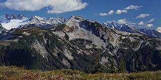
Elephant Butte is a remote 7,380-foot-elevation summit located in Whatcom County of Washington, United States. It is situated within North Cascades National Park and Stephen Mather Wilderness, and is part of the Picket Range, a subset of the North Cascades. Like many North Cascades peaks, Elephant Butte is more notable for its large, steep rise above local terrain than for its absolute elevation. Topographic relief is significant as the north aspect rises 5,200 feet above McMillan Creek in one mile, and the south aspect rises 5,000 feet above Stetattle Creek in two miles. Precipitation runoff from the mountain drains to the Skagit River via these two creeks. This geographical feature's name has been officially adopted by the United States Board on Geographic Names.

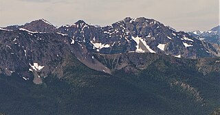
Mount Ballard is an 8,371-foot (2,551-metre) double-summit mountain located in eastern Whatcom County of Washington state. It is part of the Okanogan Range which is a sub-range of the North Cascades Range, and the mountain is situated on land administered by the Okanogan–Wenatchee National Forest. Ballard ranks 84th on Washington's highest 100 peaks. The nearest higher neighbor is Azurite Peak, 2.04 miles (3.28 km) to the south. Precipitation runoff from Mount Ballard drains into Mill Creek and Slate Creek, both tributaries of the Skagit River. Topographic relief is significant as the summit rises approximately 4,000 feet above Mill Creek in one mile (1.6 km).

Castle Peak is a prominent 8,343-foot (2,543-metre) mountain summit located in the Hozameen Range of the North Cascades, on the shared border between Okanogan County and Whatcom County of Washington state. The mountain is situated one mile (1.6 km) south of the Canada–United States border, on the Cascade crest, in the Pasayten Wilderness, on land managed by the Okanogan–Wenatchee National Forest. The nearest higher peak is Jack Mountain, 14.8 miles (23.8 km) to the south-southwest. Castle Peak is the second highest summit of the Hozameen Range following Jack Mountain. Castle Peak is the sixth-highest mountain in the Pasayten Wilderness. Precipitation runoff from the mountain drains east into Castle Creek, a tributary of the Similkameen River, or west into tributaries of the Skagit River. Topographic relief is significant as the summit rises nearly 3,000 feet above Crow Creek in 0.75 mile (1.2 km).

Skagit Peak is a 6,824-foot (2,080-metre) mountain summit located in the North Cascades, in Whatcom County of Washington state. It is situated on the western side of the Cascade crest, at the western edge of the Pasayten Wilderness, on land managed by the Okanogan–Wenatchee National Forest. Skagit Peak is part of the Hozameen Range, a subset of the North Cascades which also includes Hozomeen Mountain to the north, and Jack Mountain to the south. Precipitation runoff from this mountain drains into the Skagit River via Three Fools Creek and Ross Lake.

Spratt Mountain is a 7,258-foot (2,212-metre) mountain summit located in the North Cascades, in Whatcom County of Washington state. It is situated on the western side of the Cascade crest, at the western edge of the Pasayten Wilderness, on land managed by the Okanogan–Wenatchee National Forest. Spratt Mountain is part of the Hozameen Range, a subset of the North Cascades which also includes Skagit Peak four miles to the north, and Jack Mountain six miles to the south. Precipitation runoff from this mountain drains into Ross Lake via Three Fools Creek and Dry Creek.

Indian Mountain is a remote 7,133-foot (2,174-metre) mountain summit in the Skagit Range of the North Cascades, in Whatcom County of Washington state. Indian Mountain is situated in North Cascades National Park, seven miles (11 km) south of the Canada–United States border. The nearest higher neighbor is Red Face Mountain, 1.14 mi (1.83 km) to the southeast, and Whatcom Peak rises 2.9 mi (4.7 km) to the south. Although modest in elevation, relief is significant since this peak rises over 4,100 feet above Brush Creek Valley in approximately one mile. Precipitation runoff from Indian Mountain drains into tributaries of the Chilliwack River.
Easy Peak is a 6,613-foot (2,016-metre) mountain summit in the Skagit Range of the North Cascades, in Whatcom County of Washington state. Easy Peak is situated in North Cascades National Park, and is often climbed during the Easy Ridge approach to Mount Challenger and the remote northern Pickets. The nearest higher neighbor is Mineral Mountain, 2 mi (3.2 km) to the west, and Whatcom Peak is set 2.1 mi (3.4 km) to the east. Glacierets line the north slope of Easy Ridge between Easy Peak and Whatcom Peak. Precipitation runoff from this peak drains north into the Chilliwack River, or south into headwaters of the Baker River.
Yellow Aster Butte is a 6,241-foot (1,902-metre) Skagit Range summit located three miles south of the Canada–United States border, in Whatcom County of Washington state. It is situated within the Mount Baker Wilderness, on land managed by Mount Baker-Snoqualmie National Forest. The nearest higher neighbor is Winchester Mountain, 1.77 miles (2.85 km) to the east, and Mount Larrabee is set 2.3 miles (3.7 km) to the northeast. The summit offers views of Mount Larrabee, Tomyhoi Peak, American Border Peak, Canadian Border Peak, Mount Shuksan, and Mount Baker. Precipitation runoff on the north side of the mountain drains into Tomyhoi Creek, whereas the west side of the mountain drains into Damfino Creek, and the south slope is drained by Swamp Creek.

Rhino Butte is a remote 6,914-foot-elevation summit located in Whatcom County of Washington, United States. It is situated within North Cascades National Park and Stephen Mather Wilderness, and is part of the Picket Range, a subset of the North Cascades. Like many North Cascades peaks, Rhino Butte is more notable for its large, steep rise above local terrain than for its absolute elevation. Topographic relief is significant as the north aspect rises 4,350 feet above McMillan Creek in one mile, and the south aspect rises 4,700 feet above Stetattle Creek in two miles. Precipitation runoff from the mountain drains to the Skagit River via these two creeks. The nearest higher neighbor is Elephant Butte, 1.27 mile to the east-northeast, with Hippo Butte (6,889 ft) between the two. A high alpine ridge connects Rhino to McMillan Spire, 1.7 mile to the west-southwest, and Azure Lake lies below this ridge. The first ascent of the summit was made October 15, 1978, by John Roper. This geographical feature's name has not yet been officially adopted by the United States Board on Geographic Names.

North Big Bosom Butte is a 6,384-foot (1,946-metre) mountain summit located in Whatcom County of Washington state.
Mount Watson is a 6,220-foot-elevation (1,900-meter) summit located in the North Cascades, in Whatcom County of Washington state.
Mount Ann is a 5,840-foot-elevation (1,780-meter) mountain summit located in the North Cascades in Whatcom County of Washington state. It is set within the Mount Baker Wilderness, on land managed by Mount Baker-Snoqualmie National Forest, and is only one mile outside the boundary of North Cascades National Park. Mount Ann is situated immediately southwest of line parent Mount Shuksan and northeast of Mount Baker. Mount Ann can be seen south of Artist Point which is at the end of the Mount Baker Highway. Precipitation runoff from the mountain drains into Swift Creek and Shuksan Creek, which empty into Baker Lake. Topographic relief is significant as the west aspect rises 3,200 feet above Swift Creek in approximately one mile. The mountain is unofficially named in association with nearby Lake Ann. Due to its proximity to the Mt. Baker Ski Area, Mount Ann is a winter destination for skiing and snowshoeing.

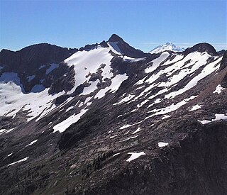
Glee Peak is a 7,180-foot-elevation (2,190-meter) mountain summit located in Whatcom County of Washington state, United States. It is set within North Cascades National Park and Stephen Mather Wilderness, where it is situated 1.7 mile north of The Roost and one mile south of Azure Lake. The nearest higher neighbor is McMillan Spire, 1.7 miles (2.7 km) to the north-northwest. Glee Peak is part of the Picket Range which is a sub-range of the North Cascades, and like many North Cascades peaks, it is more notable for its large, steep rise above local terrain than for its absolute elevation. Topographic relief is significant as the northeast aspect rises 4,000 feet above Stetattle Creek in approximately one mile, and the southwest aspect rises 6,000 feet above Goodell Creek in three miles. Precipitation runoff from the mountain drains into these two creeks which are both tributaries of the Skagit River. Who made the first ascent of the summit is unknown, but Glee Davis and Burton Babcock were climbing in the immediate area as early as 1905.
Majestic Mountain is a 7,530-foot-elevation (2,295-meter) mountain summit located in Whatcom County in Washington state.

Damnation Peak is a 5,635-foot-elevation (1,718 m) mountain summit located in the North Cascades of Washington state. It is situated within North Cascades National Park, Stephen Mather Wilderness, and Whatcom County. Like many North Cascades peaks, Damnation Peak is more notable for its large, steep rise above local terrain than for its absolute elevation. Topographic relief is significant as the south aspect rises 2,800 feet above Damnation Creek in approximately 1.5 mile, and the north aspect rises 3,000 feet above Triumph Creek in one mile. Precipitation runoff from the mountain drains into these tributaries of the Skagit River. Neighbors include Mount Triumph, 2.8 miles (4.5 km) to the north-northeast, and Trappers Peak is 2.8 miles (4.5 km) to the east-northeast. The town of Newhalem is six miles to the east. In 1938, Lloyd Anderson climbed a nearby summit which is known today as Thornton Peak and called it "Damnation."
Middle Peak is a 7,464-foot-elevation (2,275-meter) mountain summit located in the North Cascades in Whatcom County of Washington state, United States.
Baby Munday Peak is a 2,250-meter-elevation (7,382-foot) mountain summit located in the Cheam Range of British Columbia, Canada.
Tamarack Peak is a 7,290-foot (2,222-metre) mountain summit located on the border shared by Okanogan County and Whatcom County in Washington state.


