The Churchill River is a major river in Alberta, Saskatchewan and Manitoba, Canada. From the head of the Churchill Lake it is 1,609 kilometres (1,000 mi) long. It was named after John Churchill, 1st Duke of Marlborough and governor of the Hudson's Bay Company from 1685 to 1691.

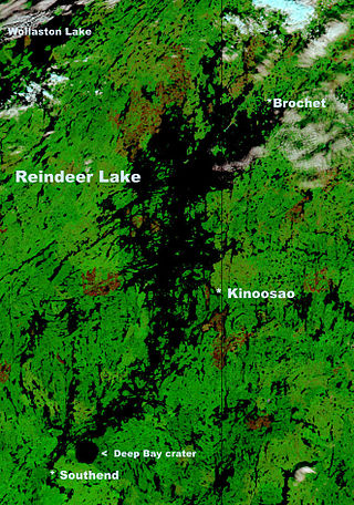
Reindeer Lake is a lake in Western Canada located on the border between north-eastern Saskatchewan and north-western Manitoba, with the majority in Saskatchewan. The name of the lake appears to be a translation of the Algonquian name. It is the 24th largest lake in the world by area, as well as being the second-largest lake in Saskatchewan and the ninth largest in Canada. Eight percent of the lake lies in Manitoba while 92% of the lake is in Saskatchewan.

Southend is a community in north-eastern Saskatchewan, Canada located at the southern end of Reindeer Lake, the ninth largest lake in Canada. The community is the terminus of Highway 102 and is about 221 kilometres (137 mi) north-east of La Ronge.
Cree Lake/Crystal LodgeAerodrome is located adjacent to Crystal Lodge, a fly-in fishing lodge on Cree Lake, Saskatchewan, Canada. The airport is located on Ispatinow Island, the largest island in the lake.
Key Lake Airport is a regional airport near the Key Lake mine in Saskatchewan, Canada.
Malcolm Island Airport is a registered aerodrome located on Hydiak Island, Reindeer Lake, Saskatchewan, Canada.
Wollaston Lake Airport is located adjacent to Wollaston Lake, Saskatchewan, Canada on the Hatchet Lake Dene Nation.

Regina Beach is a town in south central Saskatchewan, located on Highway 54, close to where Highway 11 intersects with the Qu'Appelle Valley.
Hatchet Lake Airport is located near Hatchet Lake, Saskatchewan, Canada.

Wollaston Lake is a lake in north-eastern part of the Canadian province of Saskatchewan. It is about 550 kilometres (340 mi) north-east of Prince Albert. With a surface area of 2,286 square kilometres (883 sq mi), it is the largest bifurcation lake in the world – that is, a lake that drains naturally in two directions.
Highway 995, also known as Welcome Street, is a provincial highway in the far north region of the Canadian province of Saskatchewan. It is one of the few highways in Saskatchewan that is completely isolated from the other highways. Seasonal access is provided to Highway 905 by way of the Wollaston Lake Barge.
Highway 994 is a provincial highway in the far north region of the Canadian province of Saskatchewan. It is one of the province's shortest highways at about 1.1 kilometres (0.68 mi) long. The highway provides access to the isolated community of Kinoosao. Due to its geographic location, it is the only provincial highway in Saskatchewan that requires entering the neighbouring province of Manitoba to travel it. The route begins at the shores of Reindeer Lake in Kinoosao and heads east a short distance to the provincial line, where it continues eastward as Manitoba Provincial Road 394 towards Lynn Lake, Manitoba.
Highway 954 is a provincial highway in the Canadian province of Saskatchewan. It runs from Highway 26 on the north side of Goodsoil to a dead end at Northern Cross Resort on Lac des Îles within Meadow Lake Provincial Park. At the eastern end of the highway is the Goodsoil Airport. It is about 12.9 kilometres (8.0 mi) long.
Goodsoil is a village in the Canadian province of Saskatchewan within the Rural Municipality of Beaver River No. 622 and Census Division No. 17. The Goodsoil Historical Museum Site is a municipal heritage property on the Canadian Register of Historic Places. It is the western gateway to Meadow Lake Provincial Park.

Meadow Lake Provincial Park is a northern boreal forest provincial recreational park along the Waterhen and Cold Rivers in the Canadian province of Saskatchewan. The park was founded on 10 March 1959, is the largest provincial park in Saskatchewan, and encompasses over 25 lakes in an area of 1,600 km2 (620 sq mi). The park was named "Meadow Lake" after the city of Meadow Lake and Meadow Lake. The city and the lake are not in the park and are located about 40 kilometres (25 mi) south-east of the nearest park entrance, which is about 5 kilometres (3.1 mi) north of Dorintosh. The length of the park stretches about 113 kilometres (70 mi) from Cold Lake on the Saskatchewan / Alberta border in the west to the eastern shore of Waterhen Lake in the east.
Axe Lake Aerodrome is located near the Axe Lake oil sands discovery in north-west Saskatchewan, Canada. The aerodrome is located near the border with Alberta, just south of Vande Veen Lake. The nearest highway is Highway 955 to the east. A gravel road connects the airport to the highway.
Cree Lake Water Aerodrome is located adjacent to Crystal Lodge, a fly-in fishing lodge on Cree Lake, Saskatchewan, Canada. The airport is located alongside Cree Lake/Crystal Lodge Aerodrome on Ispatinow Island, the largest island in the lake.
Reindeer Lake may refer to:
Seabee Mine Aerodrome is located near Laonil Lake and serves the Seabee Gold Mine in Saskatchewan, Canada.


