Dababa is one of three departments in Hadjer-Lamis, a region of Chad. Its capital is Bokoro.
Polusin is a village in the administrative district of Gmina Świnice Warckie, within Łęczyca County, Łódź Voivodeship, in central Poland. It lies approximately 4 kilometres (2 mi) north-west of Świnice Warckie, 21 km (13 mi) west of Łęczyca, and 50 km (31 mi) north-west of the regional capital Łódź.
Zaborze is a village in the administrative district of Gmina Sadkowice, within Rawa County, Łódź Voivodeship, in central Poland. It lies approximately 10 kilometres (6 mi) east of Sadkowice, 28 km (17 mi) east of Rawa Mazowiecka, and 82 km (51 mi) east of the regional capital Łódź.
Teklin is a village in the administrative district of Gmina Żelechlinek, within Tomaszów Mazowiecki County, Łódź Voivodeship, in central Poland. It lies approximately 6 kilometres (4 mi) east of Żelechlinek, 24 km (15 mi) north of Tomaszów Mazowiecki, and 45 km (28 mi) east of the regional capital Łódź.
Książnice is a village in the administrative district of Gmina Pacanów, within Busko County, Świętokrzyskie Voivodeship, in south-central Poland. It lies approximately 1 kilometre (1 mi) east of Pacanów, 26 km (16 mi) east of Busko-Zdrój, and 63 km (39 mi) south-east of the regional capital Kielce.
Wzory is a village in the administrative district of Gmina Iwaniska, within Opatów County, Świętokrzyskie Voivodeship, in south-central Poland. It lies approximately 2 kilometres (1 mi) south-west of Iwaniska, 15 km (9 mi) south-west of Opatów, and 49 km (30 mi) east of the regional capital Kielce.
Long Lake could mean the following:
Kassa (Ká:dà) is a commune of the Cercle of Koro in the Mopti Region of Mali. Tommo So is spoken in Kassa. Kassa consists of a cluster of about 17 villages, mostly situated on the top of a plateau. The principal village lies at Berdosso. In 1998 the commune had a population of 11,218.
Piękna Góra is a village in the administrative district of Gmina Giżycko, within Giżycko County, Warmian-Masurian Voivodeship, in northern Poland. It lies approximately 3 kilometres (2 mi) south-west of Giżycko and 85 km (53 mi) east of the regional capital Olsztyn.
Złakowo is a village in the administrative district of Gmina Postomino, within Sławno County, West Pomeranian Voivodeship, in north-western Poland. It lies approximately 4 kilometres (2 mi) north of Postomino, 18 km (11 mi) north of Sławno, and 187 km (116 mi) north-east of the regional capital Szczecin.
Donja Presjenica is a village in the municipality of Trnovo, Bosnia and Herzegovina.

Metsküla is a village in Lääneranna Parish, Pärnu County, in western Estonia.
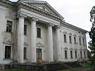
Udriku is a village in Kadrina Parish, Lääne-Viru County, northeastern Estonia, where the Udriku manor, a national architectural monument built in the early nineteenth century, is situated.
Orguse is a village in Väike-Maarja Parish, Lääne-Viru County, in northeastern Estonia.
Gluhavica is a village in the municipality of Tutin, Serbia. According to the 2002 census, the village has a population of 265 people.
Sinja Glava is a village in the municipality of Pirot, Serbia. According to the 2002 census, the village has a population of 138 people.

The location of the geographical centre of Asia depends on the definition of the borders of Asia, mainly whether remote islands are included to define the extreme points of Asia, and on the method of calculating the final result.
