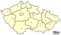
Mikulovice is a village in the Pardubice Region of the Czech Republic. It has roughly 850 inhabitants.
Krzekotówek is a village in the administrative district of Gmina Kotla, within Głogów County, Lower Silesian Voivodeship, in south-western Poland. Prior to 1945 it was in Germany.

Błotnica is a village in the administrative district of Gmina Kondratowice, within Strzelin County, Lower Silesian Voivodeship, in south-western Poland.
Malice is a village in the administrative district of Gmina Werbkowice, within Hrubieszów County, Lublin Voivodeship, in eastern Poland. It lies approximately 5 kilometres (3 mi) south-west of Werbkowice, 15 km (9 mi) south-west of Hrubieszów, and 102 km (63 mi) south-east of the regional capital Lublin.
Pólko is a village in the administrative district of Gmina Michałowo, within Białystok County, Podlaskie Voivodeship, in north-eastern Poland, close to the border with Belarus.
Zwierzyniec is a village in the administrative district of Gmina Busko-Zdrój, within Busko County, Świętokrzyskie Voivodeship, in south-central Poland. It lies approximately 6 kilometres (4 mi) north of Busko-Zdrój and 42 km (26 mi) south of the regional capital Kielce.
Drogowle is a village in the administrative district of Gmina Raków, within Kielce County, Świętokrzyskie Voivodeship, in south-central Poland. It lies approximately 5 kilometres (3 mi) north-west of Raków and 34 km (21 mi) south-east of the regional capital Kielce.
Ulów is a village in the administrative district of Gmina Bałtów, within Ostrowiec County, Świętokrzyskie Voivodeship, in south-central Poland. It lies approximately 4 kilometres (2 mi) south-east of Bałtów, 14 km (9 mi) north-east of Ostrowiec Świętokrzyski, and 69 km (43 mi) east of the regional capital Kielce.

Ərəbşahverdi is a village in the Goychay Rayon of Azerbaijan. The village forms part of the municipality of Mallı-Şıxlı.
Chwałki is a village in the administrative district of Gmina Obrazów, within Sandomierz County, Świętokrzyskie Voivodeship, in south-central Poland. It lies approximately 6 kilometres (4 mi) east of Obrazów, 5 km (3 mi) north-west of Sandomierz, and 80 km (50 mi) east of the regional capital Kielce.
Krzywda is a village in the administrative district of Gmina Stara Błotnica, within Białobrzegi County, Masovian Voivodeship, in east-central Poland. It lies approximately 8 kilometres (5 mi) south of Białobrzegi and 71 km (44 mi) south of Warsaw.
Biskupice is a village in the administrative district of Gmina Drobin, within Płock County, Masovian Voivodeship, in east-central Poland.
Bogumiłów is a village in the administrative district of Gmina Opatówek, within Kalisz County, Greater Poland Voivodeship, in west-central Poland.
Czarnuszka is a village in the administrative district of Gmina Dobrzyca, within Pleszew County, Greater Poland Voivodeship, in west-central Poland. It lies approximately 8 kilometres (5 mi) east of Dobrzyca, 6 km (4 mi) south-west of Pleszew, and 81 km (50 mi) south-east of the regional capital Poznań.
Klawkowo is a village in the administrative district of Gmina Chojnice, within Chojnice County, Pomeranian Voivodeship, in northern Poland. It lies approximately 4 kilometres (2 mi) east of Chojnice and 100 km (62 mi) south-west of the regional capital Gdańsk.
Miętno is a village in the administrative district of Gmina Nowogard, within Goleniów County, West Pomeranian Voivodeship, in north-western Poland. It lies approximately 6 kilometres (4 mi) north of Nowogard, 27 km (17 mi) north-east of Goleniów, and 49 km (30 mi) north-east of the regional capital Szczecin.

Bằng Thành is a rural commune (xã) of Pác Nặm District, Bắc Kạn Province, in Vietnam.

Kaona is a village in the municipality of Lučani, Serbia. According to the 2011 census, the village has a population of 384 people.

Meljine is a village in the municipality of Sokolac, Bosnia and Herzegovina.
Srneći Dol is a village in the municipality of Vladičin Han, Serbia. According to the 2002 census, the village has a population of 58 people.
