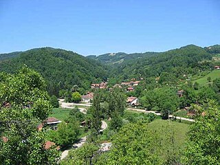
Kalenićki Prnjavor, or just Kalenić, is a village in Šumadija and Western Serbia (Šumadija), in the municipality of Rekovac. It lies at an altitude of 460 m. According to the 2002 census, the village had 154 residents. Kalenić is well known by Kalenić monastery.

Poběžovice u Přelouče is very small village in the Pardubice Region of the Czech Republic. It has 82 inhabitants (2005).

Musayelyan or Musayelian; formerly known as Bozyoxush is a village in the Shirak Province of Armenia. It was named after the Bolshevik military leader Sargis Musayelyan.

Çəmbərəxaç is a village in the Lachin Rayon of Azerbaijan.
Sarıyataq is a village in the Qubadli Rayon of Azerbaijan.
Agirdzha is a village in the Khizi Rayon of Azerbaijan.

Zagórze is a village in the administrative district of Gmina Niepołomice, within Wieliczka County, Lesser Poland Voivodeship, in southern Poland. It lies approximately 6 kilometres (4 mi) south-west of Niepołomice, 9 km (6 mi) east of Wieliczka, and 20 km (12 mi) south-east of the regional capital Kraków.

Łączna(listen) is a village in Skarżysko County, Świętokrzyskie Voivodeship, in south-central Poland. It is the seat of the gmina called Gmina Łączna. It lies approximately 17 kilometres (11 mi) south-west of Skarżysko-Kamienna and 18 km (11 mi) north-east of the regional capital Kielce.
Czyżówka is a village in the administrative district of Gmina Stara Błotnica, within Białobrzegi County, Masovian Voivodeship, in east-central Poland.
Boglewice is a village in the administrative district of Gmina Jasieniec, within Grójec County, Masovian Voivodeship, in east-central Poland. It lies approximately 11 kilometres (7 mi) south-east of Grójec and 46 km (29 mi) south of Warsaw.
Łychowska Wola is a village in the administrative district of Gmina Jasieniec, within Grójec County, Masovian Voivodeship, in east-central Poland.
Salomonka is a village in the administrative district of Gmina Nowe Miasto, within Płońsk County, Masovian Voivodeship, in east-central Poland.
Kamienica is a village in the administrative district of Gmina Woźniki, within Lubliniec County, Silesian Voivodeship, in southern Poland. It lies approximately 23 km (14 mi) east of Lubliniec and 43 km (27 mi) north of the regional capital Katowice.
Chlístov is a municipality and village in Benešov District in the Central Bohemian Region of the Czech Republic.

Srednje is a village in the municipality of Ilijaš, Bosnia and Herzegovina.
Voose is a village in Lääneranna Parish, Pärnu County, in western Estonia.
Torgu-Mõisaküla is a village in Saaremaa Parish, Saare County in western Estonia.
Beširevići is a village in the municipality of Srebrenica, Bosnia and Herzegovina.
Zelenyi Hai is a village in Zalishchyky Raion, Ternopil Oblast, Ukraine. It was named Zhezhava until 1950.
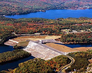
The Franklin Falls Dam is located on the Pemigewasset River in the city of Franklin, New Hampshire, in the United States. The dam was constructed between 1939 and 1943 by the Army Corps of Engineers and extends for 0.75 miles (1.21 km) across the river. During its construction, the neighboring residents of the town of Hill were forced to relocate to higher ground due to rising water levels created by the dam. The reservoir formed by the dam has a permanent pool covering 440 acres (180 ha), and the total flood storage capacity is 2,800 acres (1,100 ha). The total area of the project, including surrounding managed lands, is 3,683 acres (1,490 ha). The stretch of the Pemigewasset River potentially impounded by the dam extends 12.5 miles (20 km) north to Ayers Island Dam in the town of Bristol, and the watershed flowing to the dam extends north all the way into the White Mountains.
