Baklan is a town and a district of Denizli Province, in Turkey's Aegean Region. The town is at a distance of about an hour from the city of Denizli, neighboring the town of Çivril, and it is situated on the road to Ankara.

Ørestad station is a junction station served by both the Copenhagen Metro and regional trains in Copenhagen, Denmark. The penultimate stop of the M1 Line, it is located in zone 3 in the west-central section of the island of Amager.
Gaddamanugu Konduru is a part of Vijayawada and a village in NTR district of the Indian state of Andhra Pradesh.
Raków is a village in the administrative district of Gmina Długołęka, within Wrocław County, Lower Silesian Voivodeship, in south-western Poland.
Thatta is a small town and Union Council of Attock District in the Punjab province of Pakistan. The Khattar family of this village were of historical importance.
Trzebciny is a village in the administrative district of Gmina Cekcyn, within Tuchola County, Kuyavian-Pomeranian Voivodeship, in north-central Poland. It lies approximately 13 kilometres (8 mi) north-east of Cekcyn, 22 km (14 mi) east of Tuchola, and 59 km (37 mi) north of Bydgoszcz.
Izabelów is a village in the administrative district of Gmina Końskie, within Końskie County, Świętokrzyskie Voivodeship, in south-central Poland. It lies approximately 4 kilometres (2 mi) south of Końskie and 35 km (22 mi) north-west of the regional capital Kielce.
Czechów is a village in the administrative district of Gmina Kije, within Pińczów County, Świętokrzyskie Voivodeship, in south-central Poland. It lies approximately 4 kilometres (2 mi) south of Kije, 7 km (4 mi) north-east of Pińczów, and 34 km (21 mi) south of the regional capital Kielce.
Borek Czarniński is a village in the administrative district of Gmina Stanisławów, within Mińsk County, Masovian Voivodeship, in east-central Poland.

Kruszyna is a village in the administrative district of Gmina Jedlińsk within Radom County, Masovian Voivodeship, in east-central Poland.
Kozłowo is a village in the administrative district of Gmina Trzemeszno, within Gniezno County, Greater Poland Voivodeship, in west-central Poland. It lies approximately 5 kilometres (3 mi) west of Trzemeszno, 12 km (7 mi) north-east of Gniezno, and 60 km (37 mi) east of the regional capital Poznań.
Chojno-Młyn is a village in the administrative district of Gmina Wronki, within Szamotuły County, Greater Poland Voivodeship, in west-central Poland. It lies approximately 15 kilometres (9 mi) west of Wronki, 30 km (19 mi) west of Szamotuły, and 60 km (37 mi) north-west of the regional capital Poznań.
Wągniki is a settlement in the administrative district of Gmina Korsze, within Kętrzyn County, Warmian-Masurian Voivodeship, in northern Poland. It lies approximately 8 kilometres (5 mi) north of Korsze, 23 km (14 mi) north-west of Kętrzyn, and 67 km (42 mi) north-east of the regional capital Olsztyn.
Adel is an unincorporated community in northwestern Pushmataha County, Oklahoma, United States, 12 miles west of Clayton. Adel is located at 34°34′45″N95°35′40″W.
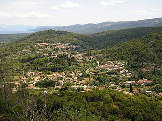
Dol is a village on the island of Hvar, Croatia. It has a population of 348. It is administratively located within the area of Stari Grad.
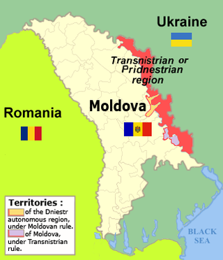
Șipca is a commune in the Grigoriopol sub-district of Transnistria, Moldova. It is composed of two villages, Șipca and Vesioloe. It is currently under the administration of the breakaway government of the Transnistrian Moldovan Republic.
Bandesar is a village in Ashrestaq Rural District, Yaneh Sar District, Behshahr County, Mazandaran Province, Iran. At the 2006 census, its population was 125, in 41 families.

Dương Quang is a commune (xã) and village in Bắc Kạn, Bắc Kạn Province, in Vietnam.
Kalugwis, or Karlukwees or Qalogwis, is the principal community of the Tlowitsis Nation of the Kwakwaka'wakw peoples of the Johnstone Strait region of the South Coast of British Columbia, Canada. It is located on the south shore of Turnour Island facing Beware Passage and is within Karlukwees Indian Reserve No. 1, a.k.a. Karlukwees 1, 10.8 ha.
Belty is a rural locality in Kurchaloyevsky District, Chechnya.
