River Road, Washington

Last updated

River Road, Washington
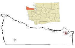
Clallam County Washington Incorporated and Unincorporated areas River Road Highlighted.svg
Location of River Road, Washington
Coordinates: 48°4′14″N123°7′37″W / 48.07056°N 123.12694°W / 48.07056; -123.12694 [1]
CountryUnited States
State Washington
County Clallam
Area
  Total0.33 sq mi (0.85 km2)
  Land0.33 sq mi (0.85 km2)
  Water0.0 sq mi (0.0 km2)
Elevation
315 ft (96 m)
Population
 (2010)
  Total454
  Density1,377/sq mi (531.7/km2)
Time zone UTC-8 (Pacific (PST))
  Summer (DST) UTC-7 (PDT)
ZIP code
98382 [2]
Area code 360
FIPS code 53-58777 [3]
GNIS feature ID1852957 [4]

River Road is a census-designated place (CDP) in Clallam County, Washington, United States. The population was 454 at the 2010 census. [5] It is a primarily residential area next to the city of Sequim.

Contents

Geography

River Road is located southwest of Sequim which borders the River Road community to the north, east, and south. U.S. Route 101, a two-lane freeway at this point, passes just north of the CDP, leading west into Carlsborg.

According to the United States Census Bureau, the River Road CDP has a total area of 0.33 square miles (0.85 km2), all of it land. [5] The CDP lost approximately half of its area to the city of Sequim between 2000 and 2010.

Demographics

Historical population
CensusPop.Note
2000 450
2010 4540.9%
2020 4959.0%

2000 census

As of the census [3] of 2000, there were 450 people, 178 households, and 134 families residing in the CDP. The population density was 724.0 people per square mile (279.5 people/km2). There were 192 housing units at an average density of 308.9 per square mile (119.3/km2). The racial makeup of the CDP was 90.22% White, 0.44% African American, 2.00% Native American, 3.78% Asian, 0.89% from other races, and 2.67% from two or more races. Hispanic or Latino of any race were 3.11% of the population.

There were 178 households, out of which 30.3% had children under the age of 18 living with them, 65.2% were married couples living together, 8.4% had a female householder with no husband present, and 24.7% were non-families. 19.7% of all households were made up of individuals, and 9.6% had someone living alone who was 65 years of age or older. The average household size was 2.53 and the average family size was 2.90.

In the CDP, the age distribution of the population shows 22.9% under the age of 18, 6.7% from 18 to 24, 21.6% from 25 to 44, 24.0% from 45 to 64, and 24.9% who were 65 years of age or older. The median age was 44 years. For every 100 females, there were 89.1 males. For every 100 females age 18 and over, there were 93.9 males.

The median income for a household in the CDP was $35,893, and the median income for a family was $46,875. Males had a median income of $36,071 versus $15,500 for females. The per capita income for the CDP was $18,142. None of the families and 3.4% of the population were living below the poverty line, including no under eighteens and 5.6% of those over 64.

2020 census

As of the 2020 census, there were 495 people, 228 housing units, and 280 families in the CDP. There were 400 White people, 0 African Americans, 17 Native Americans, 17 Asians, 14 people from some other race, and 47 people from two or more races. 24 people had Hispanic or Latino origin. [6]

The ancestry in River Road was 12.1% English, 6.8% Irish, 5.9% German, 2% Norwegian, and 2% Scottish. [6]

The median age was 53.9 years old. A total of 24.2% of the population was older than 65, with 12.2% between the ages of 65 and 74, 1.1% between the ages of 75 and 84, and 10.9% older than 85. A total of 16.2% of the population were foreign born. [6]

The median household income was $128,962. A total of 3.3% of the population were under the poverty line, with 6.1% of the population between the ages of 18 and 64 being in poverty. [6]
Related Research Articles

<span class="mw-page-title-main">Rock Creek, Alabama</span> CDP in Alabama, United States

Rock Creek is a census-designated place in Jefferson County, Alabama, United States. Its location is northwest of Hueytown. At the 2020 census, the population was 1,471. This area was damaged by an F5 tornado on April 8, 1998. An EF2 tornado struck northwest from here on January 23, 2012.

<span class="mw-page-title-main">Funny River, Alaska</span> Census-designated place in Alaska, United States

Funny River is a census-designated place (CDP) in Kenai Peninsula Borough, Alaska, United States. At the 2010 census the population was 877, up from 636 in 2000.

<span class="mw-page-title-main">Big River, California</span> Census-designated place in California, United States

Big River is a census-designated place (CDP) in San Bernardino County, California, United States. The population was 1,327 at the 2010 census, up from 1,266 at the 2000 census.

<span class="mw-page-title-main">Weatogue, Connecticut</span> Census-designated place in Connecticut, United States

Weatogue is a village and census-designated place in Simsbury, Hartford County, Connecticut. The population was 2,776 at the 2010 census.

<span class="mw-page-title-main">Essex Village, Connecticut</span> Census-designated place in Connecticut, United States

Essex Village is a village and census-designated place (CDP) in the town of Essex, Connecticut, in the United States. The population was 2,583 at the 2020 census, out of 6,733 in the entire town of Essex. The government offices of the town are located within the village.

<span class="mw-page-title-main">Sorrento, Florida</span> Census-designated place in Florida

Sorrento is an unincorporated community and census-designated place in Lake County, Florida, United States. The population was 861 at the 2010 census, up from 765 at the 2000 census. It is part of the Orlando–Kissimmee Metropolitan Statistical Area.

<span class="mw-page-title-main">Olga, Florida</span> Census-designated place in Florida, United States

Olga is an unincorporated community and census-designated place (CDP) in Lee County, Florida, United States. The population was 1,952 at the 2010 census, up from 1,398 at the 2000 census. It is part of the Cape Coral-Fort Myers, Florida Metropolitan Statistical Area.

<span class="mw-page-title-main">Mountain Park, Gwinnett County, Georgia</span> CDP in Georgia, United States

Mountain Park is an unincorporated, census-designated place in Gwinnett County, Georgia, United States. The population was 11,554 at the 2010 census. The older name for the area is Trickum, which is reflected in Five Forks-Trickum Road which bisects the community. The older community was centered on Five Forks and Rockbridge Roads.

<span class="mw-page-title-main">Southwood Acres, Connecticut</span> Census-designated place in Connecticut, United States

Southwood Acres is a suburban neighborhood within the town of Enfield in northern Hartford County, Connecticut, United States. The neighborhood is listed as a census-designated place (CDP) by the U.S. Census Bureau and had a population of 7,657 at the 2010 census.

<span class="mw-page-title-main">Garden City Park, New York</span> Hamlet and census-designated place in New York, United States

Garden City Park is a hamlet and census-designated place (CDP) located in the Town of North Hempstead in Nassau County, on Long Island, in New York, United States. The population was 7,806 at the 2010 census.

River Road is a census-designated place (CDP) in Beaufort County, North Carolina, United States. The population was 4,048 at the 2020 Census.

Schlusser pronounced (Skloosher) is a census-designated place (CDP) in North Middleton and Middlesex townships, Cumberland County, Pennsylvania, United States. The population was 5,265 at the 2010 census. It is part of the Harrisburg–Carlisle Metropolitan Statistical Area.

<span class="mw-page-title-main">East Berwick, Pennsylvania</span> Census-designated place in Pennsylvania, United States

East Berwick is a census-designated place (CDP) in Salem Township, Luzerne County, Pennsylvania, United States. The population was 2,007 at the 2010 census.

Seven Oaks is a census-designated place (CDP) in Lexington County, South Carolina, United States, 8 miles (13 km) northwest of downtown Columbia, the state capital. The population of the CDP was 15,144 at the 2010 census. It is part of the Columbia Metropolitan Statistical Area.

<span class="mw-page-title-main">Bell Hill, Washington</span> Census-designated place in Washington, United States

Bell Hill is an unincorporated community and census-designated place (CDP) in Clallam County, Washington, United States. The population was 837 at the 2010 census, up from 731 at the 2000 census. Located just south of the city of Sequim, Bell Hill has become a fast-growing destination for the very wealthy, with a high population of Californians who found success in high tech businesses. Although Sequim is not affluent, it is known for its low levels of rain, a quality that has made Bell Hill very attractive. Bell Hill gets somewhat more precipitation than Sequim but is drier than most western Washington areas.

<span class="mw-page-title-main">Blyn, Washington</span> Census-designated place in Washington, United States

Blyn is a census-designated place (CDP) in Clallam County, Washington, United States. The population was 101 at the 2010 census, down from 162 at the 2000 census. It is located near the city of Sequim on the shores of Sequim Bay. The area includes the Jamestown S'Klallam Indian Reservation, established in 1874 by the Jamestown S'Klallam Tribe, who named their community Jamestown after their leader; Lord James Balch.

<span class="mw-page-title-main">Port Angeles East, Washington</span> Census-designated place in Washington, United States

Port Angeles East is a census-designated place (CDP) in Clallam County, Washington, United States. The population was 3,036 at the 2010 census. This unincorporated urban growth area bordering the city of Port Angeles is known by locals as the Gales Addition.

Moose Wilson Road is a census-designated place (CDP) in Teton County, Wyoming, United States. The population was 1,821 at the 2010 census. It is part of the Jackson, WY–ID Micropolitan Statistical Area.

Germantown is a census-designated place (CDP) in the town of Germantown in Columbia County, New York, United States, on the east side of the Hudson River. The population of the CDP was 845 at the 2010 census, out of a total town population of 1,954.

Norfolk is a hamlet in St. Lawrence County, New York, United States. The population was 1,327 at the 2010 census.

References

  1. "US Gazetteer files: 2010, 2000, and 1990". United States Census Bureau. February 12, 2011. Retrieved April 23, 2011.
  2. "River Road WA ZIP Code". zipdatamaps.com. 2023. Retrieved June 16, 2023.
  3. 1 2 "U.S. Census website". United States Census Bureau . Retrieved January 31, 2008.
  4. "US Board on Geographic Names". United States Geological Survey. October 25, 2007. Retrieved January 31, 2008.
  5. 1 2 "Geographic Identifiers: 2010 Demographic Profile Data (G001): River Road CDP, Washington". U.S. Census Bureau, American Factfinder. Retrieved August 27, 2015.[ dead link ]
  6. 1 2 3 4 "Explore Census Data". data.census.gov. Retrieved May 30, 2023.