Rollag Municipality Rollag kommune | |
---|---|
Coordinates: 60°1′2″N9°14′2″E / 60.01722°N 9.23389°E | |
Country | Norway |
County | Buskerud |
District | Numedal |
Administrative centre | Rollag |
Government | |
• Mayor (2003) | Steinar Berthelsen (Ap) |
Area | |
• Total | 449 km2 (173 sq mi) |
• Land | 430 km2 (170 sq mi) |
• Rank | #225 in Norway |
Population (2021) | |
• Total | 1,369 |
• Rank | #369 in Norway |
• Density | 3/km2 (8/sq mi) |
• Change (10 years) | −0.9% |
Demonym | Rølling [1] |
Official language | |
• Norwegian form | Neutral |
Time zone | UTC+01:00 (CET) |
• Summer (DST) | UTC+02:00 (CEST) |
ISO 3166 code | NO-3336 [3] |
Website | Official website |
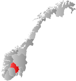
Rollag is a municipality in Buskerud county, Norway. It is part of the traditional region of Numedal. The administrative centre of the municipality is the village of Rollag, although the most populated area in the municipality is Veggli. Rollag is bordered in the north by Nore og Uvdal, in the east by Sigdal, in the south by Flesberg, and in the west by Tinn in Telemark. [4]
The municipality (originally the parish) is named after the old Rollag farm (Old Norse: Roll(u)lag), since the first church was built here. The first element is probably (the genitive case of) a river name Rolla (now called the Troelva river) and the last element is lag which means "fishing place". [5]
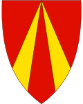
The municipality of Rollag was established on 1 January 1838 (see formannskapsdistrikt). Nore og Uvdal was separated from Rollag in 1858. The coat-of-arms is from modern times. They were granted in 1993. The arms show two gold-colored lines on a red background. The lines represent an old warning cairn made of timber.
Ancestry | Number |
---|---|
Somalia | 31 |
Eritrea | 17 |
Lithuania | 15 |
The municipality lies in the heart of the Numedal traditional region and valley, the westernmost valley in southeastern Norway. The river Numedalslågen flows through Rollag and into the Ytre Oslofjord at Larvik. In the northwest of the Rollag lie the Vegglifjell mountains, which are an entryway into the Hardangervidda. The municipality's highest point is Storegrønut at 1,289 metres (4,229 ft) located in the Vegglifjell mountains. [7] [8]
Rollag stave church (Rollag stavkirke) was built around 1150–1200. It is located a few kilometres north of the centre of Rollag. It was extended and windows were added in 1652. A new Apse was added in 1666. The transept was constructed in 1697–1698. A gallery was added in 1702. The sacristy was built in 1739. A Baroque pulpit was added in 1763. [9] [10]
Buskerud is a county and a current electoral district in Norway, bordering Akershus, Oslo, Oppland, Sogn og Fjordane, Hordaland, Telemark and Vestfold. The region extends from the Oslofjord and Drammensfjorden in the southeast to Hardangervidda mountain range in the northwest. The county administration was in modern times located in Drammen. Buskerud was merged with Akershus and Østfold into the newly created Viken County on 1 January 2020. On the 23 February 2022 Viken County Council voted in a 49 against 38 decision to submit an application to the Norwegian government for a county demerger. Due to this, Buskerud will be re-established in 2024.
Nore og Uvdal is a municipality in Buskerud county, Norway. It is part of the traditional region of Numedal. The administrative centre of the municipality is the village of Rødberg.
is a municipality in Buskerud county, Norway. It is part of the traditional region of Hallingdal. The administrative center of the municipality is the village of Gol which is also the population center. Gol was established as a municipality on 1 January 1838. The area of Hemsedal was separated from Gol in 1897 to become a separate municipality. The municipality of Gol is bordered to the north by the municipality of Nord-Aurdal, to the east by Sør-Aurdal, to the south by Nes, and to the west by Ål and Hemsedal.
Hol is a municipality in Buskerud county, Norway.
Sigdal is a municipality in Buskerud county, Norway. The administrative centre of the municipality is the village of Prestfoss.
Flesberg is a municipality in Buskerud county, Norway. It is part of the traditional region of Numedal. The administrative centre of the municipality is the village of Lampeland.
Numedal is a valley and a traditional district in Eastern Norway located within the county of Buskerud. It traditionally includes the municipalities Flesberg, Nore og Uvdal and Rollag. Administratively, it now also includes Kongsberg.
Numedalslågen is a river in Norway. It is considered to be the second longest river in Southern Norway. It is located in the Numedal valley which runs through the counties of Vestfold, Buskerud and Vestland. At 356 kilometres (221 mi) long, it is of the longest rivers in Norway.
Uvdal Stave Church is situated at Uvdal in the valley Numedal in Nore og Uvdal in Buskerud, Norway. The stave church was originally constructed just after the year 1168, which is known through dendrochronological dating of the ore-pine used in the construction. The logs were not completely dry when the construction took place.
Nore Stave Church is a stave church located at Nore in Nore og Uvdal kommune in Viken county, Norway.
The Numedal Line is a 92.8-kilometer (57.7 mi) long railway line that runs up the Numedal valley between Kongsberg and Rødberg in Viken county, Norway. Built and operated by the Norwegian State Railways, the non-electrified, standard gauge line passes through the municipalities of Kongsberg, Flesberg, Rollag and Nore og Uvdal. It is now owned by the Norwegian National Rail Administration.
Rødberg is the administrative centre of Nore og Uvdal municipality in Buskerud, Norway.
Veggli is a village in the municipality of Rollag, in the county of Buskerud, Norway.
Nore is a village in the municipality of Nore og Uvdal in the county of Buskerud, Norway. It is located in the traditional region of Numedal.
Uvdal is a village and former municipality in Buskerud county, Norway. It is situated in the traditional region of Numedal and is the location of the Uvdal Stave Church.
Bjornesfjorden is a lake in the municipality of Nore og Uvdal in Viken county, Norway. It lies at 1,223 meters above sea level. It is drained by the Numedalslågen. Bjornesfjorden is situated in the Hardangervidda plateau and lies within the Hardangervidda National Park.
Norefjorden is a lake in the municipality of Nore og Uvdal in Viken county, Norway. Norefjorden is a long, narrow mountain lake which is known for its fishing. Numedalslågen flows into the far north and exits travelling southward to Kravikfjorden. Norefjord bridge goes across the lake between Norefjord and Gvåle. The surrounding terrain is steep and forested.
Øvre Hein is a lake in the municipalities of Nore og Uvdal and Hol in Viken county, Norway. The lake is ;located in the eastern Hardangervidda and lies partly in the Hardangervidda National Park.
Vegglifjell is a mountain range located along the border of Buskerud and Telemark counties in southern Norway. It runs through the municipalities of Tinn, Rollag, and Nore og Uvdal. The highest point is the 1,380-metre (4,530 ft) tall Skirveggen mountain. The mountain range is surrounded by the Numedalen valley to the east side, the Uvdalen valley to the north, and the Tessungdalen valley on the west side.
Buskerud District Court is a district court located Buskerud, Norway. This court is based at four different courthouses which are located in Drammen, Hokksund, Kongsberg, and Nesbyen. The court serves the western part of Buskerud which includes cases from 16 municipalities. The court in Drammen accepts cases from the municipalities of Drammen and Lier. The court in Hokksund accepts cases from the municipalities of Øvre Eiker, Modum, Sigdal, and Krødsherad. The court in Kongsberg accepts cases from the municipalities of Flesberg, Kongsberg, Nore og Uvdal, and Rollag. The court in Nesbyen accepts cases from the municipalities of Flå, Hemsedal, Hol, Gol, Nesbyen, and Ål. The court is subordinate to the Borgarting Court of Appeal.