
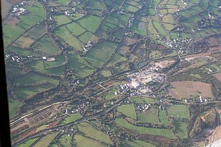
St Columb Major is a town and civil parish in Cornwall, England, United Kingdom. Often referred to locally as St Columb, it is approximately seven miles (11 km) southwest of Wadebridge and six miles (10 km) east of Newquay The designation Major distinguishes it from the nearby settlement and parish of St Columb Minor on the coast. An electoral ward simply named St Columb exists with a population at the 2011 census of 5,050.

The culture of Cornwall forms part of the culture of the United Kingdom, but has distinct customs, traditions and peculiarities. Cornwall has many strong local traditions. After many years of decline, Cornish culture has undergone a strong revival, and many groups exist to promote Cornwall's culture and language today.

Advent is a civil parish on the north-western edge of Bodmin Moor in north Cornwall, England. The English name St Adwenna derives from the Cornish Adhwynn and lies in the Registration District of Camelford.

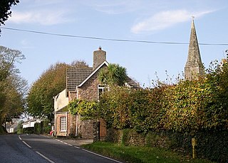
St Mawgan or St Mawgan in Pydar is a village and civil parish in Cornwall, England, United Kingdom. The population of this parish at the 2011 census was 1,307. The village is situated four miles northeast of Newquay, and the parish also includes the hamlet of Mawgan Porth. The nearby Royal Air Force station, RAF St. Mawgan, takes its name from the village and is next to Newquay Cornwall Airport. The River Menalhyl runs through St Mawgan village and the valley is known as The Vale of Lanherne. It was the subject of a poem by poet Henry Sewell Stokes.

Delabole is a large village in north Cornwall, England, UK. It is situated approximately two miles (3 km) west of Camelford. It is in the civil parish of St Teath

Cubert is a village in Cornwall, United Kingdom. It is three miles (5 km) south-southwest of Newquay and is in the civil parish of Cubert.
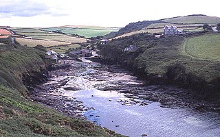
Port Quin grid reference SW971805 is a small cove and hamlet between Port Isaac and Polzeath in north Cornwall, England, UK.
Branwalator or Breward, also referred to as Branwalader, was a British saint whose relics lay at Milton Abbas in Dorset and Branscombe in Devon. Believed to come from Brittany, he also gives his name to the parish of Saint Brélade, Jersey. "Brelade" is a corruption of "Branwalader". He is also known as Breward or Branuvelladurus or Brélade and Broladre in French.

St Endellion is a civil parish and hamlet in north Cornwall, England, United Kingdom. The hamlet and parish church are situated four miles (6.5 km) north of Wadebridge.

Boswednack is a hamlet in the parish of Zennor near the north coast of the Penwith peninsula in Cornwall, England, United Kingdom. It is located along the B3306 road southwest of Zennor.

Withiel is a civil parish and village in mid Cornwall, England, United Kingdom. The parish of Withiel is between the parishes of St Breock, Lanivet, Roche and St Wenn. The name Withiel comes from the Cornish word Gwydhyel, meaning "wooded place". The parish contains the hamlets of Withielgoose, Retire and Tregawne; the parish had a total population of about 300 in 1824.

Launcells is a hamlet and civil parish in north-east Cornwall, England, United Kingdom. It is located 3 miles (4.8 km) east of Bude.
The Red River is a small river in north-west Cornwall, United Kingdom which issues into St Ives Bay at Godrevy on Cornwall's Atlantic coast. The Red River is about 8 miles (13 km) long and was given its name from the mineral deposits associated with tin mining which formerly coloured its water red. The river's gradient is relatively steep; the stream falls 170 metres (560 ft) from source to sea.

Tresmeer is a hamlet and a civil parish in northeast Cornwall, England, United Kingdom. The hamlet is situated approximately seven miles (11 km) northwest of Launceston.
Landulph is a hamlet and a rural civil parish in south-east Cornwall, England, United Kingdom. It is about 3 miles (5 km) north of Saltash in the St Germans Registration District.
Sheviock is a coastal civil parish and a hamlet in south-east Cornwall, England, United Kingdom. The parish is two miles (3 km) south of St Germans and three miles (5 km) south-west of Saltash.
Bissoe is a hamlet in west Cornwall, England, United Kingdom. It is situated five miles (8 km) east of Redruth in a former tin mining area. It is in the civil parish of Kea
Trewarmett is a small hamlet in Cornwall, England, United Kingdom. It lies within the civil parish of Tintagel, 3 miles (5 km) north-west of Camelford. To the west of Trewarmett is Trebarwith Nature Reserve.

Carnebone is a small hamlet and farm in the parish of Wendron in Cornwall, England. It lies to the east of Wendron, to the northeast of Trevenen, just to the west of Seworgan, along the A394 road, 3.8 miles (6.1 km) northeast of Helston.
