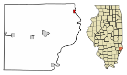
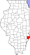
Russellville, Illinois | |
---|---|
Coordinates: 38°49′08″N87°31′48″W / 38.81889°N 87.53000°W [1] | |
Country | United States |
State | Illinois |
County | Lawrence |
Township | Russell |
Area | |
• Total | 0.41 sq mi (1.06 km2) |
• Land | 0.40 sq mi (1.03 km2) |
• Water | 0.01 sq mi (0.02 km2) |
Elevation | 427 ft (130 m) |
Population (2020) | |
• Total | 98 |
• Density | 245.00/sq mi (94.71/km2) |
Time zone | UTC-6 (CST) |
• Summer (DST) | UTC-5 (CDT) |
ZIP code | 62439 |
Area code | 618 |
FIPS code | 17-66404 |
GNIS feature ID | 2399148 [1] |
Wikimedia Commons | Russellville, Illinois |
Russellville is a village in Lawrence County, Illinois, United States. The population was 94 at the 2010 census. [3]
Russellville is rooted in a fort built by Samuel and Jonathan Allison near the site of an abandoned Indian village known as "Little Village" in the early 1800s. [4] A town site was platted in 1835, and named for the Russell brothers, August, Andrew, and Clement, who provided lumber for the settlement's first buildings. Russellville incorporated in 1875. [5]
Russellville is located in northeastern Lawrence County on the west bank of the Wabash River, which forms the Illinois–Indiana border. Illinois Route 33 passes through the village center, leading north 14 miles (23 km) to Palestine and south 10 miles (16 km) to Westport, across the river from Vincennes, Indiana.
According to the 2010 census, Russellville has a total area of 0.47 square miles (1.22 km2), all land. [6]
Census | Pop. | Note | %± |
---|---|---|---|
1870 | 311 | — | |
1880 | 265 | −14.8% | |
1890 | 284 | 7.2% | |
1900 | 253 | −10.9% | |
1910 | 257 | 1.6% | |
1920 | 200 | −22.2% | |
1930 | 205 | 2.5% | |
1940 | 224 | 9.3% | |
1950 | 207 | −7.6% | |
1960 | 197 | −4.8% | |
1970 | 174 | −11.7% | |
1980 | 171 | −1.7% | |
1990 | 133 | −22.2% | |
2000 | 119 | −10.5% | |
2010 | 94 | −21.0% | |
2020 | 98 | 4.3% | |
U.S. Decennial Census [7] |
As of the census [8] of 2000, there were 119 people, 52 households, and 27 families residing in the village. The population density was 259.5 inhabitants per square mile (100.2/km2). There were 68 housing units at an average density of 148.3 per square mile (57.3/km2). The racial makeup of the village was 94.96% White, 0.84% from other races, and 4.20% from two or more races. Hispanic or Latino of any race were 10.08% of the population.
There were 52 households, out of which 23.1% had children under the age of 18 living with them, 44.2% were married couples living together, 7.7% had a female householder with no husband present, and 46.2% were non-families. 44.2% of all households were made up of individuals, and 13.5% had someone living alone who was 65 years of age or older. The average household size was 2.29 and the average family size was 3.21.
In the village, the population was spread out, with 29.4% under the age of 18, 7.6% from 18 to 24, 25.2% from 25 to 44, 22.7% from 45 to 64, and 15.1% who were 65 years of age or older. The median age was 39 years. For every 100 females, there were 105.2 males. For every 100 females age 18 and over, there were 104.9 males.
The median income for a household in the village was $23,750, and the median income for a family was $31,667. Males had a median income of $30,417 versus $16,250 for females. The per capita income for the village was $11,843. There were 19.2% of families and 42.5% of the population living below the poverty line, including 53.1% of under eighteens and 55.0% of those over 64.
Franklin County is a county located in the U.S. state of Alabama. As of the 2020 census, the population was 32,113. Its county seat is Russellville. Its name is in honor of Benjamin Franklin, famous statesman, scientist, and printer. It is a dry county, although the city of Russellville is wet.
Lawrence County is the easternmost county in the U.S. state of Illinois. At the 2020 census, the population was 15,280. Its county seat is Lawrenceville.
Stoy is a village in Crawford County, Illinois, United States. The population was 108 at the 2020 census.
Banner is a village in Fulton County, Illinois, United States. The population was 189 at the 2010 census, up from 149 at the 2000 census.
Bryant is a village in Fulton County, Illinois, United States. The population was 220 at the 2010 census, down from 255 at the 2000 census.
Fairview is a village in Fulton County, Illinois, United States. The population was 426 at the 2020 census.
Table Grove is a village in Fulton County, Illinois, United States. Its population was 416 as of the 2010 census.
Basco is a village in Bear Creek Township, Hancock County, Illinois, United States. The population was 98 at the 2010 census.
Cissna Park is a village in Pigeon Grove Township, Iroquois County, Illinois, United States. The population was 846 at the 2010 census.
Martinton is a village in Martinton Township, Iroquois County, Illinois, United States. The population was 381 at the 2010 census.
Campbell Hill is a village in Jackson County, Illinois, United States. The population was 309 at the 2020 census.
St. Augustine or Saint Augustine is a village in Knox County, Illinois, United States. The population was 120 at the 2010 census, down from 152 at the 2000 census. It is part of the Galesburg Micropolitan Statistical Area.
Eagarville is a village in Macoupin County, Illinois, United States. The population was 114 at the 2020 census.
Perry is a village in Pike County, Illinois, United States. The population was 397 at the 2010 census.
Ruma is a village in Randolph County, Illinois, United States. The population was 317 at the 2010 census.
Oconee is a village in Shelby County, Illinois, United States. The population was 180 at the 2010 census.
Russellville is a town in Russell Township, Putnam County, in the U.S. state of Indiana. The population was 358 at the 2010 census.
Russellville is a city in Cole County, Missouri, United States. The population was 778 at the 2020 census. It is part of the Jefferson City, Missouri Metropolitan Statistical Area.
Russellville is a village in Jefferson Township, Brown County, Ohio, United States. The population was 542 at the 2020 census.
Poplar Grove Township is one of nine townships in Boone County, Illinois, USA. As of the 2020 census, its population was 5,131 and it contained 1,834 housing units. Poplar Grove Township was formed from parts of Caledonia Township and Boone Township after 1921.