Ryton, Shropshire

Last updated

Ryton
St Andrew's Church, Ryton - geograph.org.uk - 1081296.jpg
St Andrew's Church
Shropshire UK location map.svg
Red pog.svg
Ryton
Location within Shropshire
Population174 (2011) [1]
OS grid reference SJ760025
Civil parish
  • Ryton
Unitary authority
Ceremonial county
Region
Country England
Sovereign state United Kingdom
Post town Shifnal
Postcode district TF11
Dialling code 01952
Police West Mercia
Fire Shropshire
Ambulance West Midlands
UK Parliament
List of places
UK
England
Shropshire
52°37′12″N2°21′18″W / 52.620°N 2.355°W / 52.620; -2.355 Coordinates: 52°37′12″N2°21′18″W / 52.620°N 2.355°W / 52.620; -2.355

Ryton is a village and civil parish in Shropshire, England, in the district of Bridgnorth. It lies about one mile north north west of Beckbury. The civil parish originates during Norman times, and appears as "Ruitone" in the Domesday book of 1086. [2] Ryton was part of the Saxon parish of Shifnal, but became separate at some point during the 12th century because there is mention of a priest at Ryton named Bernard in 1186. [2]

Contents

In 1643 John Craven was created Baron Craven of Ryton, named after this village, but the title died out with his death in 1648. [3]

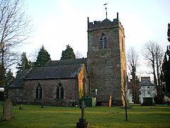
Ryton is home to St Andrew's church, in which records first appear of its existence in 1710 [2]

Ryton Hall, built by Romolo Piazzani, [4] was for a time an independent boarding school for girls, from 1954 to 1983 an ESN school run by Wolverhampton Borough Council, and is now apartments with houses built in the garden. [4] [5]

(Not to be confused with the small village of Great Ryton, which also is in Shropshire, in the parish of Condover, south of Shrewsbury.)

Population

In 1801, the recorded population of Ryton was 160, with 81 males and 79 females. [6] Between 1801 and 1861 the population rose to 264, with 163 of these being male. [6] However, there was no steady, consistent rise to the population, instead there were a number of periods where it actually dropped, for example between 1811 and 1821 the population dropped from 170 to 131. [6] Another example is between 1881 and 1901, where the population dropped from 212 to 121. [7] In 2001, the total population stood at 156, with 82 being male. [8] Being a location with such a small population, it is perhaps no surprise that there are very large changes in the percentage of population, as it would not have taken a lot of people to make a large change. Interesting to note that the time in which Ryton's population increases the most, is at a time when England and Wales' decline, which also falls at the time of World War I. [9] The population density of Ryton is a much lower population density compared to the average of England and Wales, which is expected due to its rural location. England and Wales show a steady increase in population density, whereas Ryton hardly changed at all between 1880 and 1960. [10]

Population Graph of Ryton [11]

Industry

Historically, the majority of the working population of Ryton have worked in agriculture, unsurprising considering the rural location. In 1831, 30 out of 53 economically active males aged over 20 worked as agricultural labourers. [12] This therefore gives us an idea of the social status of the majority of people at this time, as the vast majority of people were either a labourer or a servant. [13] In 1881, with economically active males again agriculture is the most common sector. With females however, the most common is of an unknown occupation, followed closely by domestic service or offices. [14] In more recent times however, employment is more evenly split, with 30 working in the Extractive and Manufacturing industries, and 43 working in the service industries. [15]

Pie Chart of Occupational structure of men in Ryton, 1831 [16]

Chart of Occupational structure of men and women in Ryton, 1881 [17]

Housing

Between 1831 and 1961 there was only an increase of 14 households in Ryton, signalling that there was not a great deal of change or development in the area. [18] The biggest increase seen was between 1931–1951, with 17 new houses built, possibly due to post war development. [19] Another point which re-emphasises the lack of development in Ryton, is that between 1831 and 1961 there were no houses under construction. [20] During the same time, the vast majority of houses were occupied, with vacant houses peaking at only 7 in 1901, suggesting a very stable community. [20] In 2001, the total dwelling count stood at 57, with no vacant household spaces and an average household size of 2.84 people. [21]

St. Andrew's Church

Although there is evidence of medieval stonework within the church, the first record dates back to 1710, in which a tablet in the tower wall commemorates the church wardens who possibly were responsible for the building of the tower. [4]

Originally there were three bells, but then a further two were added in 1887 to mark Queen Victoria's 50th Jubilee, and a sixth bell was added in 1993. [4] The font is unusual, in that it is recessed into the tower arch and the style of its carved decorations suggests that it is a 14th-century creation. [4] There is one war memorial, a plaque to Major Wilfred Bernard Foster who died of wounds in Burma in 1945. [22]

The Reverend Robert William Eyton (1815–1881), author of The Antiquities of Shropshire, was Rector at Ryton for 22 years, during which period he researched this work, published in 1860. [23]

Colonel William Kenyon-Slaney (1847–1908), sportsman and politician, whose family home, Hatton Grange, is in the parish, is buried in the churchyard. [24]

The Italian Romolo Piazzani is also buried here. He is credited with building Ryton Hall, and as well as being a landscape gardener, he has a portrait in a private collection in Montrose Scotland

See also

Related Research Articles

<span class="mw-page-title-main">Westbury, Shropshire</span> Human settlement in England

Westbury is a village and parish in Shropshire, England. It includes the settlements of Caus Forest, Lake, Marche, Newtown, Stoney Stretton, Vennington, Wallop, Westbury, Whitton, Winsley and Yockleton. It lies 8 miles (13 km) west of the town of Shrewsbury, very close to the Wales-England border. It is located at 135 m altitude. It had a population of 1,352 according to the 2011 census. In 2005, Westbury parish expanded with the annexation of half of the former Wollaston parish.

<span class="mw-page-title-main">Acton Turville</span> Human settlement in England

Acton Turville is a parish in the Cotswold Edge ward within South Gloucestershire, England. It lies 17 miles (27 km) east-northeast of Bristol and 93 miles (150 km) due west of London, with the M4 south of the parish. Acton Turville consists of a cluster of households across 1,009 acres, with a total population of 370 people. Acton Turville is also listed as "Achetone" in the Domesday Book.

<span class="mw-page-title-main">Kilby</span> Human settlement in England

Kilby is a village and civil parish in the Blaby district of Leicestershire, England. Kilby is the easternmost village in the district, and is 6.1 miles (9.8 km) south east of Leicester. Kilby civil parish includes the former parish of Foston and it's deserted medieval village. Nearby places are Countesthorpe 2.21 miles (3.56 km), Fleckney 2.12 miles (3.41 km), Arnesby 1.96 miles (3.15 km), Wistow 1.4 miles (2.3 km) and Kilby Bridge 1.18 miles (1.90 km).

<span class="mw-page-title-main">Astley Abbotts</span> Human settlement in England

Astley Abbotts is a village and civil parish in Shropshire, England, located immediately north of Bridgnorth, and straddling the B4373 Bridgnorth to Broseley road. According to the 2001 census the parish had a population of 396.

<span class="mw-page-title-main">Beckbury</span> Village and civil parish in Shropshire, England

Beckbury is a village and civil parish in Shropshire, England. Beckbury had a population of 327 according to the 2001 census, increasing to 340 at the 2011 Census, The village is 8 miles (13 km) south-east of Telford and is close to the Staffordshire border. The small rural parish of Beckbury lies on the Shropshire–Staffordshire border 3.7 miles (6 km) south of Shifnal. It has a pub – the Smokey Cow, a Church of England school, a village hall, and a parish church dedicated to St Milburga.

<span class="mw-page-title-main">Albrighton, Shrewsbury</span> Human settlement in England

Albrighton is a small village in the North Shropshire district of Shropshire, England. It is situated on the A528 Shrewsbury-Ellesmere road and is roughly 4.0 miles (6.4 km) north of Shrewsbury. After a history of being its own parish, it currently lies in the parish of Pimhill. According to the United Kingdom Census 2001, the parish population of Pimhill was 2008, with the number of these habiting in Albrighton being 273.

<span class="mw-page-title-main">Tingrith</span> Human settlement in England

Tingrith is a small village and civil parish in Bedfordshire, England. It is located adjacent to the M1 motorway near the large village of Toddington. The nearest major town is Luton, located about 10 miles (16 km) to the southeast. The parish church of St Nicholas dates back to the 13th century and has Tingrith's only cemetery. The church can seat up to 200 people.

<span class="mw-page-title-main">Pitchford</span> Human settlement in England

Pitchford is a small village in the English county of Shropshire. It is located between Cantlop and Acton Burnell and stands on an affluent of the River Severn. Pitchford takes its name from a bituminous spring/pitch in the village, located near The Row Brook. It is also home to one of the most notable Elizabethan houses in Britain- Pitchford Hall. The Church of St Michael and All Angels stands near to the house which contains a carved oak 13th century effigy of Sir John de Pitchford. It is also the name for the civil parish.

<span class="mw-page-title-main">Stirchley, Shropshire</span> Human settlement in England

Stirchley is a large village and suburb of the new town of Telford, in the borough of Telford and Wrekin and ceremonial county of Shropshire, England. Stirchley lies just south-east of the town centre, and shares a parish council with neighbouring Brookside, which together have a population of 10,533 according to the 2001 census data It is close to Dawley and Malinslee and located next to the southern side of Telford town park. Although formerly a farming parish, it was incorporated into the Telford New Town in the 1970s. There are some important heritage sites in the parish, notably St James Church, Stirchley Hall, Stirchley Grange and the Stirchley Chimney, now a local landmark. A number of Stirchley's heritage sites are waypoints on the South Telford Heritage Trail. The former school was removed brick-by-brick and rebuilt at the nearby Blists Hill Victorian Town museum in 1993.

<span class="mw-page-title-main">Worthen</span> Village in Shropshire, England

Worthen is a village in Shropshire, England approximately 13 miles west of Shrewsbury. The village forms part of the Worthen with Shelve civil parish, which includes the hamlet of Little Worthen immediately to the north-east and the villages of Brockton and Pennerley, in addition to several smaller settlements. It sits in the Rea Brook valley. To the south are the Stiperstones and the Bromlow Callow, known for the small clump of trees on top. To the north is Long Mountain.

<span class="mw-page-title-main">Copgrove</span> Village and civil parish in North Yorkshire, England

Copgrove is a village and civil parish in the Harrogate district of North Yorkshire, England, five miles (8 km) south-west of Boroughbridge and the A1(M) motorway. The village is close to Rober Beck, which has been influenced by glaciers and overflowing channels.

<span class="mw-page-title-main">Kinlet</span> Human settlement in England

Kinlet is a small village and civil parish in the south-east of the county of Shropshire, England. The parish is on the northern edge of the Wyre Forest and is in the Bridgnorth District of Shropshire. The parish incorporates the hamlets of Kinlet Village, Button Bridge and Button Oak. Kinlet is located 18 miles (29 km) south of Telford, the main town in Shropshire and 23 miles (37 km) west of Birmingham.

<span class="mw-page-title-main">Rushbury</span> Human settlement in England

Rushbury is a village and civil parish in Shropshire, roughly five miles from Church Stretton and eight miles from Much Wenlock.

<span class="mw-page-title-main">Langford, Nottinghamshire</span> Human settlement in England

Langford is a village and civil parish in Nottinghamshire, England. It is located four miles north-east of Newark-on-Trent and two miles East from The River Trent. Population details are included in the civil parish of Holme. It is based on A1133 which comes off of the A46. Although Langford is currently located two miles from The River Trent it has not always been this way. In "1575 there was a cataclysmic flood" which altered the course of the Trent which meant Langford and Holme were now on the same side of the river. Before this change in the rivers course the Trent used to flow next to St Bartholomew's church and Holme was on the opposite side of the bank.

<span class="mw-page-title-main">Chetton</span> Human settlement in England

Chetton is a small village and civil parish in Shropshire, England. According to the 2011 census the parish had a population of 349. It is about 20 miles (32 km) to the West of Wolverhampton in West Midlands and South of Telford. The parish church has a fine set of church bells

<span class="mw-page-title-main">Ditton Priors</span> Human settlement in England

Ditton Priors is a village and civil parish in south Shropshire, England. Historically, it was also known as Priors Ditton.

<span class="mw-page-title-main">Ousden</span> Human settlement in England

Ousden is a village and civil parish in the West Suffolk district of Suffolk in eastern England. It is located around six miles west of Bury St Edmunds and 72 miles north of London, and as of 2011, its population is 266. The village has an Anglican church of St Peter's and a chapel in the cemetery dedicated to St Barnabas.

<span class="mw-page-title-main">Neenton</span> Human settlement in England

Neenton is a civil parish and small village in south east Shropshire, England, which is situated on the B4364 southwest of the market town of Bridgnorth. The Rea Brook/River Rea, which was historically known as the River Neen, flows by the village. There is a church on the corner of the B4364 passing through Neenton called the All Saints Church, also there is a public house open, called the Pheasant Inn.

<span class="mw-page-title-main">Great Bolas</span> Human settlement in England

Great Bolas, or Bolas Magna, is a small village in rural Shropshire, England. It is situated north-west of the town of Newport, and about eight miles north of Telford. It is part of the civil parish of Waters Upton. It is situated at the confluence of the Tern and the small River Meese. There is a hamlet called Little Bolas a short distance to the west. Another hamlet called Meeson, south of the River Meese, was formerly a separate township of Great Bolas parish.

<span class="mw-page-title-main">Great Henny</span> Human settlement in England

Great Henny is a village and civil parish near Sudbury, in the Braintree district, in the county of Essex, England. Nearby settlements include the villages of Little Henny and Twinstead. The hamlet of Henny Street, within the parish, is on the River Stour which forms the parish's eastern border.

References

  1. "Civil Parish population 2011" . Retrieved 30 November 2015.
  2. 1 2 3 Archived 15 May 2008 at the Wayback Machine Beckbury Group Ministry, St Andrew, Ryton, last retrieved 5/4/2012
  3. [ permanent dead link ] A vision of Britain Through Time, Historical Writing, Ryton, last retrieved 5/4/2012
  4. 1 2 3 4 5 Archived 15 May 2008 at the Wayback Machine Beckbury Group Ministry, St Andrew, Ryton, last retrieved 18 April 2012
  5. Ryton Hall Special School, Black Country History
  6. 1 2 3 1851 Census of Great Britain, Population tables 2, Population abstract, as available online at A Vision of Britain through Time, last retrieved 10/4/2012
  7. 1881–1901 Census' of England and Wales, as available online at A Vision of Britain through Time, last retrieved 10/4/2012
  8. 2001 Census, key statistics, neighbourhood statistics, last retrieved 10/4/2012
  9. Rate of population change as available online at A Vision of Britain through Time, last retrieved 10/4/2012
  10. Population density as available online at A Vision of Britain through Time, last retrieved 10/4/2012
  11. Population Graph of Ryton, as available online at A Vision of Britain through Time, last retrieved 25 April 2012
  12. 1831 Census of Great Britain, as available online at A Vision of Britain through Time, last retrieved 16 April 2012
  13. 1831 Census of Great Britain, as available online at A Vision of Britain through Time, last retrieved 16 April 2012
  14. 1881 Census of England and Wales, as available online at A Vision of Britain through Time, last retrieved 16 April 2012
  15. 2001 Census, Education, Skills and Taining, Neighbourhood Statistics, last retrieved 16 April 2012
  16. Occupational structure of men in Ryton, as available online at A Vision of Britain through Time, last retrieved 25 April 2012
  17. Occupational structure of men and women in Ryton, as available online at A Vision of Britain through Time, last retrieved 25 April 2012
  18. 1831–1961 Census' of Great Britain, as available online at A Vision of Britain through Time, last retrieved 17 April 2012
  19. 1931 and 1951 Census of England and Wales, as available online at A Vision of Britain through Time, last retrieved 17 April 2012
  20. 1 2 1831–1961 Census' of Great Britain, as available online at A Vision of Britain through Time, last retrieved 17 April 2012
  21. 2001 Census, Accommodation and Tenure, Neighbourhood Statistics, last retrieved 17 April 2012
  22. Francis, Peter (2013). Shropshire War Memorials, Sites of Remembrance. YouCaxton Publications. p. 131. ISBN   978-1-909644-11-3.
  23. Dickins, Gordon (1987). An Illustrated Literary Guide to Shropshire. Shropshire Libraries. p. 28. ISBN   0-903802-37-6.
  24. "Kenyon-Slaney, William Slaney"  . Dictionary of National Biography (2nd supplement). London: Smith, Elder & Co. 1912.