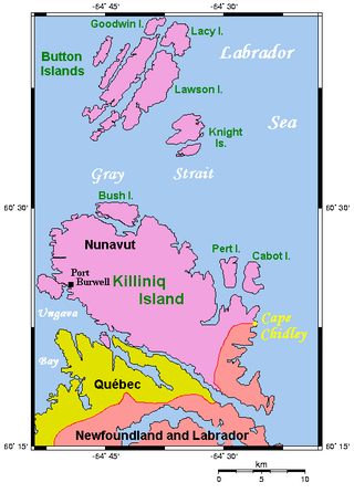
Cape Chidley is a headland located on the eastern shore of Killiniq Island, Canada, at the northeastern tip of the Labrador Peninsula.

The Torngat Mountains are a mountain range on the Labrador Peninsula at the northern tip of Newfoundland and Labrador and eastern Quebec. They are part of the Arctic Cordillera. The mountains form a peninsula that separates Ungava Bay from the Atlantic Ocean.

The North Warning System is a joint United States and Canadian early-warning radar system for the atmospheric air defense of North America. It provides surveillance of airspace from potential incursions or attacks from across North America's polar region. It replaced the Distant Early Warning Line system in the late 1980s.

Hopedale is a town located in the north of Labrador, the mainland portion of the Canadian province of Newfoundland and Labrador. Hopedale is the legislative capital of the Inuit Land Claims Area Nunatsiavut, and where the Nunatsiavut Assembly meets. As of the 2021 census, it has a population of 596.

Torngat Mountains National Park is a Canadian national park located on the Quebec-Labrador Peninsula in the province of Newfoundland and Labrador. The park encompasses 9,700 km2 of mountainous terrain between Northern Quebec and the Labrador Sea. It is the largest national park in Atlantic Canada and the southernmost national park in the Arctic Cordillera. It partially contains the Torngat Mountains, the highest mountains in mainland Canada east of the Rocky Mountains.

Canadian Forces Station Saglek is a Royal Canadian Air Force radar base in the former Pinetree Line and currently part of the North Warning System, located near Saglek Bay in Newfoundland and Labrador, 367.7 miles (591.8 km) north-northwest of CFB Goose Bay.
Makkovik is a town in Labrador in eastern Canada. It had 365 residents in 2021. The main industry is snow crabbing and there is a fishing cooperative.
Killiniq Island is a remote island in southeastern Nunavut and northern Newfoundland and Labrador, Canada. Located at the extreme northern tip of Labrador between Ungava Bay and the Labrador Sea, it is notable in that it contains the only land border between Nunavut and Newfoundland and Labrador. Most other islands off the northern coast of Quebec and Labrador belong exclusively to Nunavut. Some cartographic sources do not correctly show the island's geopolitical boundaries; for instance, the Commission de toponymie du Québec seems to show it as belonging to Quebec.

Barter Island LRRS Airport is a public/military airport located near the city of Kaktovik on Barter Island, in the North Slope Borough, located 312 miles (502 km) east of Point Barrow, Alaska. The airport is owned by the North Slope Borough. It is also known as Barter Island Airport or Kaktovik Airport. The acronym LRRS stands for Long Range Radar Site or Long Range Radar Station.
Point Lay LRRS Airport is a public and military use airport owned by the United States Government and located in Point Lay, in the North Slope Borough of the U.S. state of Alaska. It is also known as Point Lay Airport. The acronym LRRS stands for Long Range Radar Site or Long Range Radar Station.
Point Lonely Short Range Radar Site is a United States Air Force Short Range Radar Site located in the North Slope Borough of the U.S. state of Alaska, 84 miles (135 km) east-southeast of Point Barrow, Alaska. It is not open for public access.

In Labrador, Canada, the North Atlantic Craton is known as the Nain Province. The Nain geologic province was intruded by the Nain Plutonic Suite, which divides the province into the northern Saglek block and the southern Hopedale block.

Hopedale Air Station is a General Surveillance Radar station that the USAF closed in 1968. It is located north of the community of Hopedale, Newfoundland and Labrador 147.8 miles (237.9 km) west-northwest of CFB Goose Bay, Newfoundland and Labrador, Canada.

La Scie Air Station was a General Surveillance Gap Filler Radar station in the Canadian province of Newfoundland and Labrador, It was located 210 miles (340 km) east-northeast of St.John's, Near La Scie. It was closed in 1961.

Cut Throat Island Air Station was a General Surveillance Gap Filler Radar station in the Canadian province of Newfoundland and Labrador, It was located 160 miles (260 km) east-northeast of CFB Goose Bay. It was closed in 1961.
Spotted Island Air Station was a General Surveillance Gap Filler Radar station in the Canadian province of Newfoundland and Labrador, It was located 195 miles (314 km) east of CFB Goose Bay. It was closed in 1961.
Fox Harbour Air Station was a General Surveillance Gap Filler Radar station in St. Lewis in the Canadian province of Newfoundland and Labrador, It was located 210 miles (340 km) southeast of CFB Goose Bay. It was closed in 1961.
Cartwright Long Range Radar Site (LAB-6) is a Royal Canadian Air Force Long Range Radar Site located 233.7 kilometres (145.2 mi) east-northeast of CFB Goose Bay, Newfoundland and Labrador.
Cape Kakiviak Short Range Radar Site (LAB-1) is a Royal Canadian Air Force Short Range Radar Site located in the Torngat Mountains of northern Labrador, 505 miles (813 km) north of CFB Goose Bay, Newfoundland and Labrador.
Canadian Forces Station Moisie, also known as CFS Moisie, is a former Canadian Forces Station located in the community of Moisie, Quebec.


