Sainte-Catherine-de-Fierbois | |
---|---|
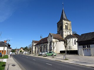
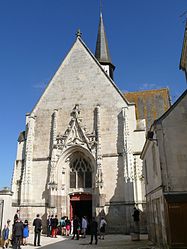
![]() The church of Sainte-Catherine, in Sainte-Catherine-de-Fierbois | |
Coordinates: 47°09′30″N0°39′16″E / 47.1583°N 0.6544°E | |
Country | France |
Region | Centre-Val de Loire |
Department | Indre-et-Loire |
Arrondissement | Tours |
Canton | Sainte-Maure-de-Touraine |
Government | |
• Mayor (2020–2026) | Jean-Michel Pagé [1] |
Area 1 | 15.49 km2 (5.98 sq mi) |
Population | 785 |
• Density | 51/km2 (130/sq mi) |
Time zone | UTC+01:00 (CET) |
• Summer (DST) | UTC+02:00 (CEST) |
INSEE/Postal code | 37212 /37800 |
Elevation | 92–129 m (302–423 ft) |
1 French Land Register data, which excludes lakes, ponds, glaciers > 1 km2 (0.386 sq mi or 247 acres) and river estuaries. |
Sainte-Catherine-de-Fierbois (French pronunciation: [sɛ̃tkatʁindəfjɛʁbwa] ) is a commune in the Indre-et-Loire department in central France. [3] During the Hundred Years' War, an ancient sword was found buried behind the altar of this chapel by St Joan of Arc, with the help of the divine counsel of St. Michael the Archangel, St. Catherine of Alexandria, St. Margaret of Antioch, and other saints. With the sword, she led the French to victory, retaking Orléans and vanquishing the English forts surrounding it.
It is a stop on the Way of St. James. [4]
Year | Pop. | ±% p.a. |
---|---|---|
1968 | 499 | — |
1975 | 529 | +0.84% |
1982 | 484 | −1.26% |
1990 | 539 | +1.35% |
1999 | 611 | +1.40% |
2007 | 653 | +0.83% |
2012 | 700 | +1.40% |
2017 | 761 | +1.69% |
Source: INSEE [5] |
Indre-et-Loire is a department in west-central France named after the Indre River and Loire River. In 2019, it had a population of 610,079. Sometimes referred to as Touraine, the name of the historic region, it nowadays is part of the Centre-Val de Loire region. Its prefecture is Tours and subprefectures are Chinon and Loches. Indre-et-Loire is a touristic destination for its numerous monuments that are part of the Châteaux of the Loire Valley.
Sainte-Catherine may refer to:
Vouvray is a commune in the Indre-et-Loire department in central France. It is around 9 km east of the centre of Tours.
The arrondissement of Tours is an arrondissement of France in the Indre-et-Loire department in the Centre-Val de Loire region. It has 54 communes. Its population is 384,117 (2016), and its area is 1,087.6 km2 (419.9 sq mi).
Sazeray is a commune in the Indre department in central France, in the region of Centre-Val de Loire.
Saint-Cyr-sur-Loire is a commune in the department of Indre-et-Loire in central France.
Abilly is a commune in the Indre-et-Loire department in central France.
Saint-Laurent-de-Lin is a commune in the Indre-et-Loire department in central France.
Sainte-Maure-de-Touraine is a commune in the French department of Indre-et-Loire, Centre-Val de Loire.
Saint-Étienne-de-Chigny is a commune in the Indre-et-Loire department in central France.
Saint-Martin-le-Beau is a commune in the Indre-et-Loire department in central France.
Saint-Paterne-Racan is a commune in the Indre-et-Loire department in central France.
Saint-Branchs is a commune in the Indre-et-Loire department in central France.
Chouzé-sur-Loire is a commune in the Indre-et-Loire department in central France.
Savonnières is a commune in the Indre-et-Loire department in central France.
Esvres, also called Esvres-sur-Indre, is a commune in the department of Indre-et-Loire, in the administrative region of Centre-Val de Loire in central France.
Monnaie is a commune in the Indre-et-Loire department in central France.
Veigné is a commune in the Indre-et-Loire department in central France.
La Riche is a commune in the Indre-et-Loire department in central France. It is part of the agglomeration of Tours.
The canton of Sainte-Maure-de-Touraine is an administrative division of the Indre-et-Loire department, central France. Its borders were modified at the French canton reorganisation which came into effect in March 2015. Its seat is in Sainte-Maure-de-Touraine.