Bléré

Last updated • 1 min readFrom Wikipedia, The Free Encyclopedia

Bléré
Chapelle Jehan de Saignes. Blere (Indre-et-Loire)..jpg
The Chapel of Jehan de Saignés, in Bléré
Blason de la ville de Blere (37).svg
Location of Bléré
Blere
France location map-Regions and departements-2016.svg
Red pog.svg
Bléré
Centre-Val de Loire region location map.svg
Red pog.svg
Bléré
Coordinates: 47°19′33″N0°59′26″E / 47.3258°N 0.9906°E / 47.3258; 0.9906
Country France
Region Centre-Val de Loire
Department Indre-et-Loire
Arrondissement Loches
Canton Bléré
Government
  Mayor (20202026) Fabien Nebel [1]
Area
1
30.8 km2 (11.9 sq mi)
Population
 (Jan. 2021) [2]
5,280
  Density170/km2 (440/sq mi)
Time zone UTC+01:00 (CET)
  Summer (DST) UTC+02:00 (CEST)
INSEE/Postal code
37027 /37150
Elevation52–112 m (171–367 ft)
1 French Land Register data, which excludes lakes, ponds, glaciers > 1 km2 (0.386 sq mi or 247 acres) and river estuaries.

Bléré (French pronunciation: [bleʁe] ) is a commune in the Indre-et-Loire department in central France.

Contents

Geography

Cultural surroundings

Bléré, in the administrative region of "Centre Val-de-Loire", is located 27 km from Tours, 225 km southwest of Paris, and is close to the great châteaux of the Loire Valley. It is close to:

The town of Bléré is located in the Cher valley and in a rather wooded agricultural and wine region.

Transport Network

Main highways

The A85 motorway goes through the south of the city connecting the cities of Angers and Vierzon, its exit 11 allows you to reach the city.

The A10 (or E60) motorway passes through the town of Auzouer-en-Touraine 30.5 km from Bléré.

Connections to intercity road and rail connections

Bléré-La Croix is a train station served by the TER Centre-Val de Loire connecting the cities of Tours, Bléré, Saint-Aignan, Vierzon, Bourges and Nevers. [3]

Line D of the interurban mobility network (or REMI) connecting the Bléré-Tours terminals serves four stops in Bléré.

Population

Historical population
YearPop.±% p.a.
1793 2,153    
1800 2,519+2.27%
1806 2,475−0.29%
1821 2,663+0.49%
1831 2,948+1.02%
1836 2,978+0.20%
1841 3,417+2.79%
1846 3,493+0.44%
1851 3,676+1.03%
1856 3,431−1.37%
1861 3,477+0.27%
1866 3,561+0.48%
1872 3,510−0.24%
1876 3,675+1.16%
1881 3,688+0.07%
1886 3,599−0.49%
1891 3,272−1.89%
1896 3,269−0.02%
YearPop.±% p.a.
1901 3,288+0.12%
1906 3,342+0.33%
1911 3,533+1.12%
1921 3,156−1.12%
1926 3,160+0.03%
1931 3,041−0.76%
1936 3,070+0.19%
1946 3,250+0.57%
1954 3,420+0.64%
1962 3,450+0.11%
1968 3,832+1.77%
1975 4,113+1.02%
1982 4,057−0.20%
1990 4,388+0.99%
1999 4,576+0.47%
2007 5,045+1.23%
2012 5,250+0.80%
2017 5,272+0.08%
Source: EHESS [4] and INSEE (1968-2017) [5]

International relations

Bléré is twinned with:

[6] [7]

See also

Related Research Articles

<span class="mw-page-title-main">Indre-et-Loire</span> Department of France in Centre-Val de Loire

Indre-et-Loire is a department in west-central France named after the Indre River and Loire River. In 2019, it had a population of 610,079. Sometimes referred to as Touraine, the name of the historic region, it nowadays is part of the Centre-Val de Loire region. Its prefecture is Tours and subprefectures are Chinon and Loches. Indre-et-Loire is a touristic destination for its numerous monuments that are part of the Châteaux of the Loire Valley.

<span class="mw-page-title-main">Chenonceaux</span> Commune in Centre-Val de Loire, France

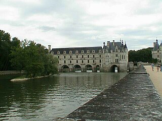
Chenonceaux is a commune in the French department of Indre-et-Loire, and the region of Centre-Val de Loire, France.

<span class="mw-page-title-main">Loir-et-Cher</span> Department of France

Loir-et-Cher is a department in the Centre-Val de Loire region of France. Its name is originated from two rivers which cross it, the Loir in its northern part and the Cher in its southern part. Its prefecture is Blois. The INSEE and La Poste gave it the number 41. It had a population of 329,470 in 2019.

<span class="mw-page-title-main">Communes of the Indre-et-Loire department</span>

The following is a list of the 272 communes of the Indre-et-Loire department of France.

<span class="mw-page-title-main">Centre-Val de Loire</span> Administrative region of France

Centre-Val de Loire or Centre Region, as it was known until 2015, is one of the eighteen administrative regions of France. It straddles the middle Loire Valley in the interior of the country, with a population of 2,572,853 as of 2018. Its prefecture is Orléans, and its largest city is Tours.

<span class="mw-page-title-main">Fondettes</span> Commune in Centre-Val de Loire, France

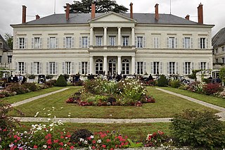
Fondettes is a commune in the suburbs of Tours in the Indre-et-Loire department in the Centre-Val de Loire region.

<span class="mw-page-title-main">Descartes, Indre-et-Loire</span> Commune in Centre-Val de Loire, France

Descartes is a large village and commune in the Indre-et-Loire department in central France. It is approximately 29 kilometers east of Richelieu and about 48 kilometers east of Loudun, on the banks of the Creuse River, near the border of the French department of Vienne, and the border of the region between Centre-Val de Loire and Nouvelle-Aquitaine. It is famous for the birthplace of the French mathematician and philosopher who invented the Cartesian coordinate system, René Descartes.

<span class="mw-page-title-main">Arrondissement of Tours</span> Arrondissement in Centre-Val de Loire, France

The arrondissement of Tours is an arrondissement of France in the Indre-et-Loire department in the Centre-Val de Loire region. It has 54 communes. Its population is 384,117 (2016), and its area is 1,087.6 km2 (419.9 sq mi).

<span class="mw-page-title-main">Arrondissement of Loches</span> Arrondissement in Centre-Val de Loire, France

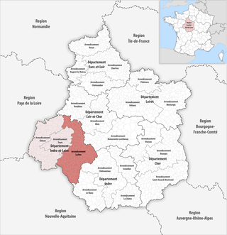
The arrondissement of Loches is an arrondissement of France in the Indre-et-Loire department in the Centre-Val de Loire region. It has 112 communes. Its population is 118,282 (2016), and its area is 2,742.5 km2 (1,058.9 sq mi).

<span class="mw-page-title-main">Montegiardino</span> Castello in San Marino

Montegiardino is one of the 9 communes or castelli of San Marino. It has 967 inhabitants in an area of 3.31 km2.

Genouilly is a commune in the Cher department in the Centre-Val de Loire region of France.

<span class="mw-page-title-main">Quincy, Cher</span> Commune in Centre-Val de Loire, France

Quincy is a commune in the Cher department in the Centre-Val de Loire region of France.

Dampierre-en-Graçay is a commune in the Cher department in the Centre-Val de Loire region of France.

<span class="mw-page-title-main">Foëcy</span> Commune in Centre-Val de Loire, France

Foëcy is a commune in the Cher department in the Centre-Val de Loire region of France.

<span class="mw-page-title-main">Tournon-Saint-Martin</span> Commune in Centre-Val de Loire, France

Tournon-Saint-Martin is a commune in the Indre department in central France.

<span class="mw-page-title-main">Saint-Pierre-des-Corps</span> Commune in Centre-Val de Loire, France

Saint-Pierre-des-Corps is a commune in the French department of Indre-et-Loire, Centre-Val de Loire, France. It is located about 4 km (2.5 mi) from Tours. During the French Revolution, it was called La Clarté-Républicaine.

<span class="mw-page-title-main">Sorigny</span> Commune in Centre-Val de Loire, France

Sorigny is a French commune in the Indre-et-Loire department, Centre-Val de Loire.

Esvres, also called Esvres-sur-Indre, is a commune in the department of Indre-et-Loire, in the administrative region of Centre-Val de Loire in central France.

<span class="mw-page-title-main">Saint-Pierre-des-Corps station</span>

Saint-Pierre-des-Corps station is a railway station serving the town of Saint-Pierre-des-Corps and the Tours agglomeration, Indre-et-Loire department, western France. It is situated on the Paris–Bordeaux railway and the Tours–Saint-Nazaire railway.

<span class="mw-page-title-main">Tours station</span>

Tours station is a railway station serving the city of Tours, Indre-et-Loire department, western France. It is situated on the Paris–Bordeaux railway, the Tours–Saint-Nazaire railway, and the non-electrified Tours–Le Mans railway. The Gare de Tours is a terminus; most TGV trains only serve the nearby Gare de Saint-Pierre-des-Corps.

References

  1. "Répertoire national des élus: les maires" (in French). data.gouv.fr, Plateforme ouverte des données publiques françaises. 13 September 2022.
  2. "Populations légales 2021". The National Institute of Statistics and Economic Studies. 28 December 2023.
  3. "Bléré la Croix Gares & Connexions". www.garesetconnexions.sncf.
  4. Des villages de Cassini aux communes d'aujourd'hui: Commune data sheet Bléré, EHESS (in French).
  5. Population en historique depuis 1968, INSEE
  6. "Rinnovato il gemellaggio tra Montegiardino (San Marino) e Bléré (Francia)" (in Italian). Retrieved 14 January 2024.
  7. "Bléré - Montegiardino, le jumelage prend le nom de San-to" (in French). Retrieved 14 January 2024.