San Gorgonio Pass Wind Farm

Last updated
San Gorgonio Pass Wind Farm
San Gorgonio Pass Wind Farm IMG 0504.JPG
Relief map of California.png
Red pog.svg
Location of San Gorgonio Pass Wind Farm
Country United States
Location Riverside County, California
Coordinates 33°54′N116°35′W / 33.900°N 116.583°W / 33.900; -116.583 Coordinates: 33°54′N116°35′W / 33.900°N 116.583°W / 33.900; -116.583
Status Operational
Construction began 1980s
Wind farm
Hub height 160 ft (49 m) (max)
Power generation
Units operational 3,218
Nameplate capacity 615 MW

The San Gorgonio Pass Wind Farm is a wind farm located on the eastern slope of the San Gorgonio Pass in Riverside County, just east of White Water, California, United States. Developed beginning in the 1980s, it is one of three major wind farms in California, along with those at Altamont and the Tehachapi passes. The gateway into the Coachella Valley, the San Gorgonio Pass is one of the windiest places in southern California.

Wind farm group of wind turbines

A wind farm or wind park is a group of wind turbines in the same location used to produce electricity. A large wind farm may consist of several hundred individual wind turbines and cover an extended area of hundreds of square miles, but the land between the turbines may be used for agricultural or other purposes. A wind farm can also be located offshore.

San Gorgonio Pass Pass between San Bernardino Mountains and San Jacinto Mountains in California, United States

San Gorgonio Pass, sometimes incorrectly referred to as Banning Pass due to the location of Banning, California about 6.5 miles east of the pass summit, el. 2,600 ft (790 m), is a gap on the rim of the Great Basin between the San Bernardino Mountains to the north and the San Jacinto Mountains to the south, carrying Interstate 10 and the Union Pacific Railroad between the Los Angeles basin and the Coachella Valley. Like Cajon Pass to the northwest, it was created by the San Andreas Fault, with the valleys leading up to the pass aligned with the fault. The pass is not as steep as Cajon or Tejon passes, but it is one of the deepest mountain passes in the 48 contiguous states, with the mountains to either side rising almost 9,000 ft (2,700 m) above it. San Gorgonio Mountain, taller but farther away and less visible, is at the northern side of the pass, and Mount San Jacinto is on the southern side. Mount San Jacinto has the fifth-largest rock wall in North America, and its peak is only six miles south of Interstate 10. Today, San Gorgonio Pass is used by commuters from the Greater San Bernardino Area to travel through the mountains to Palm Springs and the Coachella Valley, and points further east, all the way to Phoenix, Arizona.

Riverside County, California County in California, United States

Riverside County, is one of fifty-eight counties in the U.S. state of California. As of the 2010 census, the population was 2,189,641, making it the 4th-most populous county in California and the 11th-most populous in the United States. The name was derived from the city of Riverside, which is the county seat.

Contents

Utilities

As of January 2008, the farm consists of 3,218 units delivering 615 MW. [1] A single Southern California Edison Path 46 500 kilo-volt power line crosses the pass on the northern edge of San Jacinto Peak. This line links the Los Angeles metro area with the Palo Verde Nuclear Power Plant.

Southern California Edison electrical utility in Southern California, USA

Southern California Edison, the largest subsidiary of Edison International, is the primary electricity supply company for much of Southern California. It provides 14 million people with electricity across a service territory of approximately 50,000 square miles. However, the Los Angeles Department of Water and Power, San Diego Gas & Electric, Imperial Irrigation District, and some smaller municipal utilities serve substantial portions of the southern California territory. The northern part of the state is generally served by the Pacific Gas & Electric Company of San Francisco.

Path 46, also called West of Colorado River, Arizona-California West-of-the-River Path (WOR), is a set of many high-voltage alternating-current transmission lines that are located in southeast California and Nevada up to the Colorado River. This power transmission system is essential to meet the electricity demands of Southern California's massive population centers like Los Angeles and San Diego. The massive system has three separate systems of power lines.

Volt SI derived unit of voltage

The volt is the derived unit for electric potential, electric potential difference (voltage), and electromotive force. It is named after the Italian physicist Alessandro Volta (1745–1827).

San gorgonio pass wind farm california pano.jpg
The majority of the San Gorgonio Pass Wind Farm viewed from atop the Palm Springs Aerial Tramway in the San Jacinto Mountains to the south. The farm continues over the hills to the north along California State Route 62. Interstate 10 traverses the image horizontally, and a small portion of State Route 111 is also visible at the bottom of the photo.

History and governance

Wind energy development in the San Gorgonio Pass area was formally studied through the San Gorgonio Wind Resource Study EIR (1982), a joint environmental document prepared for the U.S. Bureau of Land Management and Riverside County. The document assessed three scenarios for wind energy development in the area and included criteria for the development of wind energy on both a countywide basis and specifically for the San Gorgonio Pass area. [2] Since 1982, and the approval of wind energy development in the San Gorgonio Pass, numerous wind turbines have become part of the landscape. The narrow turbines range from 80 to 160 feet in height. [3]

Involvement with ExxonMobil

In August 1997, ExxonMobil and Southern California Edison jointly constructed a combination oil refinery and storage facility. The plant continues to operate as a refinery while at the same time storing a healthy oil reserve. The refinery and storage facility works in tandem with the wind farm to utilize the energy created in the necessary processes in the refinery process. [4]

Further information

Huell Howser American television personality

Huell Burnley Howser was an American television personality, actor, producer, writer, singer, and voice artist, best known for hosting, producing, and writing California's Gold, his human interest show produced by KCET in Los Angeles for California PBS stations. The archive of his video chronicles offers an enhanced understanding of the history, culture, and people of California. He also voiced the Backson in Winnie the Pooh (2011).

KCET, virtual and UHF digital channel 28, is a non-commercial educational, independent television station licensed to Los Angeles, California, United States. Owned by the Public Media Group of Southern California, it is sister to Huntington Beach-licensed Public Broadcasting Service (PBS) member station KOCE-TV. KCET's studios are located at The Pointe in Burbank, and its transmitter is located atop Mount Wilson in the San Gabriel Mountains.

California's Gold is a public television human interest program that explores the natural, cultural, and historical features of California. The series ran for 24 seasons beginning in 1991, and was produced and hosted by Huell Howser in collaboration with KCET, Los Angeles. The series ceased production when Howser retired in November 2012, shortly before his death on January 7, 2013, although episodes continued to be shown for some time after his death.

See also

Related Research Articles

Ludington Pumped Storage Power Plant

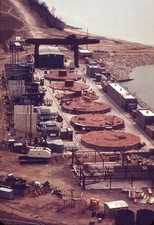
The Ludington Pumped Storage Plant is a hydroelectric plant and reservoir in Ludington, Michigan. It was built between 1969 and 1973 at a cost of $315 million and is owned jointly by Consumers Energy and DTE Energy and operated by Consumers Energy. At the time of its construction, it was the largest pumped storage hydroelectric facility in the world.

Fawley, Hampshire village in United Kingdom

Fawley is a village and civil parish in Hampshire, England. It is situated in the New Forest on the western shore of the Solent, approximately 7 miles south of Southampton. Fawley is also the site of Fawley Refinery, operated by ExxonMobil, which is the largest facility of its kind in the United Kingdom. The decommissioned Fawley Power Station is also located less than a mile to the south east of the village.

Daggett, California Unincorporated community in California, United States

Daggett is an unincorporated community located in San Bernardino County, California in the United States. The town is located on Interstate 40 ten miles (16 km) east of Barstow. The town has a population of about 200. The ZIP code is 92327 and the community is inside area code 760.

Baton Rouge Refinery

ExxonMobil's Baton Rouge Refinery in Baton Rouge, Louisiana is the fourth-largest oil refinery in the United States and twelfth-largest in the world, with an input capacity of 502,500 barrels (79,890 m3) per day as of January 1, 2016. The refinery is the site of the first commercial fluid catalytic cracking plant that began processing at the refinery on May 25, 1942.

The Solar Project

The SOLAR Project consists of the Solar One, Solar Two and Solar Tres solar thermal power plants based in the Mojave Desert, United States and Andalucía, Spain. The US Department of Energy (DOE) and a consortium of US utilities built this country's first two large-scale, demonstration solar power towers in the desert near Barstow, California.

Altamont Pass wind farm

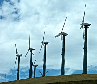
The Altamont Pass wind farm is located in the Altamont Pass of the Diablo Range in Northern California. It is one of the earliest wind farms in the United States. The first wind turbines were placed on the Altamont in the early 1980s by Fayette Manufacturing Corporation on land owned by cattle rancher Joe Jess. The wind farm is composed of 4930 relatively small wind turbines of various types, making it at one time the largest wind farm in the world in terms of capacity. Altamont Pass is still one of the largest concentration of wind turbines in the world, with a capacity of 576 megawatts (MW), producing about 125 MW on average and 1.1 terawatt-hours (TWh) yearly. They were installed after the 1970s energy crisis in response to favorable tax policies for investors.

Tehachapi Pass wind farm

The Tehachapi Pass wind farm is one of the first large-scale wind farms installed in the U.S., with around 700 MW capacity.

Wind power in the United States

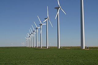
Wind power in the United States is a branch of the energy industry that has expanded quickly over the latest several years. For the twelve months through November 2017, 254.2 terawatt-hours were generated by wind power, or 6.33% of all generated electrical energy.

Wind power in Texas

Wind power in Texas consists of many wind farms with a total installed nameplate capacity of 22,637 MW from over 40 different projects. Texas produces the most wind power of any U.S. state. According to ERCOT, wind power accounted for at least 15.7% of the electricity generated in Texas during 2017, as wind was 17.4% of electricity generated in ERCOT, which manages 90% of Texas's power.

Wind power in California

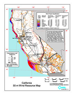
Wind power has a long history in the state of California, with the initiative and early development occurring during Governor Jerry Brown's first two terms in the late 1970s and early 1980s. California's wind power capacity has grown by nearly 350% since 2001, when it was less than 1,700 MW. In 2016, wind energy now supplies about 6.9% of California's total electricity needs, or enough to power more than 1.3 million households. Most of California's wind generation is found in the Tehachapi area of Kern County, California, with some big projects in Solano, Contra Costa and Riverside counties as well. California is among the states with the largest amount of installed wind power capacity. In recent years, California has lagged behind other states when it comes to the installation of wind power. It was ranked 4th overall for wind power electrical generation at the end of 2016 behind Texas, Iowa, and Oklahoma. As of December 31, 2016, California had 5,662 megawatts (MW) of wind powered electricity generating capacity.

Fossil fuels lobby

"Fossil fuels lobby" is the umbrella term used to name the paid representatives of large fossil fuel and electric utilities corporations who attempt to influence governmental policy. So-called Big Oil companies such as ExxonMobil, Royal Dutch Shell, BP, Total S.A., Chevron Corporation, and ConocoPhillips are amongst the largest corporations associated with the fossil fuels lobby. General Electric, Southern Company, First Energy, and the Edison Electric Institute are also among the most influential electric utilities corporations. However, electric companies and big oil and gas companies are consistently not among the ten highest-spending lobbyists – the United States Chamber of Commerce is currently #1. By sector, "Energy/Nat Resource" comes fifth, behind "Misc Business", "Finance/Insur/RealEst", Health and "Communic/Electronics".

Fawley Refinery British oil refinery owned by ExxonMobil

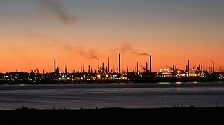
Fawley Refinery is an oil refinery located at Fawley, Hampshire, England. The refinery is owned by Esso, which acquired the site in 1925. Situated on Southampton Water, it was rebuilt and extended in 1951 and is now the largest oil refinery in the United Kingdom, and one of the most complex refineries in Europe. With a capacity of 270,000 barrels a day, Fawley provides 20 percent of UK refinery capacity. An estimated 2,300 people are employed at the site.

BrightSource Energy company

BrightSource Energy, Inc. is an Oakland, California based, corporation that designs, builds, finances, and operates utility-scale solar power plants.

Shepherds Flat Wind Farm wind farm

The Shepherds Flat Wind Farm is an 845 megawatt (MW) wind farm in the U.S. state of Oregon. The facility is located in Eastern Oregon in both Morrow and Gilliam counties, near Arlington. Approved in 2008 by state regulators, groundbreaking came in 2009. The wind farm was built by Caithness Energy using General Electric (GE) 2.5 MW wind turbines, and it supplies electricity to Southern California Edison. The wind farm is estimated to have an economic impact of $16 million annually for Oregon. It is one of the largest land-based wind farms in the world. It officially opened in September 2012.

Exxon Mobil Corporation, doing business as ExxonMobil, is an American multinational oil and gas corporation headquartered in Irving, Texas. It is the largest direct descendant of John D. Rockefeller's Standard Oil Company, and was formed on November 30, 1999 by the merger of Exxon and Mobil. ExxonMobil's primary brands are Exxon, Mobil, Esso, and ExxonMobil Chemical.

Alta Wind Energy Center

Alta Wind Energy Center (AWEC), also known as Mojave Wind Farm, is the third largest onshore wind energy project in the world. The Alta Wind Energy Center is a wind farm located in Tehachapi Pass of the Tehachapi Mountains, in Kern County, California. As of 2013, it is the largest wind farm in the United States, with a combined installed capacity of 1,547 MW (2,075,000 hp). The project, being developed near Tehachapi Pass Wind Farm— site of the first large-scale wind farms installed in the U.S. in the 1970s and 1980s—is "a powerful illustration of the growing size and scope of modern wind projects".

The Benicia Refinery is an oil refinery located near the San Francisco Bay Area city of Benicia, California. The refinery is owned by Valero Energy Corporation.

California is the most populous state in the nation, but its total energy demand is second to the state of Texas. The state has one of the lowest per capita energy consumption rates in the country due in part to the relatively mild weather comparative to the rest of the nation.

References

  1. U.S. Wind Energy Projects - California Archived 2010-08-07 at the Wayback Machine .
  2. San Gorgonio Pass Wind Energy Policy Area
  3. U.S. DEPARTMENT OF THE INTERIOR BUREAU OF LAND MANAGEMENT DOI-BLM-CA-060-0007-0057-EA Archived 2012-09-16 at the Wayback Machine .
  4. ExxonMobil
  5. California's Gold / #909: Big Things in the Desert. OCLC   45819663 , 78285388 , 719655627
  6. California's Green / Wind Power. Edited by Michael Garber. DVD. 30 minutes. OCLC   747281801