The Zuari River is the largest river in the state of Goa, India. It is a tidal river. The Zuari originates at Hemad-Barshem in the Western Ghats. The Zuari is also referred to as the Aghanashani in the interior regions. It flows in the southern-western direction through the talukas of Tiswadi, Ponda, Mormugao, Salcete, Sanguem and Quepem.
Salcete or Salcette is a sub-division of the district of South Goa in the Indian state of Goa. Its administrative and economic headquarters is Margao. It is largely co-terminous with a region called Saxti, which comprised, by local tradition, sixty-six villages, hence the name. However, Saxti also included the now separate sub-district of Mormugao.

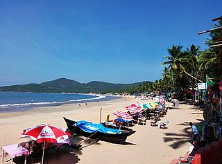
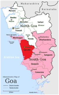
South Goa is one of two districts that comprises the state of Goa in West India, within the region known as the Konkan. It is bounded by the district of North Goa to the north, the Uttara Kannada district of Karnataka state to the east and south, while the Arabian Sea forms its western coast.

Sanguem is a city and a municipal council in South Goa district in the Indian state of Goa. Notable landmarks include the Sagameshwar Temple, Bhagwan Mahaveer Sanctuary and Mollem National Park and the Salaulim Dam.

Pernem is a northmost administrative region or sub-district in North Goa.It acts as the Gateway of Goa from Maharashtra side. It is also the name of the town of Pernem, which is its headquarters. It has a Municipal Council. Geographically, Pernem is surrounded by Sawantwadi sub-district on East, Arabian Sea on West, Bardez and Bicholim sub-district on south and Sawantwadi sub-district on north.The two rivers which decide the boundary of this sub-district are Terekhol River and Chapora River. Terekhol river acts as a border of Maharashtra and Goa while Chapora river acts as a border of Pernem sub-district and Bardez sub-district.
Curchorem (Kudchade) is a town and municipal council in the South Goa district of Goa, and is part of Quepem taluka. Curchorem and Sanvordem are twin towns on either side of the Zuari River. The town is self-sufficient and has a number of hospitals, schools, a police station, banks, ATMs, a railway station, good road links, a market, places of worship, restaurants, a play ground, an electricity station and a theatre.

Bhagwan Mahaveer Sanctuary and Mollem National Park is a 240 square kilometres (93 sq mi) protected area located in the Western Ghats of South India, in Sanguem taluk, Goa along the eastern border with Karnataka. The area is situated near the town of Molem, 57 kilometres (35 mi) east of Panaji, the state capital of Goa. National Highway 4A divides it into two parts and the Mormugao - Londa railway line passes through the area. It is located between 15°15"30' to 15°29"30' N and 74°10"15' to 74°20"15' E. It contains several important temples dating to the Kadamba Dynasty, and Dudhsagar Falls. The parkland is also home to a community of nomadic buffalo herders known as the Dhangar.
South Goa Lok Sabha constituency is one of two Lok Sabha (parliamentary) constituencies in Goa in western India along with North Goa.
Vimaleshwar Temple is located in Rivona village of Sanguem taluka in the state of Goa, India. Vimaleshwar is a form of Shiva and is worshiped in the form of a Shivalinga. It is a "Swayambhu" shivlinga.

Quepem is a sub-division of South Goa district in the state of Goa, India. It is an administrative region of Goa, India.

The Salaulim Dam located on the Salaulim River, a tributary of the Zuari River in Goa, India, is an integral component of the Salaulim Irrigation Project which envisages benefits of irrigation and drinking water supply. The dam is a composite earth-cum-masonry dam of 42.7 metres (140 ft) height with a water spread area of 24 km2 (9.3 sq mi).

Dharbandora is a sub-division of Goa, India. It came into existence as a part of the South Goa district on 4 April 2012. Five panchayats, Dharbandora, Kirlapal-Dabhal, Collem, Mollem and Sancorda from the Sanguem sub-division were incorporated into the new sub-division. The sub-division at present has a population of 30,000 to 40,000 people.
Sanguem Vidhan Sabha Constituency is one of the 40 Goa Legislative Assembly constituencies of the state of Goa in southern India. Sanguem is also one of the 20 constituencies falling under the South Goa Lok Sabha constituency.
Kalem railway station is a small railway station in South Goa district, Goa. Its code is KM. It serves Sanguem town. The station consists of one platform. The platform is not well sheltered. It lacks many facilities including water and sanitation.