Santee, South Carolina

Last updated

Santee, South Carolina
LM18hole.jpg
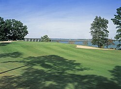
The 18th hole at the Santee-Cooper Country Club, showing the I-95 causeway crossing Lake Marion at Santee
Motto: 
"It's a Brand New Day in Santee"
SCMap-doton-Santee.PNG
Coordinates: 33°29′N80°29′W / 33.483°N 80.483°W / 33.483; -80.483
Country United States
State South Carolina
County Orangeburg
Government
  Type Mayor–council government
  MayorDonnie Hilliard
Area
[1]
  Total2.44 sq mi (6.33 km2)
  Land2.43 sq mi (6.28 km2)
  Water0.02 sq mi (0.05 km2)
Elevation
138 ft (42 m)
Population
 (2020) [2]
  Total797
  Density328.52/sq mi (126.86/km2)
Time zone UTC-5 (EST)
  Summer (DST) UTC-4 (EDT)
ZIP code
29142
Area code(s) 803, 839
FIPS code 45-63790 [3]
GNIS feature ID1231775 [4]
Website townofsantee-sc.org

Santee is a town in Orangeburg County along the Santee River Valley in central South Carolina, United States. It has become a resort town of note located centrally north-south along the Atlantic Seaboard of South Carolina. The region has been rural, with a primarily agricultural economy typical of Orangeburg County, but is now known primarily for its several golf courses in proximity to Lake Marion, Santee State Park and other Lake Marion attractions. Interstate 95 connects its attractions easily with tourists traveling by automobile. I-95 crosses a narrow arm of the lake into the town lands, along a causeway. Lake Marion is a man-made hydroelectric reservoir, which at 110,000 acres (450 km2, 173 sq mi) is one of the fifty largest lakes in the country.

Contents

The population was 797 at the 2020 census. The town has been undergoing economic and population growth, and development as rural niches are supplanted by bedroom communities.

Construction of the Santee Cooper Regional Water System can provide millions of gallons of potable water per day to the surrounding five counties centered about Santee. The system was coordinated by the U.S. Department of Agriculture and funded by the Army Corps of Engineers, USEPA, and the South Carolina Department of Commerce. The plant was completed and operational as of 1 June 2008. Work to connect the plant to the five counties (Berkeley, Orangeburg, Dorchester, Calhoun, and Sumter) is underway and being overseen and funded by the same parties. Currently, the RWS serves the town of Santee, with pipeline rapidly being installed to other locations. [5] Incoming businesses from this project are projected to bring thousands of jobs to the area. [6]

The Lake Marion High School & Technology Center is located in the town.

Geography

Santee is located at 33°29′N80°29′W / 33.483°N 80.483°W / 33.483; -80.483 (33.4784, -80.4846). [7]

According to the United States Census Bureau, the town has a total area of 2.0 square miles (5.3 km2), of which 2.0 square miles (5.2 km2) is land and 0.49% is water.

Main roads

The Santee Welcome Center off I-95 Santeewelcomecenter.jpg
The Santee Welcome Center off I-95

Demographics

Historical population
CensusPop.Note
1950 107
1960 105−1.9%
1970 13730.5%
1980 280104.4%
1990 638127.9%
2000 74016.0%
2010 96129.9%
2020 797−17.1%
U.S. Decennial Census [8] [2]

2020 census

Santee racial composition [9]
RaceNum.Perc.
White (non-Hispanic)20826.1%
Black or African American (non-Hispanic)52565.87%
Native American 20.25%
Asian 313.89%
Other/Mixed 202.51%
Hispanic or Latino 111.38%

As of the 2020 United States census, there were 797 people, 394 households, and 241 families residing in the town.

2000 census

As of the census [3] of 2000, there were 740 people, 310 households, and 221 families residing in the town. The population density was 367.4 inhabitants per square mile (141.9/km2). There were 394 housing units at an average density of 195.6 per square mile (75.5/km2). The racial makeup of the town was 28.11% White, 70.68% African American, 0.14% Asian, 0.54% from other races, and 0.54% from two or more races. Hispanic or Latino of any race were 0.81% of the population.

There were 310 households, out of which 27.4% had children under the age of 18 living with them, 41.0% were married couples living together, 26.8% had a female householder with no husband present, and 28.7% were non-families. 26.5% of all households were made up of individuals, and 14.2% had someone living alone who was 65 years of age or older. The average household size was 2.39 and the average family size was 2.85.

In the town, the population was spread out, with 25.3% under the age of 18, 10.4% from 18 to 24, 20.4% from 25 to 44, 18.8% from 45 to 64, and 25.1% who were 65 years of age or older. The median age was 39 years. For every 100 females, there were 73.7 males. For every 100 females age 18 and over, there were 66.6 males.

The median income for a household in the town was $22,292, and the median income for a family was $28,393. Males had a median income of $27,083 versus $16,650 for females. The per capita income for the town was $15,353. About 27.5% of families and 32.9% of the population were below the poverty line, including 46.1% of those under age 18 and 17.8% of those age 65 or over.

Interstate 95 bridge over Lake Marion, Santee, SC; The old (bypassed road) bridge/causeway is used as fishing pier. Man-made in the 1930s on the farmlands and marshes of the Santee River valley, Lake Marion is famous for trophy-quality game fish, especially largemouth bass. I95 bridge 1304.JPG
Interstate 95 bridge over Lake Marion, Santee, SC; The old (bypassed road) bridge/causeway is used as fishing pier. Man-made in the 1930s on the farmlands and marshes of the Santee River valley, Lake Marion is famous for trophy-quality game fish, especially largemouth bass.
New condominium by Lake Marion, Santee, SC Condominium on Lake Marion, Santee, South Carolina (24 November 2006).jpg
New condominium by Lake Marion, Santee, SC

Education

Santee has a public library, a branch of the Orangeburg County Library. [10]

Notable person

Related Research Articles

<span class="mw-page-title-main">Sumter County, South Carolina</span> County in South Carolina, United States

Sumter County is a county located in the U.S. state of South Carolina. As of the 2020 census, the population was 105,556. Its county seat is Sumter.

<span class="mw-page-title-main">Orangeburg County, South Carolina</span> County in South Carolina, United States

Orangeburg County is a county located in the U.S. state of South Carolina. As of the 2020 census, the population was 84,223. Its county seat is Orangeburg. The county was created in 1769.

<span class="mw-page-title-main">Georgetown County, South Carolina</span> County in South Carolina, United States

Georgetown County is a county located in the U.S. state of South Carolina. As of the 2020 census, the population was 63,404. Its county seat is Georgetown. The county was founded in 1769. It is named for George III of the United Kingdom.

<span class="mw-page-title-main">Clarendon County, South Carolina</span> County in South Carolina, United States

Clarendon County is a county located below the fall line in the Coastal Plain region of U.S. state of South Carolina. As of 2020 census, its population was 31,144. Its county seat is Manning.

<span class="mw-page-title-main">Calhoun County, South Carolina</span> County in South Carolina, United States

Calhoun County is a county in the U.S. state of South Carolina. As of the 2020 census, its population was 14,119, making it the third-least populous county in the state. Its county seat is St. Matthews. In terms of land area, it is also the smallest county in the state.

<span class="mw-page-title-main">Berkeley County, South Carolina</span> County in South Carolina, United States

Berkeley County is a county in the U.S. state of South Carolina. As of the 2020 census, its population was 229,861. Its county seat is Moncks Corner, and the largest community is Goose Creek. After two previous incarnations of Berkeley County, the current county was created in 1882. Berkeley County is included in the Charleston-North Charleston, SC Metropolitan Statistical Area.

<span class="mw-page-title-main">Jamestown, South Carolina</span> Town in South Carolina, United States

Jamestown is a town in Berkeley County, South Carolina, United States. The population was 72 at the 2010 census.

<span class="mw-page-title-main">Moncks Corner, South Carolina</span> Town in South Carolina, United States

Moncks Corner is a town in and the county seat of Berkeley County, South Carolina, United States. The population was 7,885 at the 2010 census. As defined by the U.S. Census Bureau, Moncks Corner is included within the Charleston-North Charleston, SC Metropolitan Statistical Area.

<span class="mw-page-title-main">St. Stephen, South Carolina</span> Town in South Carolina, United States

St. Stephen is a town in Berkeley County, South Carolina, United States. The population was 1,697 at the 2010 census.

<span class="mw-page-title-main">St. Matthews, South Carolina</span> Town in South Carolina, United States

St. Matthews is a town in Calhoun County, South Carolina, United States. The population was 2,021 at the 2010 census, a decline from 2,107 in 2000. It is the county seat of Calhoun County.

<span class="mw-page-title-main">McClellanville, South Carolina</span> Town in South Carolina, United States

McClellanville is a small fishing town in rural Charleston County, South Carolina, United States. The population was 605 at the 2020 census. It is situated on the Atlantic coast, on land surrounded by Francis Marion National Forest, and has traditionally derived its livelihood from the Atlantic Ocean and coastal marshes by fishing, shrimping and oystering. McClellanville is part of the Charleston-North Charleston-Summerville metropolitan area and the Charleston-North Charleston Urbanized Area.

<span class="mw-page-title-main">Summerton, South Carolina</span> Town in South Carolina, United States

Summerton is a town in Clarendon County, South Carolina, United States. Per the 2020 census, the population was 814.

<span class="mw-page-title-main">Branchville, South Carolina</span> Town in South Carolina, United States

Branchville is a town in Orangeburg County, South Carolina, United States. The population was 1,024 at the 2010 census.

<span class="mw-page-title-main">Elloree, South Carolina</span> Town in South Carolina, United States

Elloree is a town in Orangeburg County, South Carolina, United States. The population was 692 at the 2010 census.

<span class="mw-page-title-main">Eutawville, South Carolina</span> Town in South Carolina, United States

Eutawville is a town in Orangeburg County, South Carolina, United States. Prior to 1910, Eutawville was located in the northwest portion of Saint James Goose Creek Township, Berkeley County. The population was 315 at the 2010 census.

<span class="mw-page-title-main">Holly Hill, South Carolina</span> Town in South Carolina, United States

Holly Hill is a town in Orangeburg County, South Carolina, United States. The population was 1,277 at the 2010 census. Prior to 1910 it was located in the northwest portion of Saint James Goose Creek Township.

<span class="mw-page-title-main">North, South Carolina</span> Town in South Carolina, United States

North is a town in Orangeburg County, South Carolina, United States. The population was 696 at the 2020 census.

<span class="mw-page-title-main">Norway, South Carolina</span> Town in South Carolina, United States

Norway is a town in Orangeburg County, South Carolina, United States. The population was 337 at the 2010 census.

<span class="mw-page-title-main">Woodford, South Carolina</span> Town in South Carolina, United States

Woodford is a town in Orangeburg County, South Carolina, United States. The population was 185 at the 2010 census.

<span class="mw-page-title-main">Lane, South Carolina</span> Town in South Carolina, United States

Lane is a town in Williamsburg County, South Carolina, United States. The population was 480 at the 2020 census.

References

  1. "ArcGIS REST Services Directory". United States Census Bureau. Retrieved October 15, 2022.
  2. 1 2 "Census Population API". United States Census Bureau. Retrieved October 15, 2022.
  3. 1 2 "U.S. Census website". United States Census Bureau . Retrieved January 31, 2008.
  4. "US Board on Geographic Names". United States Geological Survey. October 25, 2007. Retrieved January 31, 2008.
  5. "Lake Marion Regional Water System, South Carolina Regional Water Consolidation Study (section)". Archived from the original on October 24, 2008. Retrieved June 17, 2009. As a result of the study, HUA is responsible for the engineering, planning, design, and construction of a new 8.0 MGD water treatment plant on Lake Marion.
    . The regional water system will serve the I-95 industrial corridor and is being funded by the Corps of Engineers, USEPA, and the South Carolina Department of Commerce. The USDA Rural Development representatives have been involved in planning meetings since the project's inception. Funding applications for the participating counties and municipalities may be submitted to USDA.
  6. "Dubai Retail Business News - Middle East Guide". Archived from the original on August 28, 2008. Retrieved August 6, 2023.
  7. "US Gazetteer files: 2010, 2000, and 1990". United States Census Bureau. February 12, 2011. Retrieved April 23, 2011.
  8. "Census of Population and Housing". Census.gov. Retrieved June 19, 2022.
  9. "Explore Census Data". data.census.gov. Retrieved December 14, 2021.
  10. "Locations & Hours". Greenville County Library System. Retrieved June 13, 2019.