Scenic Point

Last updated

Scenic Point
Scenic Point, at Two Medicine.jpg
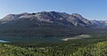
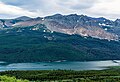
North aspect, from Two Medicine Road
Highest point
Elevation 7,522 ft (2,293 m) [1]
Prominence 122 ft (37 m) [1]
Parent peak Mount Henry (8,852 ft) [2]
Isolation 1.92 mi (3.09 km) [2]
Coordinates 48°29′05″N113°19′20″W / 48.48476945°N 113.32216469°W / 48.48476945; -113.32216469 [3]
Geography
USA Montana relief location map.jpg
Red triangle with thick white border.svg
Scenic Point
Location in Montana
Usa edcp relief location map.png
Red triangle with thick white border.svg
Scenic Point
Location in the United States
Location Glacier National Park
Glacier County, Montana, U.S.
Parent range Lewis Range
Rocky Mountains
Topo map USGS Dancing Lady Mountain
Climbing
Easiest route hiking trail

Scenic Point is a 7,522-foot-elevation (2,293-meter) mountain summit located in the Two Medicine area of Glacier National Park, in Glacier County, Montana, United States. [3] It is situated in the Lewis Range, six miles northwest of East Glacier Park Village, and approximately seven miles east of the Continental Divide, with precipitation runoff from the mountain draining into the Two Medicine River watershed. Topographic relief is significant as the north aspect rises over 2,600 feet (790 meters) above Lower Two Medicine Lake in one mile. Access to the summit is via the Continental Divide National Scenic Trail which traverses the upper slopes of this mountain. The trail to Scenic Point was constructed by the Great Northern Railway, and the summit once hosted a locomotive bell, a Swiss Alps tradition. [4] The mountain's name was officially adopted in 1929 by the United States Board on Geographic Names. [3]

Contents

Geology

The mountains in Glacier National Park are composed of sedimentary rock laid down during the Precambrian to Jurassic periods. Formed in shallow seas, this sedimentary rock was initially uplifted beginning 170 million years ago when the Lewis Overthrust fault pushed an enormous slab of precambrian rocks 3 mi (4.8 km) thick, 50 miles (80 km) wide and 160 miles (260 km) long over younger rock of the cretaceous period. [5]

Climate

According to the Köppen climate classification system, Scenic Point is located in an alpine subarctic climate zone with long, cold, snowy winters, and cool to warm summers. [6] Winter temperatures can drop below −10 °F with wind chill factors below −30 °F. Due to its altitude, it receives precipitation all year, as snow in winter, and as thunderstorms in summer.

See also

References

  1. 1 2 "Scenic Point, Montana". Peakbagger.com. Retrieved September 29, 2021.
  2. 1 2 "Scenic Point - 7,522' MT". listsofjohn.com. Retrieved September 29, 2021.
  3. 1 2 3 "Scenic Point". Geographic Names Information System . United States Geological Survey, United States Department of the Interior . Retrieved September 29, 2021.
  4. Aaron Theisen, Day Hiking: Glacier National Park & Western Montana, 2018, Mountaineers Books, ISBN   9781680510492
  5. Gadd, Ben (2008). "Geology of the Rocky Mountains and Columbias".{{cite journal}}: Cite journal requires |journal= (help)
  6. Peel, M. C.; Finlayson, B. L.; McMahon, T. A. (2007). "Updated world map of the Köppen−Geiger climate classification". Hydrol. Earth Syst. Sci. 11 (5): 1633. Bibcode:2007HESS...11.1633P. doi: 10.5194/hess-11-1633-2007 . ISSN   1027-5606. S2CID   9654551.