
This is a list of properties and districts in Massachusetts listed on the National Register of Historic Places. There are over 4,300 listings in the state, representing about 5% of all NRHP listings nationwide and the second-most of any U.S. state, behind only New York. Listings appear in all 14 Massachusetts counties.

This is a list of the National Register of Historic Places listings in Barnstable County, Massachusetts.

This is intended to be a complete list of properties and districts listed on the National Register of Historic Places in Orleans County, New York. The locations of National Register properties and districts may be seen in a map by clicking on "Map of all coordinates". Two listings, the New York State Barge Canal and the Cobblestone Historic District, are further designated a National Historic Landmark.

The Adams-Crocker-Fish House is an historic house in Barnstable, Massachusetts. Built about 1830, this half-Cape is a rare surviving example of a small farmstead with period outbuildings. The property was listed on the National Register of Historic Places in 1987.

The Atwood–Higgins Historic District encompasses a historic property with deep colonial roots in Cape Cod National Seashore. Located on Bound Brook Island on the west side of Wellfleet, Massachusetts, the centerpiece of the district is the Thomas Atwood House, built c. 1730. The property is emblematic of Cape Cod's colonial origins and its later transformation into a summer resort area. The house was listed on the National Register of Historic Places in 1976; the district was listed in 2010. The property is open for guided tours by the National Park Service on a seasonal basis.

The Thomas Bray Farm is a historic farmstead in Yarmouth, Massachusetts. It includes a house that is one of the oldest houses in Yarmouth, as well as a number of early 20th century outbuildings, located on about 10 acres (4.0 ha) of land adjoining Mill Pond in central Yarmouth. The house construction date has been estimated to be c. 1720, but it is possibly even older. It is an early example of a "half cape", a single story house with one room behind the other, and a chimney between. In a departure from typical plans, the chimney in this house is closer to the center of the roofline, rather than being in the bay behind the front door, which is in the rightmost of three bays.

The Capt. William Hallett House is a historic house in the Hyannis village of Barnstable, Massachusetts, USA.

The Wianno Historic District is a historic district in the Osterville section of Barnstable, Massachusetts. It encompasses a well-preserved summer resort area for the wealthy that was first developed in the late 19th century, focused around the Wianno Club, built in 1881 on the site of an earlier resort hotel. The 40-acre (16 ha) district has a significant number of well-preserved Shingle style and Colonial Revival houses. Architect Horace Frazer designed the Wianno Club, as well as a number of the private residences in the district. The district is roughly bounded by East Bay Road, Wianno and Sea View Avenues between Nantucket Sound and Crystal Lake. It was added to the National Register of Historic Places in 1987.
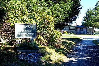
The Collins Cottages Historic District is a historic district encompassing a summer cottage resort in southern Eastham, Massachusetts. It consists of a group of small cottages built by Lewis and Bernard Collins in 1928–29 on a parcel of land on the shore of Town Cove, and were typical of a type of accommodation offered to tourists of the time. The property is located northeast of the Orleans rotary, and is accessed via a section of the old state highway. The cottages continue to be operated as summer accommodations by members of the Collins family.

The Crowell–Bourne Farm is a historic 1775 farmhouse on West Falmouth Highway in West Falmouth, Massachusetts.
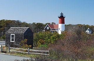
The French Cable Hut is a historic building in Cape Cod National Seashore, near the Nauset Beach Light in Eastham, Massachusetts. Built in 1891, the hut formed a linkage point in the transatlantic telegraph cable of the French Cable Company connecting the cable, where it came ashore near the present site to its main station in Orleans. After the cable was abandoned in 1932, the hut was adapted for residential use. It has since been restored to its turn-of-the-century appearance by the National Park Service. The building was listed on the National Register of Historic Places in 1976.

The French Cable Station is a historic telegraph station on the southeast corner of Cove Road and MA 28 in Orleans, Massachusetts.

The Jenkins–Whelden Farmstead is a historic farmstead in Barnstable, Massachusetts. It is one of Barnstable's best-preserved farm properties. The farm complex includes a c. 1840 house, an older 18th century house that is used as a toolshed, two barns, and several other small outbuildings. The current main house is a three-bay 1+1⁄2-story Cape cottage with Federal styling. The toolshed is believed to have been built by Thomas Jenkins (1666-1745), and was part of a larger house which was originally located on Church Street.

The Merrill Estate is a historic estate in the Marstons Mills section of Barnstable, Massachusetts. The estate house started as a 1+1⁄2-story Cape style house, with five bays and a large central chimney, built c. 1750–1775. This Georgian structure was extended in the middle of the 19th century with a 1+1⁄2-story Greek Revival ell that was added to the front of the house. The property includes an old English barn.

The Old King's Highway Historic District encompasses what was historically the principal east–west thoroughfare through Barnstable, Massachusetts. It encompasses Barnstable's entire length of what is now designated Massachusetts Route 6A and called Main Street, between the town lines of Sandwich and Yarmouth. It includes more than 1,000 acres (400 ha), and includes all of the buildings whose properties front on the road, nearly 500 in all. The area includes the main population centers of Barnstable from its founding in the late 1630s until the mid-19th century, when the southern parts of the community became more significant in economic prominence. The district was listed on the National Register of Historic Places in 1987.

The Matthias Smith House is a historic house at 375 Cedar Street in Barnstable, Massachusetts. The 1+1⁄2-story Cape style wood-frame house was built c. 1760 by Matthias Smith, and was the center of a working farm for two centuries. It is five bays wide, with a central entry and central chimney, with two single-story ells added to its left. The entry is topped by a small transom window with two bullseye lights. The house is a well-preserved example of a mid-18th century farmhouse; the property includes a number of agricultural outbuildings, including a barn, toolshed, and chicken houses.

This is a list of the National Register of Historic Places listings in Kandiyohi County, Minnesota. It is intended to be a complete list of the properties and districts on the National Register of Historic Places in Kandiyohi County, Minnesota, United States. The locations of National Register properties and districts for which the latitude and longitude coordinates are included below, may be seen in an online map.
This is a list of the National Register of Historic Places listings in Cape Cod National Seashore.

The Barnstable Fair Hall or Barnstable Agricultural Hall was an exhibition hall located in Barnstable, Massachusetts that was listed on the National Register of Historic Places on March 7, 1979. It was leveled by fire in the early morning of April 2, 1980. In the early 1990s, the structure was re-built as a condominium complex. In 1856 and 1857, land around the present building was given and sold to the Agricultural Society for use as a fairground. Total acreage of the property eventually exceeded twenty acres and extended as far back as the Maraspin Creek, a tidal stream. In 1857- 1858 a building "for exhibition purposes and a hall for public meetings" was built on the site of the present building. In February 1862, this first fair hall was destroyed by a gale, resulting in the formation of a building committee in April 1862 and the construction of the new structure between June 17 and October 14, 1862. Money for building costs came from private subscription, to which William Sturgis, a Boston merchant and native of Barnstable, was the major donor. Praised as being "superior in taste to the old" hall, the new Fair Hall was dedicated at the Barnstable County Fair of 1862 and served as the exhibition hall for all subsequent annual fairs until 1931 when the fair ceased to be held regularly. The fair is now held on an annual basis in Falmouth. During the period in which this property served as a fairground, there were additional shed and storage buildings to the north and east of the Fair Hall, as well as a track for trotting races, baseball diamond and grandstand, all of which have been removed. In addition to the usual exhibits of livestock and agricultural products, turn-of-the century fairs had vaudeville performances, balloonists, and other entertainments.

Barnstable, Massachusetts, has more than 75 entries on the National Register of Historic Places. For listings elsewhere in Barnstable County, see National Register of Historic Places listings in Barnstable County, Massachusetts.


