
Massachusetts Avenue is a major diagonal transverse road in Washington, D.C., and the Massachusetts Avenue Historic District is a historic district that includes part of it.

The Provincetown Historic District encompasses most of the dense urban center of Provincetown, Massachusetts. The district is roughly bounded to the north by U.S. Route 6; to the west by the west end of Commercial St.; to the south by Provincetown Harbor; and to the east by the southeast end of Commercial St. It covers about 300 acres (120 ha), and includes more than 1,000 buildings. Its historic character spans more than 200 years of settlement, from the city's early years as a fishing community, to its development as a summer resort area and artists' colony beginning in the late 19th century. The district was listed in the National Register of Historic Places in 1989. Four properties in the district are also individually listed.

The East Blackstone Village Historic District is a historic district roughly along Elm Street at the junction with Summer Street in eastern Blackstone, Massachusetts. It encompasses a small 19th-century mill village center that developed along what was once a major roadway connecting Worcester with Providence, Rhode Island. The district was added to the National Register of Historic Places in 1995.

The Hotchkissville Historic District is a historic district in the town of Woodbury, Connecticut, United States that was listed on the National Register of Historic Places in 1995. The district encompasses most of the historic village of Hotchkissville, which is centered at the junction of Washington and Weekeepeemee roads. The village began as a dispersed rural agricultural community, but developed in the 19th century with the arrival of industry, primarily the manufacture of textiles. Despite this, the village has retained a significantly rural character, and includes a broad cross-section of 18th- and 19th-century architectural styles.

The Lower Highlands Historic District encompasses one of the oldest residential areas of Fall River, Massachusetts. The district is roughly bounded by Cherry, Main, Winter, and Bank Streets, and is located just east of the Downtown Fall River Historic District and directly south of the Highlands Historic District. This area was settled by 1810, has architecture tracing the city's growth as a major industrial center. The historic district was added to the National Register of Historic Places in 1984.
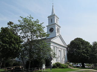
The Centerville Historic District is a historic district encompassing the heart of the village of Centerville in Barnstable, Massachusetts. The district extends along Main Street from a point north of its junction with Old Stage Road and Park Avenue, south to the junction with Church Hill Road. Most of the buildings in the district were built in the middle decades of the 19th century, although its oldest building, the Austin Bearse House, was built c. 1690. The area's growth was spurred by the relocation in 1826 of the Congregational Church building to its present location. The district was listed on the National Register of Historic Places in 1987.

The Cotuit Historic District is a historic district encompassing the heart of the village of Cotuit in Barnstable, Massachusetts. It extends along Main Street from Lowell Street in the north to Sea Street in the south, and includes portions of Ocean View Avenue and properties on adjacent roads. The oldest properties date to the late 18th century, but saw its greatest development during the height of the area's maritime industry in the mid 19th century. In the late 19th and early 20th century the area saw new development as a summer resort area. The district was listed on the National Register of Historic Places in 1987.

The Parsons, Shepherd, and Damon Houses Historic District is a historic district on the east side of downtown Northampton, Massachusetts encompassing a 2.5-acre (1.0 ha) property that was first laid out in 1654. Now owned by Historic Northampton, the property includes three houses built between 1730 and 1830. The district was added to the National Register of Historic Places in 2001.

The Bridge Street Neck Historic District is a predominantly residential historic district in Salem, Massachusetts. It encompasses most of a peninsula of land northeast of downtown Salem, on the route connecting Salem to Beverly, which has been the scene of residential, commercial, and industrial development since the early settlement of Salem in the 1630s. Bridge Street, the spine of the district is a thoroughfare connecting Salem to the bridge leading to Beverly. The district is roughly bounded by railroad tracks to its west, the shore of the peninsula to the east, On the north it is bounded by modern (post-1952) developments, and on the south it abuts the Salem Common Historic District. In addition to properties on Bridge Street, the district includes properties on side streets between March/Osgood Streets, and Howard/Webb Streets. It was listed on the National Register of Historic Places in 2002.

The East End Historic District encompasses the historic eastern portion of central Ipswich, Massachusetts. The now predominantly residential district is bounded on the north and west by East Street, running from its junction with North Main and High Streets to Jeffrey's Neck Road. The eastern boundary includes the Ipswich River and Turkey Shore Road from its junction with Labor-in-Vain Road to Green Street, and the southern boundary runs along Green Street to North Main. The district was listed on the National Register of Historic Places in 1980.

The High Street Historic District is a predominantly residential historic district in Ipswich, Massachusetts. It encompasses the oldest section of High Street, which was laid out when Ipswich was founded in 1633. The district runs for four blocks from the junction with Town Farm Road and the railroad right-of-way in the west, to North Main Street in the east. The street was for several centuries part of the principal thoroughfare through the town, but became sidelined by the construction of Central Street in 1871, which bypassed traffic off most of this stretch of High Street.

The North Canal Historic District of Lawrence, Massachusetts, encompasses the historic industrial heart of the city. It is centered on the North Canal and the Great Stone Dam, which provided the waterpower for its many mill complexes. The canal was listed on the National Register of Historic Places in 1975, while the district was first listed in 1984, and then expanded slightly in 2009.
The Silver Hill Historic District encompasses the first major residential subdivision of Weston, Massachusetts. It includes 79 buildings on Silver Hill and Westland Roads, and Merriam Street. The area of Silver Hill and Westland Roads was formally laid out in 1905, while Merriam Street is a very old country road which had seen some development in the 1890s. The houses in the district are predominantly Colonial Revival and Queen Anne in their styling, a relative rarity in Weston although common in other Boston suburbs. The district was added to the National Register of Historic Places in 2004.

The Church–Lafayette Streets Historic District encompasses a well-preserved collection of late 18th- and early 19th-century houses in Wakefield, Massachusetts. It includes properties on Church Street between Common Street and North Avenue, and on Lafayette Street between Common and Church Streets. The district was added to the National Register of Historic Places in 1989.

The Taftsville Historic District encompasses a historic 19th-century industrial village that is mostly in Woodstock, Vermont. Flanking the Ottauquechee River and extending up Happy Valley Road, the area developed around a metal tool factory established by members of the Taft family in 1793. Important elements from its early history include the Taftsville Store, built by the Taft family in 1840, and the Taftsville Covered Bridge, built in 1836. The district was listed on the National Register of Historic Places in 2001.

There are 76 properties listed on the National Register of Historic Places in Albany, New York, United States. Six are additionally designated as National Historic Landmarks (NHLs), the most of any city in the state after New York City. Another 14 are historic districts, for which 20 of the listings are also contributing properties. Two properties, both buildings, that had been listed in the past but have since been demolished have been delisted; one building that is also no longer extant remains listed.

The Head of the River Historic District is a historic district encompassing a village area at the head of navigation of the Acushnet River, which separates Acushnet and New Bedford, Massachusetts. The village is centered at the junction of Tarkin Hill Road, River Road, and Mill Road in New Bedford, and Main Street in Acushnet. The area went through two significant periods of development: the first was in the late 18th and early 19th century, and the second was in the early 20th century. The district was listed on the National Register of Historic Places in 2009.

The Charlestown Main Street Historic District encompasses the historic heart of Charlestown, New Hampshire. It is located along Main Street, roughly between Lower Landing Road and Bridge Street, and encapsulates more than two hundred years of the town's history. The district was listed on the National Register of Historic Places in 1987.

The Exeter Waterfront Commercial Historic District encompasses the historic commercial and residential waterfront areas of Exeter, New Hampshire. The district extends along the north side of Water Street, roughly from Main Street to Front Street, and then along both sides of Water and High streets to the latter's junction with Portsmouth Street. It also includes properties on Chestnut Street on the north side of the Squamscott River. This area was where the early settlement of Exeter took place in 1638, and soon developed as a shipbuilding center. The district was listed on the National Register of Historic Places in 1980. It was enlarged in 1986 to include the mill complex of the Exeter Manufacturing Company on Chestnut Street.

The Town Center Historic District encompasses the historic village center of South Hampton, New Hampshire. Centered around the Barnard Green, the town common, on New Hampshire Route 107A, it includes architectural reminders of the town's growth and change over time. The district was listed on the National Register of Historic Places in 1983.


