
Phillipston is a town in Worcester County, Massachusetts, United States. The population was 1,724 at the 2020 census.

Winchester National Cemetery is a United States National Cemetery located in the city of Winchester in Frederick County, Virginia. Administered by the United States Department of Veterans Affairs, it encompasses 4.9 acres (2.0 ha), and as of the end of 2005, it had 5,561 interments. It is closed to new interments.

Wright Cemetery is a historic cemetery on Groton Road near Lynwood Lane in Westford, Massachusetts. The cemetery was formally established in 1836 as a private cemetery for the locally numerous Wright family, although its earliest documented burial dates to 1819. Maintenance and operation of the cemetery was taken over by the town in 1909. The half-acre plot has approximately 150 marked grave sites, and remains in use. The cemetery was added to the National Register of Historic Places in 2005.

Hillside Cemetery, also known as the North Burying Ground, is a historic cemetery on Depot and Nutting Roads in Westford, Massachusetts. The cemetery was established in 1753, and is the burial site of a number of people important in local history. It contains approximately 300 burials, and continues in active use. The cemetery was listed on the National Register of Historic Places in 2005.

The Mechanic Street Cemetery is a historic early cemetery on Mechanic Street in Westfield, Massachusetts. The 4-acre (1.6 ha) cemetery is the city's oldest, with the oldest documented grave dating to 1683. It was used as a burying ground until the late 19th century, although its use began to decline in the middle of the century, with the advent of the popular rural cemetery movement, which was reflected in Westfield with the establishment of the new Pine Hill Cemetery in 1842. No burials were recorded in the 20th century. Although the cemetery has been subjected to some maintenance work, it continues to suffer the effects of vandalism and weather. The cemetery was listed on the National Register of Historic Places in 2002.

Center Cemetery is a historic cemetery on the south side of Sam Hill Road in Worthington, Massachusetts. The 2.4-acre (0.97 ha) cemetery was established c. 1774, and continues to be used today. Its burials include many of the founders and early settlers of Worthington, and of families influential in the growth and development of the town. The cemetery listed on the National Register of Historic Places in 2004.

Prospect Hill Cemetery is a historic cemetery on Auburn Road in Millis, Massachusetts. Founded in 1714, it is the town's only cemetery. Covering more than 18 acres (7.3 ha), it has more than 2,800 burials. Among those buried in the cemetery are politician Christian Herter, who served as U.S. Secretary of State and Governor of Massachusetts, and two Medal of Honor recipients, Charles Church Roberts and William D. Newland. The cemetery was listed on the National Register of Historic Places in 2006 with the help of a short documentary film by a Millis High School Freshman Dustin Fresh.

North Cemetery is a historic cemetery in Worthington, Massachusetts. The 3.5-acre (1.4 ha) municipal cemetery is located at the corner of Cold and North Streets not far from Worthington Corners; it is the town's largest cemetery. The cemetery was listed on the National Register of Historic Places in 2004, for its funerary architecture and its role as the burial ground for the town's early settlers.

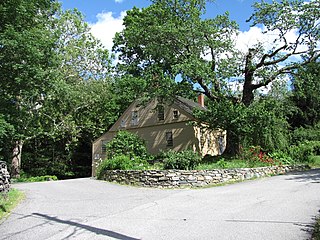
Phillipston Center Historic District encompasses the historic village center of Phillipston, Massachusetts. The town was first settled in 1751 on land grants made in the 1730s, and was incorporated as a separate town in the 1770s. The surviving village center not far from the location of the first settlement, eventually came to include a tavern. After incorporation, the center developed around what is now the junction of the Baldwinville, Petersham, and Templeton Roads, although this took time, possibly because of difficulties associated with the American Revolutionary War. As a result, the district has relatively few properties that date to the 18th century. All of these are modest vernacular residential structures. The town grew only modestly until 1830, after which time its population declined, not reaching the same level until 1980, 150 years later. As a result of the lack of growth, most of the properties in the district are Federal and Greek Revival in character. Many of the institutional buildings in the center date to the late 19th and early 20th centuries. The district was added to the National Register of Historic Places in 1999.
The Freegrace Marble Farm Historic District encompasses a historic farmstead in Sutton, Massachusetts. Although most of its buildings date to the 19th century, the farm has retained the form of a typical 18th-century farm, including a substantial portion of the land granted in 1717 to Freegrace Marble, one of Sutton's earliest colonial settlers. The property was listed on the National Register of Historic Places in 1989.
The Lawrence Street Cemetery, or more commonly known as "the Village Burying Ground", is a historic cemetery on Lawrence Street in Methuen, Massachusetts.

The Hill Cemetery and Parson Hubbard House Historic District encompasses a historic cemetery and parsonage in Shelburne, Massachusetts. The two properties are located on Old Village Road, on a hill above the Deerfield River known as Old Village Hill, and are the oldest surviving elements of the town's early colonial settlement. The district was listed on the National Register of Historic Places in 2006.

Ringville Cemetery is a historic cemetery on Witt Hill Road in the hamlet of Ringville, part of Worthington, Massachusetts. The roughly 3-acre (1.2 ha) cemetery was established in 1866, when the town purchased 0.75 acres (0.30 ha) from Ethan Ring. The cemetery was quickly expanded over the next twenty years, reaching a size of 2 acres (0.81 ha). In the 1970s the town purchased an additional acre, giving the cemetery its present size. Ringville, the village in which it lies, was in the 19th century the industrial heart of Worthington, supporting a number of mills.

Gilead Cemetery is located in the town of Carmel, New York, United States. It is off a bend in Mechanic Street 1.5 miles (2.4 km) south of the hamlet of Carmel, seat of Putnam County.

Daddy Frye's Hill Cemetery is a historic cemetery at East and Arlington Streets in Methuen, Massachusetts. Established in 1728, it is the city's oldest cemetery, and the only major surviving element of its original town center. It was listed on the National Register of Historic Places in 1984. The area is also locally known as Meeting House Hill.

Blue Hills Parkway is a historic parkway that runs in a straight line from a crossing of the Neponset River, at the south border of Boston to the north edge of the Blue Hills Reservation in Milton, Massachusetts. It was built in 1893 to a design by the noted landscape architect, Charles Eliot, who is perhaps best known for the esplanades along the Charles River. The parkway is a connecting road between the Blue Hills Reservation and the Neponset River Reservation, and was listed on the National Register of Historic Places in 2003.

Kent Burying Ground is a historic cemetery at the corner of Fayette Corner Road and Oak Hill Road in Fayette, Maine. Established in 1880 by Elias Kent, it is unusual for its layout of concentric rings around a central monument, only known in one other cemetery in the state, the Wing Family Cemetery in nearby Wayne. The cemetery was listed on the National Register of Historic Places in 2008.

Gate Cemetery is a historic cemetery on Ireland Street in West Chesterfield, Massachusetts. It is located just under one mile (1.6 km) south of the center of West Chesterfield, the junction of Main Road and Ireland Street. The 1/3 acre cemetery is on a plateau of land on the east side of Ireland Street, flanked to the east by the Westfield River and to the west by a steep hillside. It takes its name from a toll gate that was erected nearby when the area was settled in the late 18th century.

The Ireland Street Cemetery is a historic cemetery on Ireland Street in West Chesterfield, Massachusetts. The cemetery contains 185 stones, dating from 1772 to 1996, most of which date to the 18th and 19th centuries. It is one of the town's oldest cemeteries, and contains the work of three significant funerary carvers of the late 18th and 19th centuries. The cemetery was listed on the National Register of Historic Places in 2009.
The Bradford Burial Ground is a historic cemetery at 326 Salem Street in the Bradford section of Haverhill, Massachusetts. The 1.5-acre (0.61 ha) cemetery was established in 1665, on land given by John Heseltine to the town of Bradford. The oldest readable marker in the cemetery has a date of 1689, but there are likely to be older burials. The cemetery was listed on the National Register of Historic Places in 2015.


