
Dillingham, also known as Curyung, is a city in Dillingham Census Area, Alaska, United States. Incorporated in 1963, it is an important commercial fishing port on Nushagak Bay. As of the 2020 census, the population of the city was 2,249, down from 2,329 in 2010.

The Pacific geoduck is a species of very large saltwater clam in the family Hiatellidae. The common name is derived from the Lushootseed name, gʷidəq.

Bodega Bay is a shallow, rocky inlet of the Pacific Ocean on the coast of northern California in the United States. It is approximately 5 mi (8 km) across and is located approximately 40 mi (60 km) northwest of San Francisco and 20 mi (32 km) west of Santa Rosa. The bay straddles the boundary between Sonoma County to the north and Marin County to the south. The bay is a marine habitat used for navigation, recreation, and commercial and sport fishing.

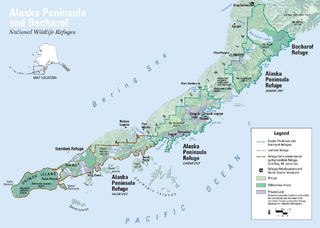
The Alaska Peninsula National Wildlife Refuge is a United States National Wildlife Refuge in southwestern Alaska whose use is regulated as an ecological-protection measure. It stretches along the southern coast of the Alaska Peninsula, between the Becharof National Wildlife Refuge on its east and the end of the peninsula at False Pass in the west. In between, however, it is broken into sections by lands of the Aniakchak National Monument and Izembek National Wildlife Refuge. The refuge is administered from offices in King Salmon, Alaska and was established to conserve Alaska Peninsula brown bears, caribou, moose, marine mammals, shorebirds, other migratory birds and fish, and to comply with treaty obligations.

Glacier Bay National Park and Preserve is an American national park located in Southeast Alaska west of Juneau. President Calvin Coolidge proclaimed the area around Glacier Bay a national monument under the Antiquities Act on February 26, 1925. Subsequent to an expansion of the monument by President Jimmy Carter in 1978, the Alaska National Interest Lands Conservation Act (ANILCA) enlarged the national monument by 523,000 acres on December 2, 1980, and created Glacier Bay National Park and Preserve. The national preserve encompasses 58,406 acres of public land to the immediate northwest of the park, protecting a portion of the Alsek River with its fish and wildlife habitats, while allowing sport hunting.
Kachemak Bay is a 40-mi-long (64 km) arm of Cook Inlet in the U.S. state of Alaska, located on the southwest side of the Kenai Peninsula. The communities of Homer, Halibut Cove, Seldovia, Nanwalek, Port Graham, and Kachemak City are on the bay as well as three Old Believer settlements in the Fox River area, Voznesenka, Kachemak Selo, and Razdolna.
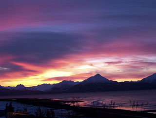
The Alaska Peninsula is a peninsula extending about 497 mi (800 km) to the southwest from the mainland of Alaska and ending in the Aleutian Islands. The peninsula separates the Pacific Ocean from Bristol Bay, an arm of the Bering Sea.

Resurrection Bay, also known as Blying Sound, and Harding Gateway in its outer reaches, is a fjord on the Kenai Peninsula of Alaska, United States. Its main settlement is Seward, located at the head of the bay. The bay received its name from Alexandr Baranov, who was forced to retreat into the bay during a bad storm in the Gulf of Alaska. When the storm settled it was Easter Sunday, so the bay and nearby Resurrection River were named in honor of it. Harding Gateway refers to the passage between Rugged and Cheval Islands.

Southwest Alaska is a region of the U.S. state of Alaska. The area is not exactly defined by any governmental administrative region(s); nor does it always have a clear geographic boundary.
The Ottawa Islands are a group of currently uninhabited islands situated in the eastern edge of Canada's Hudson Bay. The group comprises 24 small islands, located at approximately 60N 80W. The main islands include Booth Island, Bronson Island, Eddy Island, Gilmour Island, J. Gordon Island, Pattee Island, and Perley Island. The highest point is on Gilmour Island, which rises to over 1,800 ft (550 m). Located a short distance off the northwest coast of Quebec's Ungava Peninsula, they, like the other coastal islands in Hudson Bay, were historically part of the Northwest Territories, and became Crown Land upon the creation of Nunavut in 1999. Nunavik Inuit have occupied these islands since time immemorial and gained constitutionally-protected harvest and access rights under the Nunavik Inuit Land Claim Agreement signed in 2007.
The Dungeness National Wildlife Refuge is located near the town of Sequim in Clallam County in the U.S. state of Washington, on the Strait of Juan de Fuca. The refuge is composed of 772.52 acres (312.63 ha) which include Dungeness Spit, Graveyard Spit, and portions of Dungeness Bay and Harbor. Dungeness Spit is one of the world's longest natural sand spits, 6.8 miles (10.9 km) long and very narrow. A lighthouse, the New Dungeness Light, built in 1857, is located near the end of the spit. Access to Dungeness Spit is through a Clallam County Park which has hiking trails, picnic areas, and a campground. On January 20, 1915, it was designated as a National Wildlife Refuge by President Woodrow Wilson. Dungeness is one of six refuges in the Washington Maritime National Wildlife Refuge Complex.

According to the California Protected Areas Database (CPAD), in the state of California, United States, there are over 14,000 inventoried protected areas administered by public agencies and non-profits. In addition, there are private conservation areas and other easements. They include almost one-third of California's scenic coastline, including coastal wetlands, estuaries, beaches, and dune systems. The California State Parks system alone has 270 units and covers 1.3 million acres (5,300 km2), with over 280 miles (450 km) of coastline, 625 miles (1,006 km) of lake and river frontage, nearly 18,000 campsites, and 3,000 miles (5,000 km) of hiking, biking, and equestrian trails.
The Susitna Flats State Game Refuge is a game preserve in the U.S. state of Alaska. Each year approximately 10 percent of the waterfowl harvest in the state of Alaska occurs on Susitna Flats, with about 15,000 ducks and over 500 geese taken. Many hunters land float planes on one of the numerous lakes on the flats. Other hunters cross the inlet by boat to enjoy their hunt.
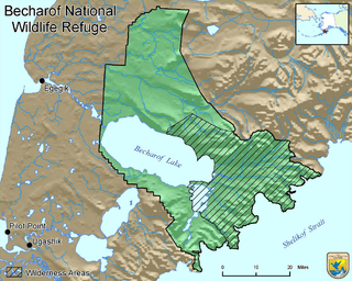
Becharof National Wildlife Refuge is a National Wildlife Refuge in the Aleutian Range of the Alaska Peninsula of southwestern Alaska. It is adjacent to Katmai National Park and Preserve. This national wildlife refuge, which covers an area of 1,200,000 acres (4,900 km2), was established in 1980 to conserve major brown bears, salmon, migratory birds, caribou, marine birds, and mammals and to comply with treaty obligations. It lies primarily in the east-central part of Lake and Peninsula Borough, but extends eastward into the mainland portion of Kodiak Island Borough. The refuge is administered from offices in King Salmon.

Morro Bay State Marine Recreational Management Area (SMRMA) and Morro Bay State Marine Reserve (SMR) are two marine protected areas that provide protection for Morro Bay Estuary on California's central coast. The two marine protected areas together encompass 3.31 square miles (8.6 km2). The SMR protects all marine life within its boundaries. Fishing and take of any living marine resources is prohibited. nWithin the SMRMA, fishing or taking any living marine resources is prohibited with the exception that, with a valid state water bottom lease and permit, the recreational taking of finfish and the aquaculture of oysters is permitted north of latitude 35° 19.70′ N. Recreational hunting of waterfowl is allowed unless otherwise restricted by hunting regulations.

Yup'ik cuisine refers to the Eskimo style traditional subsistence food and cuisine of the Yup'ik people from the western and southwestern Alaska. Also known as Cup'ik cuisine for the Chevak Cup'ik dialect speaking Eskimos of Chevak and Cup'ig cuisine for the Nunivak Cup'ig dialect speaking Eskimos of Nunivak Island. This cuisine is traditionally based on meat from fish, birds, sea and land mammals, and normally contains high levels of protein. Subsistence foods are generally considered by many to be nutritionally superior superfoods. Yup’ik diet is different from Alaskan Inupiat, Canadian Inuit, and Greenlandic diets. Fish as food are primary food for Yup'ik Eskimos. Both food and fish called neqa in Yup'ik. Food preparation techniques are fermentation and cooking, also uncooked raw. Cooking methods are baking, roasting, barbecuing, frying, smoking, boiling, and steaming. Food preservation methods are mostly drying and less often frozen. Dried fish is usually eaten with seal oil. The ulu or fan-shaped knife is used for cutting up fish, meat, food, and such.
Bettles Bay State Marine Park is a 679-acre undeveloped Alaska state marine park. There is no road access to the park. The park can be accessed from the lagoon northeast of the islands. The park offers great views of Bettles Glacier. Attractions include an old stamp press and gold mine, just southeast of the park.
Boswell Bay State Marine Park is a 3,047 acre undeveloped Alaska state marine park on the eastern tip of Hinchinbrook Island, approximately 15 miles southwest of Cordova. Areas of the park are adjacent to the Copper River Delta State Critical Habitat. In 1964, an earthquake uplifted a substantial part of the park, moving the shore inland by more than a mile.
Shoup Bay is an inlet of Port Valdez inside the Valdez Arm of Prince William Sound in Alaska. steep-walled, flat-bottomed basin with a depth of approximately 200 ft. described as a hanging valley that formed during more extensive Pleistocene glaciation. Located eight miles west of Valdez, Alaska, United States, it is fed by Shoup Glacier, as well as McCallister Creek, Palmer Creek, and Uno Creek. The bay itself opens into the Valdez Narrows and is included as part of the Shoup Bay State Marine Park.
