
Botswana, officially the Republic of Botswana, is a landlocked country in Southern Africa. Botswana is topographically flat, with up to 70 percent of its territory being the Kalahari Desert. It is bordered by South Africa to the south and southeast, Namibia to the west and north, and Zimbabwe to the northeast. It is connected to Zambia across the short Zambezi River border by the Kazungula Bridge.
Transportation in Botswana is provided by internal and extensive network of railways, highways, ferry services and air routes that criss-cross the country.

Gaborone is the capital and largest city of Botswana with a population of 231,626 based on the 2011 census, about 10% of the total population of Botswana. Its agglomeration is home to 421,907 inhabitants at the 2011 census.
Mochudi is one of the larger villages in Botswana with a population of 44,815 people in 2011. It is situated in the Bakgatla tribal region, in Kgatleng District, about 37 km (23 mi) northeast of Gaborone. The village lies several kilometres from the main Gaborone–Francistown road, and can be accessed through a short turn at Pilane. Mochudi was settled by the Tswana people in 1871. The main attraction in Mochudi is the Phuthadikobo Museum which is perched at the top of a hill and holds a rich history of Bakgatla tribe and Batswana in general

Ghanzi is a district in western Botswana, bordering Namibia in the west and extending east into much of the interior of the country. The district's administrative centre is the town of Ghanzi. Most of the eastern half of Ghanzi makes up the Central Kalahari Game Reserve. The human population at the 2001 census was 43,370, less populous than that of any other district in Botswana. Ghanzi's area is 117,910 km².
Barolong is a tribe of Tswana people from Botswana and South Africa. Their King, Tau was the descendant of King Morolong who is the founder of Barolong tribe. He reigned around 1240 and adopted Tholo as the Barolong totem. King Tau was a warrior king who reigned around 1660. He fought many battles and consolidated the Barolong tribe to become a very strong kingdom. He had many wives and begot many sons and daughters. The prominent four sons are Ratlou, Tshidi, Seleka and Rapulana. The Barolong tribe later used the names of the warrior King Tau's sons as their clan names. The Barolong tribe spread across the regions covering Botswana, through to Transvaal, Northern Cape and Free State. Its important to note that King Tau’s heir to the throne was Ratlou. After the death of King Tau in Taung, to which Taung is named after, Barolong left Taung under Nthua, the younger brother of Tau. They settled in Dithakwaneng, and later, Dithakong, where Nthua died and was buried. Ratlou and the tribe left Dithakong for Mamusa, and later settled in their former capital I.e. Setlagole. This is the place where the kingship of Barolong disintegrated into a number of clans, after Tau's sons. This is after the death of Ratlou. He (Ratlou) had four sons i.e. Mariba, Seitshiro, Mokalake and Moirwagale. Two of these sons fought for the throne, with Mokalake supporting Mariba while Moirwagale supported Seitshiro. Moirwagale became the Regent for Seitshiro while Mokalake became one for Mariba. Finally Barolong disintegrated into four clans, and later five. Their final settlements are as follows; Ratlou; Mariba (Ganyesa); Seitshiro (Khunwana); Tshidi and Makgetla-Mahikeng; Seleka-Thaba nchu; Rapulana-Bodibe.

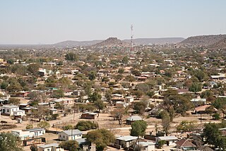
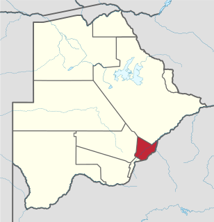
Southern is one of the districts of Botswana. The capital of Southern district is Kanye, home to the Bangwaketse and Barolong in Botswana. The Southern district is home to Botswana's second largest beef farmers where there are large privately owned ranges, and several government run beef ranges which provide agricultural support to the local farmers. Maize and sorghum, Botswana's staple crop, are also raised in the area. Southern district is where the third diamond mine of Botswana was found, which buoys Botswana's economic state of prosperity. It was the first district to house the capital city before being moved to Gaborone after independence.

Kweneng is one of the districts of Botswana and is the recent historical homeland of the Bakwena people, the first group in Botswana converted to Christianity by famed missionary David Livingstone. Various landmarks, including Livingstone's Cave, allude to this history. The seat of the district's government is Molepolole, Botswana's most populous village.

The North-West District or Ngamiland is one of the first-level administrative subdivisions of Botswana. For census and administrative purposes Ngamiland is subdivided into Ngamiland East, Ngamiland West and Ngamiland Delta (Okavango). It is governed by a District Commissioner, appointed by the national government, and the elected North-West District Council. The administrative centre is Maun.
Kgatleng is one of the districts of Botswana, coterminous with the homeland of the Bakgatla people. Its capital is Mochudi, the hometown of protagonist Precious Ramotswe in Alexander McCall Smith's popular The No. 1 Ladies' Detective Agency series. According to the 2001 Census, Kgatleng had a population of 73,507 people.

South-East is one of the districts of Botswana. The capital city of Botswana, Gaborone, is surrounded by this district. The administrative capital for the South-East district is the village of Ramotswa. In the southeast, South-East borders the North West Province of South Africa. Domestically, it borders Kgatleng in northeast, Kweneng in northwest, Southern in southwest.

Central is the largest of Botswana's districts in terms of area and population. It encompasses the traditional homeland of the Bamangwato people. Some of the most politically connected Batswana have come from the Central District, including former President Sir Seretse Khama, former President Festus Mogae, and former President Lt. General Seretse Ian Khama. The district borders the Botswanan districts of Chobe in the north, North-West in the northwest, Ghanzi in the west, Kweneng in southwest, Kgatleng in the south and North-East in the northeast, as well as Zimbabwe also in the northeast and South Africa in the southeast.

Kanye is a village in southern Botswana, located 83 kilometres (52 mi) south-west of the capital, Gaborone. It is the administrative centre of the Southern District, and had a population of 45,196 at the 2011 census, making it the eighth-largest village in the country. Kanye is the traditional capital of the Ngwaketse tribe, who first settled in the area in the 1790s. The town is the longest continuously occupied tribal capital in the country.
Lerala is a village in Central District of Botswana. The village is located at the south-eastern end of the Tswapong Hills, 30 km (19 mi) from the Limpopo River and the border with South Africa and approximately 90 km (56 mi) east of Palapye. The population of Lerala was 6,871 in the 2011 census, which was a 20.5% increase from the 2001 population.

Chobe District is an administrative district in the northern part of Botswana, with the headquarters in Kasane. In 2001 it was merged with Ngamiland, and until 2006 it shared with Ngamiland the North-West District Council as local government. Chobe National Park is in the Chobe District. As of 2011, the total population of the district was 23,347 compared to 18,258 in 2001. The growth rate of population during the decade was 2.49. The total number of workers constituted 12,059 with 6,113 males and 5,947 females, with majority of them working in public administration.
Lejwana, Botswana is a small village in the Republic of Botswana in Africa. It is situated in the Southern District of Botswana. It lies between the coordinates 25°24'23S and 25°32'27E. It is situated between the villages of Gathwane, Pitsane, Kgoro and Digawana. Lejwana is about 30 km from Lobatse and about 100 km by road from the capital Gaborone.
Mmadinare is a village that is located in the Central District of Botswana, 15 kilometers from Selibe Phikwe. The village is slowly growing into a town, with a population estimate of about 13 000 people of different tribes including Bangwato, Batalaote, Babirwa, and others. Mmadinare is located in the center of hills; like other villages in Southern Africa it was started during wars and hills were used as a form of protection from enemies, as they were able to see them from a distance.
Tsetsebjwe is a village in the Bobirwa sub-district of the Central District of Botswana. It is in the Central Bobonong census district. As of 2001 it had a population of 4,396. The village is northwest of the privately owned Limpopo-Lipadi Game and Wilderness Reserve, near the South African border.
Bobirwa Subdistrict is a jurisdiction in Botswana. It is populated by the Babirwa (Ba-Birwa) people who came from Transvaal in present-day South Africa.
Tumasera is a village located in the Central District of Botswana. It had 3,136 inhabitants at the 2011 census. The village name is derived from taking first two letters of four villages of Tupsa, Malete, Seleka, and Rasesa: Tu- for Tupsa, Ma- for Malete, Se- for Seleka, and Ra- for Rasesa, together making TuMaSeRa.
