Sentinel Peak (Adamant Range)

Last updated
Sentinel Peak
Sentinel Peak E.jpg
East aspect
Highest point
Elevation 2,992 m (9,816 ft) [1] [2]
Prominence 111 m (364 ft) [3]
Parent peak Adamant Mountain (3,345 m) [3]
Isolation 1.45 km (0.90 mi) [3]
Listing Mountains of British Columbia
Coordinates 51°44′44″N117°52′20″W / 51.74556°N 117.87222°W / 51.74556; -117.87222 [4]
Geography
Canada British Columbia relief location map.jpg
Red triangle with thick white border.svg
Sentinel Peak
Location of Sentinel Peak in British Columbia
Canada relief map 2.svg
Red triangle with thick white border.svg
Sentinel Peak
Sentinel Peak (Canada)
Country Canada
Province British Columbia
District Kootenay Land District [5]
Parent range Adamant Range [1]
Selkirk Mountains
Topo map NTS 82N12 Mount Sir Sandford [4]
Climbing
First ascent 1946 [1]
Easiest route Scrambling [6]

Sentinel Peak is a 2,992-metre (9,816-foot) mountain in British Columbia, Canada.

Contents

Description

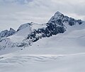
Sentinel Peak is part of the Adamant Range which is a subrange of the Selkirk Mountains. [5] It is located 80 km (50 mi) northwest of Golden and 30 km (19 mi) north of Glacier National Park. Sentinel Peak is highly glaciated with the Granite Glacier west of the peak, Echo Glacier in the north cirque, and the Gothics Glacier on the south and east slopes of the peak. Precipitation runoff and glacial meltwater from the mountain drains to Kinbasket Lake via Smith and Swan creeks. Topographic relief is significant as the summit rises 1,800 metres (5,905 ft) above Smith Creek in 5 km (3.1 mi) and 1,500 metres (4,921 ft) above Swan Creek in 4 km (2.5 mi). Sentinel Peak is located south of the Bill Putnam hut which makes the peak an excellent ski mountaineering destination. [6] The mountain's toponym was officially adopted on March 4, 1965, by the Geographical Names Board of Canada. [4]

Climate

Based on the Köppen climate classification, Sentinel Peak is located in a subarctic climate zone with cold, snowy winters, and mild summers. [7] Winter temperatures can drop below −20 °C with wind chill factors below −30 °C. This climate supports three glaciers on the slopes of the peak.

See also

Related Research Articles

<span class="mw-page-title-main">Mount Carr</span> Mountain in the country of Canada

Mount Carr is a 2,590-metre (8,497-foot) mountain summit located in British Columbia, Canada.

<span class="mw-page-title-main">Anniversary Peak</span> Mountain in British Columbia, Canada

Anniversary Peak is a 2,947-metre (9,669-foot) summit in The Bugaboos of British Columbia, Canada. It is located southeast of the Bugaboo Glacier, on the southern boundary of Bugaboo Provincial Park. Precipitation runoff from Anniversary Peak drains into Bugaboo Creek which is a tributary of the Columbia River. Anniversary Peak is more notable for its steep rise above local terrain than for its absolute elevation as topographic relief is significant with the summit rising 1,350 meters (4,429 ft) above Bugaboo Creek in 4 km (2.5 mi).

<span class="mw-page-title-main">Howser Peak</span> Mountain in British Columbia, Canada

Howser Peak is a 3,094-metre (10,151-foot) summit in The Bugaboos of British Columbia, Canada. It is located south of the Bugaboo Glacier and is the southernmost point of Bugaboo Provincial Park. Precipitation runoff from Howser Peak drains north into Bugaboo Creek which is a tributary of the Columbia River; as well as south to Duncan River via Howser Creek. Howser Peak is more notable for its steep rise above local terrain than for its absolute elevation as topographic relief is significant with the south aspect rising 1,380 meters (4,527 ft) in 2.5 km (1.6 mi).

<span class="mw-page-title-main">Flattop Peak</span> Mountain in British Columbia, Canada

Flattop Peak is a 3,063-metre (10,049-foot) summit in British Columbia, Canada.

<span class="mw-page-title-main">Pequod Mountain</span> Mountain in the country of Canada

Pequod Mountain is a 2,979-metre (9,774-foot) summit in British Columbia, Canada.

<span class="mw-page-title-main">Moby Dick Mountain</span> Mountain in the country of Canada

Moby Dick Mountain is a 3,154-metre (10,348-foot) summit in British Columbia, Canada.

<span class="mw-page-title-main">Nautilus Mountain</span> Mountain in the country of Canada

Nautilus Mountain is a 3,130-metre (10,270-foot) summit in British Columbia, Canada.

<span class="mw-page-title-main">Wrong Peak</span> Mountain in the country of Canada

Wrong Peak is a 2,869-metre (9,413-foot) summit in British Columbia, Canada.

<span class="mw-page-title-main">Northpost Spire</span> Mountain in British Columbia, Canada

Northpost Spire is a 2,911-metre (9,551-foot) peak in British Columbia, Canada.

<span class="mw-page-title-main">Wallace Peak</span> Mountain in British Columbia, Canada

Wallace Peak is a 2,940-metre (9,650-foot) summit in British Columbia, Canada.

<span class="mw-page-title-main">Isolated Peak</span> Summit in Canada

Isolated Peak is a 2,845-metre (9,334-foot) summit in British Columbia, Canada.

<span class="mw-page-title-main">Mount English</span> Mountain summit in British Columbia, Canada

Mount English is a 2,680-metre (8,793-foot) mountain summit located in the Gold Range of the Monashee Mountains of British Columbia, Canada. Situated 17 km (11 mi) southwest of Revelstoke, this peak is visible from the Trans-Canada Highway and Revelstoke Mountain Resort ski slopes. Neighbors include Mount Macpherson 8 km (5.0 mi) to the northeast, Mount Tilley 5 km (3.1 mi) to the east, and Mount Begbie is 8 km (5.0 mi) to the east. Precipitation runoff from Mount English drains into tributaries of the Eagle River. Topographic relief is significant as the summit rises 1,540 meters (5,052 ft) above Wap Creek in 3 km (1.9 mi).

<span class="mw-page-title-main">Catamount Peak</span> Mountain peak in British Columbia

Catamount Peak is a 2,733-metre (8,967-foot) mountain located in Glacier National Park in British Columbia, Canada. Catamount Peak is part of the Hermit Range of the Selkirk Mountains and is 7 km (4.3 mi) west of Rogers Pass. It is approximately midway between Revelstoke and Golden. Neighbors include Cheops Mountain, 5.05 km (3.14 mi) to the east, and Ursus Major Mountain, 1.83 km (1.14 mi) to the northeast. Precipitation runoff from the mountain's south slope drains to Illecillewaet River via Cougar Brook, and the north slope drains to the Beaver River via Ursus Creek. Topographic relief is significant as the summit rises 1,230 metres (4,035 ft) above Ursus Creek in 2 km (1.2 mi) and 930 m (3,051 ft) above Cougar Brook in 1 km (0.62 mi). This peak is visible from the Trans-Canada Highway.

<span class="mw-page-title-main">Hall Peak (British Columbia)</span>

Hall Peak is a 3,048-metre (10,000-foot) mountain summit located in British Columbia, Canada.

<span class="mw-page-title-main">Houdini Needles</span> Mountain in British Columbia, Canada

Houdini Needles is a 2,663-metre (8,737-foot) mountain in British Columbia, Canada.

<span class="mw-page-title-main">Austerity Mountain</span>

Austerity Mountain is a 3,337-metre (10,948-foot) mountain in British Columbia, Canada.

<span class="mw-page-title-main">Sophist Mountain</span>

Sophist Mountain is a 3,001-metre (9,846-foot) mountain in British Columbia, Canada.

<span class="mw-page-title-main">Unicorn Mountain</span>

Unicorn Mountain is a 3,010-metre (9,880-foot) mountain in British Columbia, Canada.

<span class="mw-page-title-main">Pioneer Peak (British Columbia)</span>

Pioneer Peak is a 3,245-metre (10,646-foot) mountain in British Columbia, Canada.

<span class="mw-page-title-main">Serendipity Spire</span>

Serendipity Spire is a 2,857-metre (9,373-foot) mountain in British Columbia, Canada.

References

  1. 1 2 3 Glen W. Boles, William Lowell Putnam, Roger W. Laurilla (2006), "Canadian Mountain Place Names", Rocky Mountain Books, ISBN   9781894765794, p. 224.
  2. "Sentinel Peak". Bivouac.com. Retrieved 2023-09-05.
  3. 1 2 3 "Sentinel Peak, Peakvisor.com" . Retrieved 2023-09-05.
  4. 1 2 3 "Sentinel Peak". Geographical Names Data Base . Natural Resources Canada . Retrieved 2023-09-05.
  5. 1 2 "Sentinel Peak". BC Geographical Names . Retrieved 2023-09-05.
  6. 1 2 Chic Scott, Summits and Icefields: Columbia Mountains, Rocky Mountain Books Ltd, 2003, ISBN   9781894765473, p. 54.
  7. Peel, M. C.; Finlayson, B. L. & McMahon, T. A. (2007). "Updated world map of the Köppen−Geiger climate classification". Hydrol. Earth Syst. Sci. 11: 1633–1644. ISSN   1027-5606.