Sereno, Missouri

Last updated

Sereno, Missouri
Map of Missouri highlighting Perry County.svg
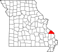
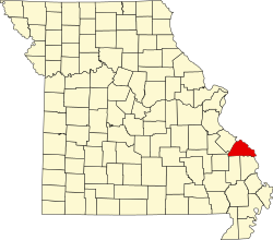
Location of Perry County, Missouri
Coordinates: 37°47′52″N89°51′04″W / 37.79778°N 89.85111°W / 37.79778; -89.85111
Country United States
State Missouri
County Perry
Township Bois Brule
Elevation
[1]
620 ft (190 m)
Time zone UTC-6 (Central (CST))
  Summer (DST) UTC-5 (CDT)
ZIP code
63775
Area code 573
FIPS code 29-66746 [2]
GNIS feature ID726210 [1]

Sereno is an unincorporated community located in Bois Brule Township in Perry County, Missouri, United States. Sereno is located approximately five miles northeast of Perryville.

Contents

Etymology

The early settlers of Sereno named the community Serena, meaning “a clean, respectable place”. However, when establishing a post office they discovered a place by that name already existed in Missouri, so the name was changed to Sereno. [3]

History

In 1884, Thomas Moore gave a small tract of his land along Chester Road to William Mattingly for the purpose of building a general store, which was soon followed by a grist mill. [4] A post office operated from 1888 to 1905. [5] The predominantly Catholic town established Our Lady of Victory Catholic parish in 1908. [6]

References

  1. 1 2 U.S. Geological Survey Geographic Names Information System: Sereno, Missouri
  2. Hometown Locator: Missouri http://www.roadsidethoughts.com/mo/sereno-misc.htm
  3. State Historical Society of Missouri http://shs.umsystem.edu/manuscripts/ramsay/ramsay_perry.html Archived February 9, 2016, at the Wayback Machine
  4. State Historical Society of Missouri: Perry County Place Names http://shs.umsystem.edu/manuscripts/ramsay/ramsay_perry.html Archived February 9, 2016, at the Wayback Machine
  5. Missouri Postal History "Perry". Archived from the original on October 21, 2013. Retrieved September 19, 2013.
  6. Archdiocese of St. Louis http://www.parishesonline.com/scripts/HostedSites/org.asp?p=1&ID=8624