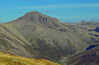
Great Gable is a mountain in the Lake District, United Kingdom. It is named after its appearance as a pyramid from Wasdale, though it is dome-shaped from most other directions. It is one of the most popular of the Lakeland fells, and there are many different routes to the summit. Great Gable is linked by the high pass of Windy Gap to its smaller sister hill, Green Gable, and by the lower pass of Beck Head to its western neighbour, Kirk Fell.

Bowfell is a pyramid-shaped mountain lying at the heart of the English Lake District, in the Southern Fells area. It is the sixth-highest mountain in the Lake District and one of the most popular of the Lake District fells for walkers. It is listed in Alfred Wainwright's 'best half dozen' Lake District fells.

Robinson is a fell in the English Lake District, its southern slopes descending to Buttermere, while its northern side is set in the Newlands Valley. Paths lead to the summit from the village of Buttermere, from the nearby summit Dale Head and from various locations in the valleys to the north.

Great Langdale is a valley in the Lake District National Park in North West England, the epithet Great distinguishing it from the neighbouring valley of Little Langdale. Langdale is also the name of a valley in the Howgill Fells, elsewhere in Cumbria.
High Stile is a mountain in the western part of the Lake District in North West England. It is the eleventh-highest English Marilyn, standing 807 metres (2,648 ft) high, and has a relative height of 362 metres (1,187 ft).

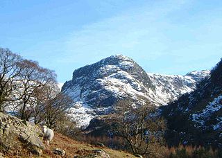
Pike of Stickle, also known as Pike o’ Stickle, is a fell in the English Lake District. It reaches a height of 709 metres (2,326 feet) and is situated in the central part of the national park in the valley of Great Langdale. The fell is one of three fells which make up the picturesque Langdale Pikes, one of the best-known areas in Lakeland. A "stickle" is a hill with a steep prominent rocky top, while a "pike" is a hill with a peaked summit, the name being therefore partly tautological.

Kirk Fell is a fell in the Western part of the English Lake District. It is situated between Great Gable and Pillar on the long ring of fells surrounding the valley of Ennerdale, and also stands over Wasdale to the south. However, it is separated from its two higher neighbours by the low passes of Black Sail and Beck Head, giving it a high relative height and making it a Marilyn, the thirteenth highest in the Lake District.

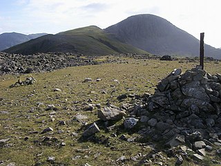
Base Brown is a fell in England's Lake District, near the head of the Borrowdale Valley. It forms one side of the Seathwaite Valley, and on the western side it is flanked by the hanging valley of Gillercomb.
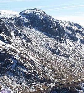
Eagle Crag is a fell in the Lake District in Cumbria, England, it is situated near the village of Stonethwaite where the valleys of Langstrath and Greenup join. Impressive walls of crag look down upon Stonethwaite, making Eagle Crag the most arresting sight from that settlement. It can be climbed direct by the average walker, picking a route between the rock faces.

Red Pike is a fell in the High Stile range in the western English Lake District, which separates Ennerdale from the valley of Buttermere and Crummock Water. It is 2,476 ft (755 m) high. The direct ascent of Red Pike from Buttermere is very popular and the ridge walk from Red Pike to Haystacks is regarded as one of the finest in the area, with excellent views of the Scafells, Great Gable and Pillar.

High Crag stands at the southern end of the High Stile ridge which divides the valleys of Ennerdale and Buttermere in the west of the English Lake District. It is often climbed as part of a popular ridge walk, from Black Sail youth hostel, or from Buttermere via Scarth Gap. Panoramas of the Great Gable and the Scafells are visible.

Scoat Fell is a fell in the western part of the English Lake District. It stands at the head of the Mosedale Horseshoe with its back to Ennerdale. Paths lead to Scoat Fell from Ennerdale over Steeple, from Wasdale over Red Pike, and along the ridge from Pillar.

Ullscarf is a fell in the English Lake District close to the geographical centre of the Cumbrian hills. It forms part of the watershed between the Derwentwater and Thirlmere catchments, a ridge running broadly north-south.

Tarn Crag is a fell in the Central Fells of the English Lake District. Strictly the name refers only to the rock face looking down upon Easedale Tarn, but Alfred Wainwright applied it to the entire ridge lying between the Easedale and Far Easedale valleys in his Pictorial Guide to the Lakeland Fells
Blea Rigg is a fell in the English Lake District, lying between the valleys of Easedale and Great Langdale. One of the Central Fells, it is a broad plateau with a succession of rocky tops. Many routes of ascent are possible, beginning either from Grasmere or Great Langdale, though the paths are often poorly marked and hard to follow.

Calf Crag is a fell in the English Lake District, on the eastern side of the High Raise massif.

Kentmere Pike is a fell in the English Lake District, rising between the valleys of Kentmere and Longsleddale. It is the highpoint on the ridge between Harter Fell and Shipman Knotts.

Rossett Pike is a fell in the English Lake District. It is located at the head of Mickleden, one of two tributary valleys of Great Langdale.
Brandreth is a fell in the English Lake District. It stands between Great Gable and Haystacks in the Western Fells.
The Central Fells are a group of hills in the English Lake District. Reaching their highest point at High Raise, they occupy a broad area to the east of Borrowdale. The Central Fells are generally lower than the surrounding hills, the Lake District's dome-like structure having a slight dip in the middle. The range extends from the boggy ridge between Derwentwater and Thirlmere in the north, to the rock peaks of the Langdale Pikes in the south.