
Sgorr Ruadh is a mountain between Strath Carron and Glen Torridon in Wester Ross in the Northwest Highlands of Scotland. It is located in Coire Lair near Achnashellach along with two other mountains, Beinn Liath Mhòr and Fuar Tholl, and is often climbed together with one or both of these other mountains.

Sgùrr a' Mhàim is a mountain of the Mamores range in the Scottish Highlands. It is directly south of Ben Nevis, on the other side of Glen Nevis. With a height of 1,099 metres (3,605 feet), Sgùrr a' Mhàim is a Munro and the second-highest peak in the Mamores. Its cap of quartzite stones give it a light grey appearance which can be mistaken for a covering of snow.

Sgùrr nan Ceathreamhnan is a mountain in the Northwest Highlands of Scotland. It lies between Glen Affric and Glen Elchaig, some 30 kilometres east of Kyle of Lochalsh. With a height of 1,151 metres (3,776 ft) it is classed as a Munro and ranked as the third highest mountain north of the Great Glen.

Sgurr na Lapaich is a mountain in the Northwest Highlands of Scotland, situated north of Loch Mullardoch in the high ground that separates Glen Cannich and Glen Strathfarrar. The mountain reaches a height of 1,150 metres, and is the fourth-highest mountain north of the Great Glen. There is no higher ground to the north of it in Great Britain.

A' Chralaig is a mountain in the Northwest Highlands of Scotland, north of Loch Cluanie and south of Glen Affric. It is a Munro with a height of 1,120 metres (3,670 ft). It is the highest peak along Glen Shiel and can be easily climbed from the Cluanie Inn on the A87. The eastern slopes of the mountain, are owned by the Forestry Commission and are part of the Kintail National Scenic Area.

Sgùrr Fhuaran is a Scottish mountain that is situated on the northern side of Glen Shiel, 23 kilometres (14 mi) east south east of Kyle of Lochalsh.

Sgùrr na Càrnach is a mountain in the Northwest Highlands of Scotland, one of the 'Five Sisters of Kintail'. It is on the northern side of Glen Shiel, 24 kilometres southeast of Kyle of Lochalsh. It reaches a height of 1,002 metres (3,287 ft) and is classed as a Munro. The summit is rough and boulder-ridden, living up to its Gaelic name which means "peak of the stony place".

Ciste Dhubh is a mountain in the Scottish Highlands, between Glen Shiel and Glen Affric. With a height of 979 metres (3,212 ft), it is classed as a Munro. It is almost surrounded by glens: Fionngleann (north), An Caorann Mòr (east) and Allt Cam-bàn (west), with the Bealach a' Chòinich pass (south) linking it to the mountain of Sgùrr an Fhuarail. Its name comes from Scottish Gaelic A' Chiste Dhubh, "the black chest", possibly referring to the dark rocky summit.

Sgùrr a' Bhealaich Dheirg is a mountain in Kintail on the northern side of Glen Shiel in the Scottish Highlands. With a height of 1,036 metres (3,399 ft), it is classed as a Munro. It is the highest of three Munros known as the "Brothers of Kintail" in contrast to the Five Sisters of Kintail which lie just to the west.

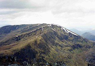
Gairich, sometimes Sgurr Gairoch, is a mountain in Lochaber in the Northwest Highlands of Scotland. It is on the southern side of Loch Quoich, with Glen Garry to the east and Glen Kingie to the south, 25 kilometres north-northwest of Fort William.

Sròn a’ Choire Ghairbh is a Scottish mountain situated on the northern side of Loch Lochy, 13 kilometres north of Spean Bridge in the Highland Council area.
An Riabhachan is a Scottish mountain in the Skye and Lochalsh district of the Highland council area. It is situated 35 kilometres east of Kyle of Lochalsh standing in an isolated position at the western end of Loch Mullardoch, ten kilometres from any public road.

Creise is a mountain summit in the Black Mount range, in the Scottish Highlands. It overlooks the northern end of Glen Etive and its height is 1,100 metres (3,600 ft). Creise is one of four Munros in the Black Mount, along with Meall a' Bhuiridh, Stob Ghabhar and Stob a' Choire Odhair. The mountain is a long and flattish ridge, whose highest point was unnamed until 1981. It is popular with cross-country skiers, being near the White Corries ski area from where it is often climbed along with adjoining Meall a' Bhuiridh. The steep and craggy northern buttress, Sròn na Crèise, is well seen from the A82 road and the Kings House Hotel.
Càrn nan Gobhar is a mountain rising to 993 metres (3,258 ft) in the Northwest Highlands of Scotland. It stands on the northern side of Loch Mullardoch in the upper part of Glen Cannich, in a remote group of four Munros informally known as "The Mullardochs" which form the high ground between Loch Mullardoch and Loch Monar.

Sgùrr nan Clach Geala is a mountain in Wester Ross in the Northwest Highlands of Scotland, south of Ullapool. With a height of 1,093 metres (3,586 ft), it is one of ten Munros in the group of hills known as the Fannichs.

Sgùrr Thuilm is a mountain in the Glenfinnan area of the Highlands of Scotland. It stands at the head of Glen Finnan approximately 7 kilometres (4 mi) north of Loch Shiel.

Càrn nan Gobhar is a mountain rising to 992 metres (3,255 ft) in the Northwest Highlands of Scotland. It lies north of Glen Strathfarrar and south of Glen Orrin, some 40 kilometres west of the city of Inverness. It is usually climbed along with the neighbouring Munros of Sgurr a' Choire Ghlais and Sgurr na Ruaidhe.

Seana Bhràigh is a mountain east of Ullapool, in the Highlands of Scotland.

Sgùrr nan Conbhairean is a mountain in the Northwest Highlands of Scotland, lying north of Loch Cluanie and south of Glen Affric. A dome-shaped mountain with a height of 1,109 metres (3,638 ft), it is part of a group of three Munros, the other two being A' Chràlaig and Mullach Fraoch-choire.
Glen Kingie is a glen or valley in the Northwest Highlands of Scotland which opens onto Glen Garry at its north-eastern end at Kingie. It is drained by the River Kingie which rises at a 650m col between the peaks of An Eag and Sgurr Cos na Breachd-laoidh. The river is fed by numerous burns both to north and south, key amongst which are Allt a' Chinn Bhric, Allt a' Choire Ghlais, Allt Coir' an Stangain Mhoir, Allt a' ùRiabhaich and Allt Torrain Dharaich. The waters of the Kingie enter those of the River Garry at Kingie Pool. Much of the northern side of the glen is formed by the slopes of 1003m high mountain of Sgurr Mor and the 919m high Gairich, both of which are Munros. The more broken southern side is dominated, at least in its upper reaches, by three (Corbetts; the 835m high Sgurr Cos na Breachd-laoidh, the 858m Fraoch Bheinn and the 880m Sgurr Mhurlagain. The glen runs through territory formed by psammites and pelites of the late Precambrian Glenfinnan Group of the Loch Ness Supergroup, a thick sequence of metamorphosed rocks which is intruded by the West Highland Granite Gneiss in the middle section of the glen.


