Central Square is an area in Cambridge, Massachusetts centered on the junction of Massachusetts Avenue, Prospect Street and Western Avenue. Lafayette Square, formed by the junction of Massachusetts Avenue, Columbia Street, Sidney Street and Main Street, is also considered a part of the Central Square area. Harvard Square is to the northwest along Massachusetts Avenue, Inman Square is to the north along Prospect Street and Kendall Square is to the east along Main Street. The section of Central Square along Massachusetts Avenue between Clinton Street and Main Street is designated the Central Square Historic District, and was added to the National Register of Historic Places in 1990.

Chestnut Hill is a wealthy New England village located six miles (10 km) west of downtown Boston, Massachusetts, United States. It is best known for being home to Boston College and a section of the Boston Marathon route. Like all Massachusetts villages, Chestnut Hill is not an incorporated municipal entity. It is located partially in Brookline in Norfolk County; partially in the city of Boston in Suffolk County, and partially in the city of Newton in Middlesex County. Chestnut Hill's borders are defined by the 02467 ZIP Code. The name refers to several small hills that overlook the 135-acre Chestnut Hill Reservoir rather than one particular hill.
Newton Upper Falls is one of the thirteen villages within the city of Newton in Massachusetts, United States. The village is listed as the Newton Upper Falls Historic District on the National Register of Historic Places.

The National Register of Historic Places is a United States federal official list of places and sites considered worthy of preservation. In the state of Massachusetts, there are over 4,300 listings, representing about 5% of all NRHP listings nationwide and the second-most of any U.S. state, behind only New York. Listings appear in all 14 Massachusetts counties.

This is a list of the National Register of Historic Places listings in Plymouth County, Massachusetts.

This is a list of the National Register of Historic Places listings in Franklin County, Massachusetts.
The following properties are listed on the National Register of Historic Places in Arlington, Massachusetts.
This National Park Service list is complete through NPS recent listings posted June 14, 2024.

This is a list of sites listed on the National Register of Historic Places in Cambridge, Massachusetts. This is intended to be a complete list of the properties and districts on the National Register of Historic Places in Cambridge, Massachusetts, United States. Latitude and longitude coordinates are provided for many National Register properties and districts; these locations may be seen together in an online map.

The Shady Lea Historic District is a historic district on Shady Lea and Tower Hill Roads in North Kingstown, Rhode Island. It encompasses a predominantly residential linear district extending along Shady Lea Road southward from Tower Hill Road. Most of the houses along Shady Lea Road are mill worker housing built in the 19th century for workers at the mill complex which stands at the edge of the Shady Lea Mill Pond, at the southern end of the district. This area is a well-preserved example of the numerous rural mill complexes which dotted the Rhode Island countryside in the 19th century.

The Brighton Center Historic District encompasses the civic center of the Brighton neighborhood of Boston, Massachusetts.

The Truman Parkway is a historic parkway in Milton and southern Boston, Massachusetts. It runs along the southern boundary of a portion of the Neponset River Reservation and serves as a connection between the Neponset Valley Parkway and the Blue Hills Parkway. The parkway was built in 1931 and added to the National Register of Historic Places in 2005.

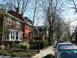
The Avon Hill Historic District is a residential historic district near Porter Square in Cambridge, Massachusetts. Set atop Avon Hill southwest of Porter Square, this subdivision, laid out about 1870, contains a concentration of the finest Victorian and Second Empire residential buildings in the city. The district was listed on the National Register of Historic Places in 1983.

The Francis J. Child House is an historic house at 67 Kirkland Street in Cambridge, Massachusetts. It is a two-story wood-frame structure, with a mansard roof, wooden clapboard siding, and a porch extending across the main facade. The house was built in 1861, and is a distinctive Second Empire cottage with jigsaw-cut molding over its gable windows. The lower (steep) portion of the mansard roof has hexagonal tiles, and the building retains its original siding.

The E. E. Cummings House is an historic house at 104 Irving Street in Cambridge, Massachusetts. The house was the childhood home of author and poet E. E. Cummings. The Colonial Revival house was built in 1893 for Cummings' parents, and was listed on the National Register of Historic Places in 1983.

The Harvard Street Historic District is a historic district on Harvard Street between Ellery and Hancock Streets in Cambridge, Massachusetts. It includes houses on both sides of the street, numbered from 335 to 344 inclusive, an area that marks the summit of Dana Hill. Harvard Street was laid out as a direct route from "Old Cambridge" to Boston in the early 1800s, and was run over Dana Hill over the objection of Judge Francis Dana, whose estate sat on top of the hill. The street was developed over the 19th century with a succession of high-quality houses.

The Fort Hill Rural Historic District is a historic district encompassing two farmsteads with more than 200 years of history in Eastham, Massachusetts. The district is a 100-acre (40 ha) area of forest, fields, and salt marshes that was owned by the Knowles and Penninman families from 1742 to 1941. It has been part of the Cape Cod National Seashore since 1961. The area is dominated by the rise called "Fort Hill", which provides extensive views of the area and has its own rich history. The district includes the Edward Penniman House and Barn, previously listed on the National Register of Historic Places, and the Nauset Archeological District, a National Historic Landmark.

The Common Historic District is a historic district encompassing the civic and institutional heart of Reading, Massachusetts. The district is centered on the town common, at the intersection of Main and Salem Streets. The common has been communally owned since at least 1737, with the original burying ground to the north. In 1769 the area's first meeting house was built, giving the area a sense of identity separate from portions of Reading that would later be set off as Wakefield and North Reading. Since then the area has become a focal point for religious and civic institutions in the town.

The Middlesex Fells Reservoirs Historic District is a historic district roughly bounded by Pond St., Woodland Rd., I-93, and MA 28 in Stoneham and Medford, Massachusetts. It encompasses a portion of the Middlesex Fells Reservation, a state park managed by the Massachusetts Department of Conservation and Recreation (DCR). The principal features of the district are three reservoirs and their associated gate houses and pumping stations, which were developed by the Metropolitan District Commission starting in the late 19th century. The district was listed on the National Register of Historic Places in 1990.

Chestnut Hill Reservation is a public recreation area and historic preserve surrounding the Chestnut Hill Reservoir in the Chestnut Hill and Brighton neighborhoods of Boston, Massachusetts, United States. The reserve is part of the Chestnut Hill Reservoir Historic District, is listed on the National Register of Historic Places, and is a City of Boston Landmark. It is managed by the Department of Conservation and Recreation.

Fort Hill is a 0.4 square mile neighborhood and historic district of Roxbury, in Boston, Massachusetts. The approximate boundaries of Fort Hill are Malcolm X Boulevard on the north, Washington Street on the southeast, and Columbus Avenue on the southwest.