
Bedford is a town in Middlesex County, Massachusetts, United States. The population of Bedford was 14,161 at the 2022 United States census.

Pinehurst is an unincorporated village and census-designated place (CDP) in the town of Billerica, Middlesex County, Massachusetts, United States. The population was 7,368 at the 2020 census. It is in the southeastern part of town along Massachusetts Route 3A.

Harvard Yard, in Cambridge, Massachusetts, is the oldest part of the Harvard University campus, its historic center and modern crossroads. It contains most of the freshman dormitories, Harvard's most important libraries, Memorial Church, several classroom and departmental buildings, and the offices of senior University officials including the President of Harvard University.

Mount Auburn Cemetery, located in Cambridge and Watertown, Massachusetts, is the first rural or garden cemetery in the United States. It is the burial site of many prominent Boston Brahmins, and is a National Historic Landmark.

Forest Hills Cemetery is a historic 275-acre (111.3 ha) rural cemetery, greenspace, arboretum, and sculpture garden in the Forest Hills section of Jamaica Plain, a neighborhood in Boston, Massachusetts. The cemetery was established in 1848 as a public municipal cemetery for Roxbury, Massachusetts, but was privatized when Roxbury was annexed to Boston in 1868.
The Charles Street Meeting House is an early-nineteenth-century historic church in Beacon Hill at 70 Charles Street, Boston, Massachusetts.

The Shawsheen River is a 26.7-mile-long (43.0 km) tributary of the Merrimack River in northeast Massachusetts. The name has had various spellings. According to Bailey's history of Andover, the spelling Shawshin was the most common in the old records, although Shawshine, Shashin, Shashine, Shashene, Shawshene, and later, Shawsheen, are found. The name, says Bailey, is said to mean "Great Spring".

North Billerica is an unincorporated village of the town of Billerica, Massachusetts, United States, one of the nine sections (hamlets) that make up the Town of Billerica. It is the home to Faulkner and Talbot mills and the North Billerica Train Depot. The Middlesex Canal was built through the village in 1783 and the Boston and Lowell Railroad was put through in the 1840s.

The West Parish Burying Ground, also known as the River Street Burying Ground or River Street Cemetery, is a cemetery located at River and Cherry streets in West Newton, Massachusetts, and is listed on the National Register of Historic Places. Established in 1777, the cemetery is owned and maintained by the City of Newton; the Second Church in Newton, its original owner, was known as the West Parish.

Boston College Main Campus Historic District encompasses the historic heart of the campus of Boston College in the Chestnut Hill area of Newton, Massachusetts. It consists of a collection of six Gothic Revival stone buildings, centered on Gasson Hall, designed by Charles Donagh Maginnis and begun in 1909.
East Parish Burying Ground, also known as Centre Street Burying Ground or Centre Street Cemetery, is an historic cemetery located at Centre and Cotton streets in the village of Newton Corner in the city of Newton, Massachusetts. On December 23, 1983, it was listed on the National Register of Historic Places. It has been called the "most important, the most evocative and also the most fragile historic site in the city."

Prospect Hill Cemetery is a historic cemetery on Auburn Road in Millis, Massachusetts. Founded in 1714, it is the town's only cemetery. Covering more than 18 acres (7.3 ha), it has more than 2,800 burials. Among those buried in the cemetery are politician Christian Herter, who served as U.S. Secretary of State and Governor of Massachusetts, and two Medal of Honor recipients, Charles Church Roberts and William D. Newland. The cemetery was listed on the National Register of Historic Places in 2006 with the help of a short documentary film by a Millis High School Freshman Dustin Fresh.

The West Parish Center District encompasses the social and religious center of the part of Andover, Massachusetts, that is located west of the Shawsheen River. It is mostly spread along Lowell Street on either side of a major intersection with four other roads: Shawsheen Road, Reservation Road, Beacon Street, and High Plain Road. The centerpiece of the district is the 1826 West Parish Church, which is the oldest church standing in Andover. It is an elegant Federal style granite structure topped with a wooden steeple, added in 1863. The roof is made of Spanish tile, which was probably part of changes made around 1908. Opposite the church on the south side of the common is the West Parish Cemetery, which began as a small burying ground in the 1790s, and was substantially enlarged and restyled in the early 1900s.

Shawsheen Village Historic District is a historic district in northern Andover, Massachusetts. Shawsheen Village was completed in the early 1920s as a planned corporate community. Conceived by William Madison Wood of the American Woolen Company, the village was designed a team of architects including Adden & Parker, Clifford Allbright and Ripley & LeBoutillier of Boston and James E. Allen of Lawrence. John Franklin, a civil engineer for the American Woolen Company was responsible for designing the village, under the direction of Wood. Buildings from the original Frye Village were also incorporated into the design which included a railroad station, shops, apartment buildings, factories, parks and numerous single-family dwellings. The village was located just up the road from the Company's main factories in nearby Lawrence.

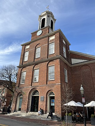
The Bedford Center Historic District encompasses the historic heart of the town of Bedford, Massachusetts. It extends along Great Road between Bacon and Concord Roads, and includes primarily residential areas on adjacent side streets. The area includes the town's main civic buildings, its first cemetery, and a diverse array of residential architecture spanning more than two centuries. The district was listed on the National Register of Historic Places in 1977; its boundaries were adjusted in 2014 and its period of significance extended.
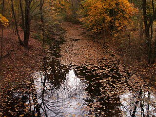
Vine Brook is a brook in Middlesex County, Massachusetts. According to the History of Bedford, Vine Brook is "an important tributary of Shawsheen River." The book also states it as an excellent source of water-power in the 17th to 19th Centuries.

Walnut Hills Cemetery is a historic cemetery on Grove Street and Allandale Road in Brookline, Massachusetts. It encompasses 45.26 acres (18.32 ha), with mature trees and puddingstone outcrops, and was laid out in 1875 in the then-fashionable rural cemetery style. Many past prominent citizens of the town, including architect H. H. Richardson, are buried here. The cemetery was listed on the National Register of Historic Places in 1985.
Nathaniel Cannon Smith (1866–1943), professionally known as Nat. C. Smith, was an American painter and architect of New Bedford, Massachusetts.

The Jewish Cemetery of New Bedford, Massachusetts is located in the far north of the city, on Old Plainville Road, just north of New Bedford Regional Airport. The cemetery was established in 1898 as the principal burying ground for two congregations, Chesed Shel Emes and Ahavath Achim. It is the second Jewish cemetery in the city; the first, a small section of Peckham West Cemetery, was filled up in the 1890s. The developed portion of the cemetery lands is about 13 acres (5.3 ha), with another 24.5 acres (9.9 ha) that is undeveloped forest. The cemetery land is now owned by a number of organizations: the Tifereth Israel congregation owns about 19 acres (7.7 ha), Ahavath Achim owns 5.25 acres (2.12 ha), and two small parcels are owned by other organizations. Entrances to the cemetery are marked by stone posts with bronze plaques. There is also the Temple Sinai section that sits in the grounds of the New Bedford airport that was accessible from the Old Plainville Road but is now blocked off.
The Rural Cemetery and Friends Cemetery are a pair of connected cemeteries at 149 Dartmouth Street in New Bedford, Massachusetts United States. They occupy an irregular parcel of land more than 90 acres (36 ha) in size on the west side of the city. Established in 1837, the Rural Cemetery was the fifth rural cemetery in the nation, after Mount Auburn Cemetery, Mount Hope Cemetery, Mount Pleasant Cemetery, and Laurel Hill Cemetery. In its early days it was criticized as lacking some of the natural beauty afforded by rolling terrain; the early sections were laid out in rectilinear manner on relatively flat terrain. The cemetery was a popular burial site, including notably the landscape artist Albert Bierstadt and Governor of Massachusetts John H. Clifford.


