
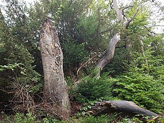
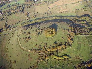
Whitehorse Hill is a hill in the Berkshire Downs in Oxfordshire, England, west of Wantage. At 261 metres (856 ft), it is the highest point in Oxfordshire. Uffington Castle lies on the summit of the hill, and the Uffington White Horse is on the hill's northern slope. The hill and an adjacent area below, including Dragon Hill and The Manger, make up a 98.9-hectare (244-acre) biological and geological Site of Special Scientific Interest.

Windsor Hill is a 61.8-hectare (153-acre) biological Site of Special Scientific Interest near Princes Risborough in Buckinghamshire. It lies within the Chilterns Area of Outstanding Natural Beauty, and it is featured in the Nature Conservation Review. A small part is managed by the Berkshire, Buckinghamshire and Oxfordshire Wildlife Trust, and access to this area requires a permit.

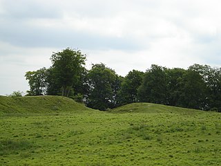
Camp Down is a 7.3-hectare (18-acre) biological Site of Special Scientific Interest in Wiltshire in South West England. It was designated as such in 1965.
Chipstead Downs is a 157.8-hectare (390-acre) biological Site of Special Scientific Interest south-east of Banstead in Surrey, England. Part of it is Park Downs, which is managed by the Banstead Commons Conservators.
St. Catherine's Hill is a chalk downland hill and 43-hectare (110-acre) biological Site of Special Scientific Interest on the outskirts of Winchester in Hampshire, England. It is owned by Winchester College but open to the public. It is managed by Hampshire and Isle of Wight Wildlife Trust, and topped by an Iron Age hillfort, a scheduled monument. In the Black Death, plague pits were dug in the dry valley on the south side of the hill. In the Early modern period, a mizmaze was cut on the hilltop. Winchester College football used to be played on the hill; in an old custom, members of the college assemble on the hill every year, early in the morning.

Quarry Hangers is a 28.5-hectare (70-acre) biological Site of Special Scientific Interest south-west of Caterham in Surrey. An area of 11 hectares is a nature reserve managed by the Surrey Wildlife Trust.

Woldingham and Oxted Downs is a 128.4-hectare (317-acre) biological Site of Special Scientific Interest east of Caterham in Surrey.

Aston Rowant National Nature Reserve is located on the north-west escarpment of the Chiltern Hills, in the Chilterns Area of Outstanding Natural Beauty. It has an area of 159.1 hectares, and most of it is a 128.5 hectares biological Site of Special Scientific Interest. It is listed as a Grade 1 site in A Nature Conservation Review. The reserve is in several sections, mostly in the parish of Lewknor in Oxfordshire, with smaller sections in the parish of Stokenchurch in Buckinghamshire.
Galley and Warden Hills is a 47 hectare biological Site of Special Scientific Interest in Warden Hill, a suburb of Luton in Bedfordshire. The local planning authority is Central Bedfordshire Council, and it was notified in 1986 under Section 28 of the Wildlife and Countryside Act 1981. It is also a Local Nature Reserve.

Pitstone Hill is a 22.9-hectare (57-acre) biological Site of Special Scientific Importance east of Pitstone in Buckinghamshire. It is in the Chilterns Area of Outstanding Natural Beauty, and is crossed by the Ridgeway National Trail.

Hackpen, Warren & Gramp's Hill Downs is a 71.4-hectare (176-acre) biological Site of Special Scientific Interest in Letcombe Bassett in Oxfordshire.

Roughdown Common is a 3.6-hectare (8.9-acre) biological Site of Special Scientific Interest in Hemel Hempstead in Hertfordshire. The planning authority is Dacorum Borough Council. The site is Common land, and it is owned by the Box Moor Trust having been officially bought by the trust in April 1886 from the Dean and Chapter of St Paul's. It is part of the Chilterns Area of Outstanding Natural Beauty. The Common is a steeply sloping chalk hill in south Hemel Hempstead.

Bacombe and Coombe Hills is a 76.4-hectare (189-acre) biological Site of Special Scientific Interest in Upper Bacombe in Buckinghamshire. Bacombe Hill was formerly owned by Buckinghamshire County Council, which transferred it to Berkshire, Buckinghamshire and Oxfordshire Wildlife Trust in 2014. Coombe Hill is owned by the National Trust.

Ivinghoe Hills is a 210.4 hectares Site of Special Scientific Interest in Ivinghoe in Buckinghamshire, and part of the Chilterns Area of Outstanding Natural Beauty. It is listed in A Nature Conservation Review. The Ridgeway long-distance footpath ends and the Icknield Way Path starts in the site on Ivinghoe Beacon. An Iron Age fort on Ivinghoe Beacon and a tumulus on Gallows Hill are Scheduled Monuments. The site is part of the National Trust's Ashridge Estate, apart from a small area which belongs to Buckinghamshire County Council.

Lodge Hill is a 31.8-hectare (79-acre) Site of Special Scientific Interest north of Bledlow Ridge in Buckinghamshire. The local planning authorities are Wycombe District Council and Buckinghamshire County Council. The site is in the Chilterns Area of Outstanding Natural Beauty, and The Ridgeway long-distance footpath crosses it.

Dancersend Waterworks is a 4-hectare biological Site of Special Scientific Interest in Spencersgreen south of Aston Clinton in Buckinghamshire. It was formerly a private waterworks supplying the Rothschild Dancersend estate, and is now owned by Thames Water. It is in the Chilterns Area of Outstanding Natural Beauty. A cooling pond within the Thames Water site is a Grade II listed building.

Swyncombe Downs is a 47.1-hectare (116-acre) biological Site of Special Scientific Interest east of Wallingford in Oxfordshire.

Watlington and Pyrton Hills is a 112.7-hectare (278-acre) biological Site of Special Scientific Interest east of Watlington in Oxfordshire. An area of 1.6 hectares is Watlington Chalk Pit, which is a Local Nature Reserve.
Watlington Chalk Pit is a 1.6-hectare (4.0-acre) Local Nature Reserve east of Watlington in Oxfordshire. It is owned by South Oxfordshire District Council and managed by Watlington Parish Council and Watlington Environment Group. It is part of Watlington and Pyrton Hills Site of Special Scientific Interest.
Danebury Hill is a 13.7-hectare (34-acre) biological Site of Special Scientific Interest north-east of Nether Wallop in Hampshire. It is part of Danebury Hillfort Local Nature Reserve.
