
The Berkshire, Buckinghamshire and Oxfordshire Wildlife Trust (BBOWT), is a wildlife trust covering the counties of Berkshire, Buckinghamshire and Oxfordshire in England.

Hartslock, also known as Hartslock Woods, is a 41.8-hectare (103-acre) biological Site of Special Scientific Interest (SSSI) in a wooded area on the north bank of the River Thames to the south-east of Goring-on-Thames in the English county of Oxfordshire. An area of 29.4 hectares is a Special Area of Conservation and an area of 10 hectares is a nature reserve owned and managed by the Berkshire, Buckinghamshire and Oxfordshire Wildlife Trust (BBOWT). The site is well known for the variety of wild orchids that grow on its sloping grassland, and especially for the monkey orchid that grows in very few other places in England.
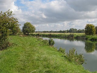
Chimney is a hamlet on the River Thames near Shifford Lock, 6 miles (9.7 km) south of Witney in Oxfordshire. It is part of the civil parish of Aston, Cote, Shifford and Chimney. Chimney Meadows 620 acres (250 ha) is the largest nature reserve managed by the Berkshire, Buckinghamshire and Oxfordshire Wildlife Trust.

Moor Copse is a 65-hectare (160-acre) nature reserve west of Reading in Berkshire. It is managed by the Berkshire, Buckinghamshire and Oxfordshire Wildlife Trust. Parts of it are in Sulham and Tidmarsh Woods and Meadows, which is a Site of Special Scientific Interest.
Bix Bottom is a 102.3-hectare (253-acre) biological Site of Special Scientific Interest north-west of Henley-on-Thames in Oxfordshire. It is owned and managed as Warburg Nature Reserve by the Berkshire, Buckinghamshire and Oxfordshire Wildlife Trust.

Glyme Valley is a 28.9-hectare (71-acre) biological Site of Special Scientific Interest east of Chipping Norton in Oxfordshire. An area of 3 hectares is a nature reserve managed by the Berkshire, Buckinghamshire and Oxfordshire Wildlife Trust

Wildmoor Heath is a 91-hectare (220-acre) nature reserve south of Crowthorne in Berkshire. It is managed by the Berkshire, Buckinghamshire and Oxfordshire Wildlife Trust. The reserve is part of two Sites of Special Scientific Interest: Wildmoor Heath itself is part of Sandhurst to Owlsmoor Bogs and Heaths and a separate area called Broadmoor Bottom is part of Broadmoor to Bagshot Woods and Heaths.

Rack Marsh is a 4-hectare (9.9-acre) nature reserve in Bagnor, on the north-western outskirts of Newbury in Berkshire. It is managed by the Berkshire, Buckinghamshire and Oxfordshire Wildlife Trust. It is part of Kennet and Lambourn Floodplain, which is a Biological Site of Special Scientific Interest, and a Nature Conservation Review site. It is also part of the Kennet and Lambourn Floodplain Special Area of Conservation.

Inkpen Common or Inkpen Great Common is a 12.8-hectare (32-acre) biological Site of Special Scientific Interest east of Inkpen in Berkshire. It is managed as a nature reserve by the Berkshire, Buckinghamshire and Oxfordshire Wildlife Trust.

Woodsides Meadow is a 4-hectare (9.9-acre) nature reserve south of Wendlebury in Oxfordshire. It is managed by the Berkshire, Buckinghamshire and Oxfordshire Wildlife Trust. It is part of Wendlebury Meads and Mansmoor Closes, which is a Site of Special Scientific Interest.

Dry Sandford Pit is a 4.2-hectare (10-acre) biological and geological Site of Special Scientific Interest north-west of Abingdon-on-Thames in Oxfordshire. It is a Geological Conservation Review site and it is managed as a nature reserve by the Berkshire, Buckinghamshire and Oxfordshire Wildlife Trust.

Iffley Meadows is a 36.1-hectare (89-acre) biological Site of Special Scientific Interest in Oxford in Oxfordshire. It is owned by Oxford City Council and managed by the Berkshire, Buckinghamshire and Oxfordshire Wildlife Trust

Parsonage Moor is a 6-hectare (15-acre) nature reserve north-west of Abingdon-on-Thames in Oxfordshire, United Kingdom. It is managed by the Berkshire, Buckinghamshire and Oxfordshire Wildlife Trust. It is part of Cothill Fen, which is a Site of Special Scientific Interest and Special Area of Conservation. Part of it is in Cothill Fen and Parsonage Moor Nature Conservation Review site, Grade I.
Cothill Fen is a 43.3-hectare (107-acre) biological and geological Site of Special Scientific Interest north-west of Abingdon-on-Thames in Oxfordshire. It is a Special Area of Conservation and parts of it are a Geological Conservation Review site, a Nature Conservation Review site, Grade 1, and a National Nature Reserve. It also includes two areas which are nature reserves managed by the Berkshire, Buckinghamshire and Oxfordshire Wildlife Trust, Lashford Lane Fen and Parsonage Moor.

Hitchcopse Pit is a 3-hectare (7.4-acre) nature reserve north-west of Abingdon-on-Thames in Oxfordshire. It is managed by the Berkshire, Buckinghamshire and Oxfordshire Wildlife Trust. It is part of Frilford Heath, Ponds and Fens, which is a Site of Special Scientific Interest.

Bould Wood is a 58.2-hectare (144-acre) biological Site of Special Scientific Interest north of Shipton-under-Wychwood in Oxfordshire. An area of 23 hectares is Foxholes nature reserve, which is managed by the Berkshire, Buckinghamshire and Oxfordshire Wildlife Trust.

Lashford Lane Fen is a 7-hectare (17-acre) nature reserve north of Dry Sandford in Oxfordshire. It is managed by the Berkshire, Buckinghamshire and Oxfordshire Wildlife Trust. It is part of Cothill Fen, which is a Site of Special Scientific Interest and Special Area of Conservation.
