
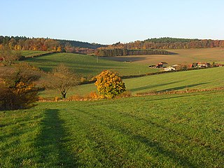
Bernwood Forest is a forest in England. Historically it was one of several forests of the ancient Kingdom of England and was a Royal hunting forest. It is thought to have been set aside as Royal hunting land when the Anglo-Saxon kings had a palace at Brill and church in Oakley, in the 10th century and was a particularly favoured place of Edward the Confessor, who was born in nearby Islip.

The Berkshire, Buckinghamshire and Oxfordshire Wildlife Trust (BBOWT), is a Wildlife Trust covering the counties of Berkshire, Buckinghamshire and Oxfordshire in England.

Moor Copse is a 65-hectare (160-acre) nature reserve west of Reading in Berkshire. It is managed by the Berkshire, Buckinghamshire and Oxfordshire Wildlife Trust. Parts of it are in Sulham and Tidmarsh Woods and Meadows, which is a Site of Special Scientific Interest.
Bix Bottom is a 102.3-hectare (253-acre) biological Site of Special Scientific Interest north-west of Henley-on-Thames in Oxfordshire. It is owned and managed as Warburg Nature Reserve by the Berkshire, Buckinghamshire and Oxfordshire Wildlife Trust.
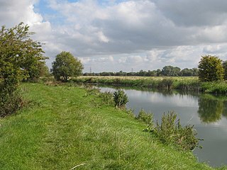
Chimney Meadows is a 49.6-hectare (123-acre) biological Site of Special Scientific Interest between Abingdon-on-Thames and Faringdon in Oxfordshire. It is also a national nature reserve, and part of the 308-hectare (760-acre) Chimney Meadows nature reserve, which is managed by the Berkshire, Buckinghamshire and Oxfordshire Wildlife Trust.

Glyme Valley is a 28.9-hectare (71-acre) biological Site of Special Scientific Interest east of Chipping Norton in Oxfordshire. An area of 3 hectares is a nature reserve managed by the Berkshire, Buckinghamshire and Oxfordshire Wildlife Trust

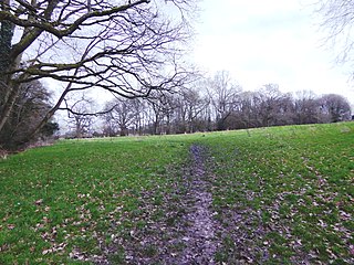
Bucklebury Common is an elevated common consisting of woodland with a few relatively small clearings in the English county of Berkshire, within the civil parish of Bucklebury centred 3 miles (4.8 km) northeast of Thatcham and encircling the settled localities of Upper Bucklebury and Chapel Row. It is one of the largest commons in Southern England covering 350 hectares. Since Inclosure the area is privately owned by the Bucklebury Manor estate, but has public access on a network of public rights of way bolstered by the Countryside and Rights of Way Act 2000.

Bacombe and Coombe Hills is a 76.4-hectare (189-acre) biological Site of Special Scientific Interest in Upper Bacombe in Buckinghamshire. Bacombe Hill was formerly owned by Buckinghamshire County Council, which transferred it to Berkshire, Buckinghamshire and Oxfordshire Wildlife Trust in 2014. Coombe Hill is owned by the National Trust.

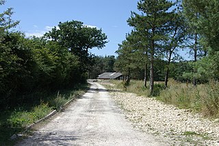
Shabbington Woods Complex is a 305.6-hectare (755-acre) biological Site of Special Scientific Interest (SSSI) between Horton-cum-Studley and Worminghall in Buckinghamshire. It comprises Shabbington Wood, Bernwood Forest, Hell Coppice, Oakley Wood and York's Wood. Shabbington Wood is owned by the Forestry Commission, and a small area of 7.5 hectares called Bernwood Meadows is managed by the Berkshire, Buckinghamshire and Oxfordshire Wildlife Trust.

Long Herdon Meadow is a 4.5-hectare (11-acre) biological Site of Special Scientific Interest south of Marsh Gibbon in Buckinghamshire. It is part of Upper Ray Meadows nature reserve, which is managed by the Berkshire, Buckinghamshire and Oxfordshire Wildlife Trust.

Upper Ray Meadows is a 181-hectare nature reserve, managed by the Berkshire, Buckinghamshire and Oxfordshire Wildlife Trust, south of Marsh Gibbon in Buckinghamshire. It is composed of a number of areas, one of which, Long Herdon Meadow, is a biological Site of Special Scientific Interest.

Yoesden, often known as Yoesden Bank, is a 13-hectare (32-acre) nature reserve in Bledlow Ridge in Buckinghamshire. It is managed by the Berkshire, Buckinghamshire and Oxfordshire Wildlife Trust. It is in the Chilterns Area of Outstanding Natural Beauty.

Hosehill Lake is a 23.6-hectare (58-acre) Local Nature Reserve west of Reading in Berkshire. It is owned by West Berkshire Council and managed by the Berkshire, Buckinghamshire and Oxfordshire Wildlife Trust.
Audrey's Meadow is a 2-hectare (4.9-acre) nature reserve in Newbury in Berkshire. It is owned by West Berkshire Council and managed by the Berkshire, Buckinghamshire and Oxfordshire Wildlife Trust.

Woodsides Meadow is a 4-hectare (9.9-acre) nature reserve south of Wendlebury in Oxfordshire. It is managed by the Berkshire, Buckinghamshire and Oxfordshire Wildlife Trust. It is part of Wendlebury Meads and Mansmoor Closes, which is a Site of Special Scientific Interest.

Iffley Meadows is a 36.1-hectare (89-acre) biological Site of Special Scientific Interest in Oxford in Oxfordshire. It is owned by Oxford City Council and managed by the Berkshire, Buckinghamshire and Oxfordshire Wildlife Trust
Whitecross Green and Oriel Woods is a 63-hectare (160-acre) biological Site of Special Scientific Interest between Oxford and Bicester in Oxfordshire. It is owned and managed by the Berkshire, Buckinghamshire and Oxfordshire Wildlife Trust under the name Whitecross Green Wood.
Blenheim Farm is a 1-hectare (2.5-acre) nature reserve near Charlbury in Oxfordshire. It is owned and managed by the Berkshire, Buckinghamshire and Oxfordshire Wildlife Trust.

Oakley Hill is a 13-hectare (32-acre) nature reserve south of Chinnor in Oxfordshire, England. It is managed by the Berkshire, Buckinghamshire and Oxfordshire Wildlife Trust.

Bould Wood is a 58.2-hectare (144-acre) biological Site of Special Scientific Interest north of Shipton-under-Wychwood in Oxfordshire. An area of 23 hectares is Foxholes nature reserve, which is managed by the Berkshire, Buckinghamshire and Oxfordshire Wildlife Trust.
