Hartslock

Last updated

Hartslock
Site of Special Scientific Interest
Hartslock 03.jpg
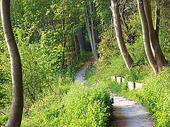
View from the top of the nature reserve over woods and river
Oxfordshire UK location map.svg
Red pog.svg
Location within Oxfordshire
Location Oxfordshire
Grid reference SU 619 790 [1]
Coordinates 51°30′25″N1°06′36″W / 51.507°N 1.110°W / 51.507; -1.110
InterestBiological
Area41.8 hectares (103 acres) [1]
Notification 1986 [1]
Location map Magic Map

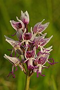
Hartslock, also known as Hartslock Woods, is a 41.8-hectare (103-acre) biological Site of Special Scientific Interest (SSSI) in a wooded area on the north bank of the River Thames to the south-east of Goring-on-Thames in the English county of Oxfordshire. [1] [2] An area of 29.4 hectares (73 acres) is a Special Area of Conservation [3] and an area of 10 hectares (25 acres) is a nature reserve owned and managed by the Berkshire, Buckinghamshire and Oxfordshire Wildlife Trust (BBOWT). [4] [5] The site is well known for the variety of wild orchids that grow on its sloping grassland, and especially for the monkey orchid (Orchis simia) that grows in very few other places in England. [4]

The name Hartslock is believed to derive from the Hart family, who in the 15th century owned a 'lock', probably a wooden construction used to support nets and eel traps, across the river below the woods. This structure no longer exists, having been removed in stages during the 19th and early 20th centuries. In 1915, Hartslock Wood was one of the sites listed by Charles Rothschild, the founder of the Wildlife Trusts, as "worthy of preservation", although the exigencies of the First World War meant that no practical steps were taken to protect it then. In 1950s and 60s, local residents reacted to encroaching agriculture by helping to monitor and protect the orchids, and in 1975/76 BBOWT bought part of the site and established it as a nature reserve. In 1986, the whole site was designated as an SSSI. [1] [6] [7]

The site has diverse semi-natural habitats, including species-rich chalk downland, ancient yew woodland, semi-natural broadleaved woodland, riverside fen and scrub. The wood has a variety of tree species including beech and yew, and there is a large colony of badgers. Besides the monkey orchid, several other orchid species, including lady (Orchis purpurea), bee (Ophrys apifera), pyramidal (Anacamptis pyramidalis), common spotted (Dactylorhiza fuchsii), common twayblade (Neottia ovata) and white helleborine (Cephalanthera damasonium), are to be found on the steeply sloping grassland part of the site. A hybrid of the monkey and lady orchids has been reported at Hartslock, the only place in Britain where this hybrid has been recorded. [4] [7] [8]

The Thames Path passes through Hartslock Woods. The path is usually at some distance from the river, as this is a stretch of the path that is not based on the old Thames towpath, which is on the opposite bank at this point.

Related Research Articles

<span class="mw-page-title-main">Berkshire, Buckinghamshire and Oxfordshire Wildlife Trust</span> Wildlife conservation charity

The Berkshire, Buckinghamshire and Oxfordshire Wildlife Trust (BBOWT), is a Wildlife Trust covering the counties of Berkshire, Buckinghamshire and Oxfordshire in England.

<span class="mw-page-title-main">Lower Woods</span>

Lower Woods is a 280.1-hectare (692-acre) biological and geological Site of Special Scientific Interest near the village of Wickwar, South Gloucestershire, notified in 1966 and renotified in 1985. The site area has increased at last revision in 1974 to a 284.1-hectare (702-acre) site. The site is a nature reserve managed by the Gloucestershire Wildlife Trust.

<span class="mw-page-title-main">Strawberry Banks</span> Biological Site of Special Scientific Interest in Gloucestershire, England

Strawberry Banks is a 5.06-hectare (12.5-acre) biological Site of Special Scientific Interest in Gloucestershire, notified in 1993.

<span class="mw-page-title-main">Bowdown and Chamberhouse Woods</span>

Bowdown and Chamberhouse Woods is a 67.9-hectare (168-acre) biological Site of Special Scientific Interest south of Thatcham in Berkshire. An area of 55 hectares is a nature reserve managed by the Berkshire, Buckinghamshire and Oxfordshire Wildlife Trust.

<span class="mw-page-title-main">Totternhoe Knolls</span>

Totternhoe Knolls is a 13.1-hectare (32-acre) Site of Special Scientific Interest (SSSI) in Totternhoe in Bedfordshire. It is also a local nature reserve, and part of the Chilterns Area of Outstanding Natural Beauty. The site is owned by Central Bedfordshire Council and leased to the National Trust. Most of the site is maintained jointly by the National Trust and the Wildlife Trust for Bedfordshire, Cambridgeshire and Northamptonshire (WTBCN), and is part of the WTBCN Totternhoe nature reserve, which also includes Totternhoe Chalk Quarry and Totternhoe Stone Pit. The SSSI also includes Totternhoe Castle, the earthworks of a Norman motte-and-bailey castle which is a Scheduled monument.

<span class="mw-page-title-main">Sulham and Tidmarsh Woods and Meadows</span>

Sulham and Tidmarsh Woods and Meadows is a 75.7-hectare (187-acre) biological Site of Special Scientific Interest west of Reading in Berkshire. Previously known as Pang Valley SSSI, the site is mostly sandwiched between the River Pang and the Sulham Road and includes Broom Copse, Herridge's Copse, Hogmoor Copse, Park Wood, Moor Copse and Barton's Copse. Much of the southern part of the site is the Berkshire, Buckinghamshire and Oxfordshire Wildlife Trust's Moor Copse Nature Reserve. The whole site lies within the North Wessex Downs Area of Outstanding Natural Beauty.

<span class="mw-page-title-main">Downe Bank</span>

Downe Bank is a nature reserve owned and managed by the Kent Wildlife Trust in the North Downs, close to Downe in the London Borough of Bromley. It is a Site of Special Scientific Interest (SSSI) together with the neighbouring High Elms Country Park. Located close to Charles Darwin's home, Down House, it was one of his favourite places and helped to inspire his work.

<span class="mw-page-title-main">Brassey SSSI</span> Biological Site of Special Scientific Interest in Gloucestershire, England

Brassey is a 2.1-hectare (5.2-acre) biological Site of Special Scientific Interest in Gloucestershire, notified in 1954 and renotified in 1983. It is situated on the north side of the Windrush Valley, midway between Naunton and Upper Slaughter. The reserve comprises sloping, unimproved limestone pasture. There is a fast-flowing stream. This site is one of the few freshwater marshes in Gloucestershire. The stream joins the River Windrush.

<span class="mw-page-title-main">Daneway Banks SSSI</span> Biological Site of Special Scientific Interest in Gloucestershire, England

Daneway Banks is a 17-hectare (42-acre) biological Site of Special Scientific Interest in Gloucestershire, notified in 1954 and renotified in 1983. It lies half a mile west of Sapperton and is part of a group of wildlife sites in the Frome Valley that includes Siccaridge Wood and Sapperton Canal reserves. The site is in the Cotswold Area of Outstanding Natural Beauty.

Lower Wye Gorge is a 65-hectare (160-acre) biological and geological Site of Special Scientific Interest in Gloucestershire, notified in 1954 and renotified 1987. The site includes two Gloucestershire Wildlife Trust nature reserves being Ban-y-gor Wood and Lancaut. The Natural England citation states a revision for Lancaut inclusion.

<span class="mw-page-title-main">Bull Cross, The Frith and Juniper Hill</span> Site of Special Scientific Interest in Gloucestershire, England

Bull Cross, The Frith and Juniper Hill is a 42.33-hectare (104.6-acre) biological and geological Site of Special Scientific Interest in Gloucestershire, notified in 1954. The site is listed in the ‘Stroud District’ Local Plan, adopted November 2005, Appendix 6 as an SSSI and Regionally Important Geological Site (RIGS).

<span class="mw-page-title-main">Bacombe and Coombe Hills</span>

Bacombe and Coombe Hills is a 76.4-hectare (189-acre) biological Site of Special Scientific Interest in Upper Bacombe in Buckinghamshire. Bacombe Hill was formerly owned by Buckinghamshire County Council, which transferred it to Berkshire, Buckinghamshire and Oxfordshire Wildlife Trust in 2014. Coombe Hill is owned by the National Trust.

<span class="mw-page-title-main">Dancersend</span>

Dancersend is an 81.3-hectare (201-acre) Site of Special Scientific Interest (SSSI) south of Aston Clinton in Buckinghamshire. Part of the site is managed by the Forestry Commission and part by the Berkshire, Buckinghamshire and Oxfordshire Wildlife Trust (BBOWT). The BBOWT's 47 hectare nature reserve, called Dancersend with Pavis Woods, extends into fields west of the SSSI. It is in the Chilterns Areas of Outstanding Natural Beauty.

<span class="mw-page-title-main">Swain's Wood</span>

Swain's Wood is a 16.2-hectare (40-acre) biological Site of Special Scientific Interest west of Turville in Buckinghamshire. It is in the Chilterns Area of Outstanding Natural Beauty, and is managed by the Berkshire, Buckinghamshire and Oxfordshire Wildlife Trust.

<span class="mw-page-title-main">Inkpen Crocus Field</span>

Inkpen Crocus Fields is a 3.1-hectare (7.7-acre) biological Site of Special Scientific Interest near Inkpen in Berkshire. It is managed by the Berkshire, Buckinghamshire and Oxfordshire Wildlife Trust.

<span class="mw-page-title-main">Chawridge Bourne</span> Nature reserve in Berkshire, England

Chawridge Bourne is a 9.4-hectare (23-acre) biological Site of Special Scientific Interest in Berkshire, England Part of the site is a 5-hectare (12-acre) nature reserve called Chawridge Bank, which is managed by the Berkshire, Buckinghamshire and Oxfordshire Wildlife Trust.

<span class="mw-page-title-main">Hitchcopse Pit</span>

Hitchcopse Pit is a 3-hectare (7.4-acre) nature reserve north-west of Abingdon-on-Thames in Oxfordshire. It is managed by the Berkshire, Buckinghamshire and Oxfordshire Wildlife Trust. It is part of Frilford Heath, Ponds and Fens, which is a Site of Special Scientific Interest.

References

  1. 1 2 3 4 5 "Designated Sites View: Hartslock". Sites of Special Scientific Interest. Natural England. Retrieved 25 March 2020.
  2. "Map of Hartslock". Sites of Special Scientific Interest. Natural England. Retrieved 25 March 2020.
  3. "Designated Sites View: Hartslock Wood". Special Areas of Conservation. Natural England. Retrieved 26 February 2020.
  4. 1 2 3 "Hartslock". Berkshire, Buckinghamshire and Oxfordshire Wildlife Trust. Retrieved 18 February 2016.
  5. "Hartslock". Hartslock. Retrieved 25 March 2020.
  6. "History". Hartslock. Retrieved 24 May 2022.
  7. 1 2 "The Rothschild Reserves". The Wildlife Trusts. Retrieved 25 March 2020.
  8. "Hartslock citation" (PDF). Sites of Special Scientific Interest. Natural England. Retrieved 25 March 2020.