
Little Wittenham is a village and civil parish on the south bank of the River Thames, northeast of Didcot in South Oxfordshire. In 1974 it was transferred from Berkshire to the county of Oxfordshire and from Wallingford Rural District to the district of South Oxfordshire.

Turners Hill SSSI is a 0.2-hectare (0.49-acre) geological Site of Special Scientific Interest in Turners Hill in West Sussex. It is a Geological Conservation Review site.

West Hoathly SSSI is a 0.7-hectare (1.7-acre) geological Site of Special Scientific Interest in Sharpthorne in West Sussex. It is a Geological Conservation Review site.

Lye Valley is a 2.3-hectare (5.7-acre) biological Site of Special Scientific Interest in Headington, a suburb of Oxford in Oxfordshire. It is part of the 4.5-hectare (11-acre) Lye Valley Local Nature Reserve, which is owned and managed by Oxford City Council.

Folkestone Warren is a 316.3-hectare (782-acre) biological and geological Site of Special Scientific Interest (SSSI) which runs along the coast between Folkestone and Dover in Kent. It is a Nature Conservation Review site and it contains three Geological Conservation Review sites and part of a fourth. An area of 83.6 hectares is a Local Nature Reserve,

Warnham SSSI is a 28.5-hectare (70-acre) geological Site of Special Scientific Interest north of Horsham in West Sussex. It is a Geological Conservation Review site.

Waterperry Wood is a 137-hectare (340-acre) biological Site of Special Scientific Interest (SSSI) east of Oxford in Oxfordshire. It is a Nature Conservation Review site, Grade I, and is owned and managed by the Forestry Commission.
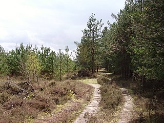
Bramshill is a 673.3-hectare (1,664-acre) biological Site of Special Scientific Interest near Bramshill, northeast of Basingstoke in Hampshire. It is part of Thames Basin Heaths Special Protection Area for the conservation of wild birds.

Eelmoor Marsh is a 66.3-hectare (164-acre) biological Site of Special Scientific Interest between Fleet and Farnborough in Hampshire. It is part of Thames Basin Heaths Special Protection Area for the conservation of wild birds.

Hurst Castle and Lymington River Estuary is a 1,077.3-hectare (2,662-acre) biological and geological Site of Special Scientific Interest near Lymington in Hampshire. It is a Nature Conservation Review site and two areas are Geological Conservation Review sites. Three areas are local nature reserves, Boldre Foreshore, Sturt Pond and Lymington and Keyhaven Marshes; the latter site is managed by the Hampshire and Isle of Wight Wildlife Trust. Part of it is North Solent National Nature Reserve. It is part of Solent and Southampton Water Ramsar site and Special Protection Area. Parts of it are in Solent Maritime and Solent and Isle of Wight Lagoons Special Areas of Conservation.

Lymington River SSSI is a 34.8-hectare (86-acre) biological and geological Site of Special Scientific Interest along Lymington River and its tributaries between Lymington, Burley and Stoney Cross in Hampshire. HIghland Water is a Geological Conservation Review site and Ober Water is a Nature Conservation Review site, Grade I. Parts of the site are in The New Forest and Solent and Southampton Water Ramsar sites, and in The New Forest Special Protection Area.

Porton Down SSSI is a 1,559-hectare (3,850-acre) biological Site of Special Scientific Interest which spans the border between Hampshire and Wiltshire in England. It is adjacent to Porton Down science park near Porton, and much of it is Ministry of Defence property which is closed to the public. It is a Nature Conservation Review site, Grade I, a Special Area of Conservation and a Special Protection Area.

Roydon Woods is a 294.9-hectare (729-acre) biological Site of Special Scientific Interest near Brockenhurst in Hampshire. It is a nature reserve managed by the Hampshire and Isle of Wight Wildlife Trust and is part of New Forest Special Area of Conservation.

Hockley Meadows is a 9-hectare (22-acre) nature reserve south of Winchester in Hampshire. It is managed by the Hampshire and Isle of Wight Wildlife Trust. It is part of the River Itchen SSSI and Special Area of Conservation.

Lashford Lane Fen is a 7-hectare (17-acre) nature reserve north of Dry Sandford in Oxfordshire. It is managed by the Berkshire, Buckinghamshire and Oxfordshire Wildlife Trust. It is part of Cothill Fen, which is a Site of Special Scientific Interest and Special Area of Conservation.
