
Brimpton Pit is a 1.6-hectare (4.0-acre) geological Site of Special Scientific Interest west of Aldermaston in Berkshire. It is a Geological Conservation Review site.

Westwood Quarry is a 0.07 hectare geological site of Special Scientific Interest west of Watford in Hertfordshire. It was notified in 1987 under the Wildlife and Countryside Act 1981. The planning authority is Three Rivers District Council. It is a Geological Conservation Review site.

Cannoncourt Farm Pit is a 0.3-hectare (0.74-acre) geological Site of Special Scientific Interest in Maidenhead in Berkshire. It is a Geological Conservation Review site.

Moor Mill Quarry, West is a 0.16 hectare geological Site of Special Scientific Interest in How Wood in Hertfordshire. The local planning authority is St Albans City and District Council. It was notified in 1992 as representing the former Moor Mill Quarry SSSI, which was lost to landfill operations. It is listed by the Geological Conservation Review.

Downfield Pit is a 3.6 hectare geological Site of Special Scientific Interest near Ware in Hertfordshire. It is in the Geological Conservation Review in the Thames Pleistocene section, and the local planning authority is East Hertfordshire District Council.

Fern House Gravel Pit is a 1.3 hectare geological Site of Special Scientific Interest in Fern, near Bourne End in Buckinghamshire. It is also a Geological Conservation Review site.

Highlands Farm Pit is a 0.6 hectare geological Site of Special Scientific Interest in Henley-on-Thames in Oxfordshire. It is a Geological Conservation Review site.

Holland-on-Sea Cliff is a 0.1 hectare geological Site of Special Scientific Interest in Holland-on-Sea, north-west of Clacton-on-Sea in Essex. It is a Geological Conservation Review site.
St Osyth Pit is a 0.1 hectare geological Site of Special Scientific Interest north of St Osyth in Essex. It is a Geological Conservation Review site.

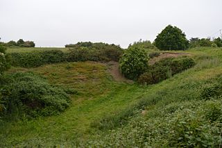
Hamstead Marshall Pit is a 0.2-hectare (0.49-acre) geological Site of Special Scientific Interest north of Hamstead Marshall in Berkshire. It is a Geological Conservation Review site.

Aylesford Pit is a 1.5-hectare (3.7-acre) geological Site of Special Scientific Interest north of Maidstone in Kent. It is a Geological Conservation Review site.

Dry Sandford Pit is a 4.2-hectare (10-acre) biological and geological Site of Special Scientific Interest north-west of Abingdon-on-Thames in Oxfordshire. It is a Geological Conservation Review site and it is managed as a nature reserve by the Berkshire, Buckinghamshire and Oxfordshire Wildlife Trust.

Kirtlington Quarry is a 3.1-hectare (7.7-acre) geological Site of Special Scientific Interest west of Kirtlington in Oxfordshire. It is a Geological Conservation Review site, and it is part of the 7.4-hectare (18-acre) Kirtlington Quarry Local Nature Reserve.

Woodeaton Quarry is a 7.3-hectare (18-acre) geological Site of Special Scientific Interest north of Oxford in Oxfordshire. It is a Geological Conservation Review site.

Cothill Fen is a 43.3-hectare (107-acre) biological and geological Site of Special Scientific Interest north-west of Abingdon-on-Thames in Oxfordshire. It is a Special Area of Conservation and parts of it are a Geological Conservation Review, site, a Nature Conservation Review site, Grade 1, and a National Nature Reserve. It also includes two areas which are nature reserves managed by the Berkshire, Buckinghamshire and Oxfordshire Wildlife Trust, Lashford Lane Fen and Parsonage Moor.
Pixey and Yarnton Meads is a 86.4-hectare (213-acre) biological Site of Special Scientific Interest north of Oxford in Oxfordshire. It is a Nature Conservation Review site, Grade I, and part of Oxford Meadows Special Area of Conservation.

Port Meadow with Wolvercote Common and Green is a 167.1-hectare (413-acre) biological Site of Special Scientific Interest in Oxford in Oxfordshire. It is a Nature Conservation Review site, Grade I, and part of Oxford Meadows Special Area of Conservation. The remains of Godstow Abbey, which is a Scheduled Monument, are in the north of the site.

Ardley Trackways is a 63.6-hectare (157-acre) geological Site of Special Scientific Interest north-west of Bicester in Oxfordshire. It is a Geological Conservation Review site.
