
Wytham is a village and civil parish on the Seacourt Stream, a branch of the River Thames, about 3 miles (5 km) northwest of the centre of Oxford. It is just west of the Western By-Pass Road, part of the Oxford Ring Road (A34). The nearest village is Godstow. Wytham was the northernmost part of Berkshire until the 1974 boundary changes transferred it to Oxfordshire.

Wytham Abbey is a privately-owned Grade I listed historic manor house situated in the village of Wytham, 3 miles northwest of the centre of Oxford, England, near the River Thames.
Bix Bottom is a 102.3-hectare (253-acre) biological Site of Special Scientific Interest north-west of Henley-on-Thames in Oxfordshire. It is owned and managed as Warburg Nature Reserve by the Berkshire, Buckinghamshire and Oxfordshire Wildlife Trust.

Lesnes Abbey Woods, sometimes known as Abbey Wood, is a 73-hectare ancient woodland in southeast London, England. It is located near to, and named after, the ruined Lesnes Abbey in the London Borough of Bexley and gives its name to the Abbey Wood district. The woods are adjacent to the 159-ha Bostall Woods.

Lye Valley is a 2.3-hectare (5.7-acre) biological Site of Special Scientific Interest in Headington, a suburb of Oxford in Oxfordshire. It is part of the 4.5-hectare (11-acre) Lye Valley Local Nature Reserve, which is owned and managed by Oxford City Council.

Bentley Priory Nature Reserve is a Site of Special Scientific Interest and Local Nature Reserve in Stanmore in the London Borough of Harrow, surrounding the stately home of Bentley Priory. It is a 55 hectare mosaic of ancient woodland, unimproved neutral grassland, scrub, wetland, streams and an artificial lake, an unusual combination of habitats in Greater London.

Abbey Wood is a 6.3-hectare (16-acre) geological Site of Special Scientific Interest in Abbey Wood in the London Borough of Bexley. It is located in Lesnes Abbey Woods south-east of the ruins of Lesnes Abbey. Members of the public can dig for fossils in a small area designated as the Fossil Bed with the permission of the Lesnes Abbey ranger.

Frilford Heath, Ponds and Fens is a 108.8-hectare (269-acre) biological Site of Special Scientific Interest in Frilford, west of Abingdon in Oxfordshire. An area of 3 hectares, separate from the main site is Hitchcopse Pit, a nature reserve managed by the Berkshire, Buckinghamshire and Oxfordshire Wildlife Trust.

West Blean and Thornden Woods is a 781-hectare (1,930-acre) biological Site of Special Scientific Interest north of Canterbury in Kent. It is part of the Blean Woods Nature Conservation Review site, and an area of 490 hectares is a nature reserve managed by the Kent Wildlife Trust. The woods form one of the largest areas of ancient woodland in the UK, with parts of it over 1,000 years old.

Brasenose Wood and Shotover Hill is a 109.2-hectare (270-acre) biological Site of Special Scientific Interest on the eastern outskirts of Oxford in Oxfordshire. It is a Nature Conservation Review site.

Waterperry Wood is a 137-hectare (340-acre) biological Site of Special Scientific Interest (SSSI) east of Oxford in Oxfordshire. It is a Nature Conservation Review site, Grade I, and is owned and managed by the Forestry Commission.
Whitecross Green and Oriel Woods is a 63-hectare (160-acre) biological Site of Special Scientific Interest between Oxford and Bicester in Oxfordshire. It is owned and managed by the Berkshire, Buckinghamshire and Oxfordshire Wildlife Trust under the name Whitecross Green Wood.

Ardley Cutting and Quarry is a 40.1-hectare (99-acre) biological and geological Site of Special Scientific Interest north-west of Bicester in Oxfordshire. It is a Geological Conservation Review site and an area of 11 hectares is managed by the Berkshire, Buckinghamshire and Oxfordshire Wildlife Trust as Ardley Wood Quarry. The site contains a Scheduled Monument, Ardley Wood moated ringwork, a Norman defended enclosure.

Cothill Fen is a 43.3-hectare (107-acre) biological and geological Site of Special Scientific Interest north-west of Abingdon-on-Thames in Oxfordshire. It is a Special Area of Conservation and parts of it are a Geological Conservation Review site, a Nature Conservation Review site, Grade 1, and a National Nature Reserve. It also includes two areas which are nature reserves managed by the Berkshire, Buckinghamshire and Oxfordshire Wildlife Trust, Lashford Lane Fen and Parsonage Moor.

Port Meadow with Wolvercote Common and Green is a 167.1-hectare (413-acre) biological Site of Special Scientific Interest in Oxford in Oxfordshire. It is a Nature Conservation Review site, Grade I, and part of Oxford Meadows Special Area of Conservation. The remains of Godstow Abbey, which is a Scheduled Monument, are in the north of the site.

Butter Wood is a 133-hectare (330-acre) biological Site of Special Scientific Interest (SSSI) east of Basingstoke in Hampshire. Part of Up Nately LNR, which is designated a Local Nature Reserve, is in the SSSI.

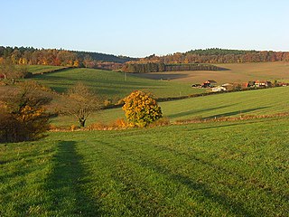
Wytham Ditches and Flushes is a 2.7-hectare (6.7-acre) biological Site of Special Scientific Interest north of Oxford in Oxfordshire.
