
Sheepleas is a 99.9-hectare (247-acre) biological and geological Site of Special Scientific Interest east of Guildford in Surrey. It is a Geological Conservation Review site and a Local Nature Reserve. It is owned by Surrey County Council and managed by the Surrey Wildlife Trust.

Dryhill is an 11.7-hectare (29-acre) geological Site of Special Scientific Interest on the western outskirts of Sevenoaks in Kent. It is a Geological Conservation Review site, and an area of 9.5 hectares is a Local Nature Reserve
Sandwich Bay to Hacklinge Marshes is a 1,790.1-hectare (4,423-acre) biological and geological Site of Special Scientific Interest which stretches between Deal and Sandwich in Kent. It includes two Geological Conservation Review sites, and most of it is a Nature Conservation Review site, Grade I. Part of it is a Ramsar site, a Special Area of Conservation, a Special Protection Area and a National Nature Reserve, It also includes a Kent Wildlife Trust nature reserve and a Local Nature Reserve,
Thanet Coast is an 816.9-hectare (2,019-acre) biological and geological Site of Special Scientific Interest which stretches along the coast between Whitstable and Ramsgate in Kent. It is a Geological Conservation Review site, and overlaps two Special Area of Conservations. It is also part of a Ramsar Site and a Special Protection Area. Part of it is a Local Nature Reserve,
Stanford Training Area SSSI is part of the British Army Stanford Training Area. It is a 4,678-hectare (11,560-acre) biological and geological Site of Special Scientific Interest north of Thetford in Norfolk. It is a Nature Conservation Review site and part of it is a Geological Conservation Review site. It is also part of the Breckland Special Area of Conservation and Special Protection Area.
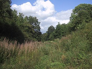
Hook Norton Cutting and Banks is a 6.7-hectare (17-acre) biological and geological Site of Special Scientific Interest south of Hook Norton in Oxfordshire. The site is in three areas, two of which are managed as a nature reserve called Hook Norton Cutting by Berkshire, Buckinghamshire and Oxfordshire Wildlife Trust. and are designated a Geological Conservation Review site.

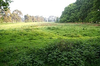
Kirtlington Quarry is a 3.1-hectare (7.7-acre) geological Site of Special Scientific Interest west of Kirtlington in Oxfordshire. It is a Geological Conservation Review site, and it is part of the 7.4-hectare (18-acre) Kirtlington Quarry Local Nature Reserve.

Cothill Fen is a 43.3-hectare (107-acre) biological and geological Site of Special Scientific Interest north-west of Abingdon-on-Thames in Oxfordshire. It is a Special Area of Conservation and parts of it are a Geological Conservation Review site, a Nature Conservation Review site, Grade 1, and a National Nature Reserve. It also includes two areas which are nature reserves managed by the Berkshire, Buckinghamshire and Oxfordshire Wildlife Trust, Lashford Lane Fen and Parsonage Moor.

Butter Wood is a 133-hectare (330-acre) biological Site of Special Scientific Interest (SSSI) east of Basingstoke in Hampshire. Part of Up Nately LNR, which is designated a Local Nature Reserve, is in the SSSI.

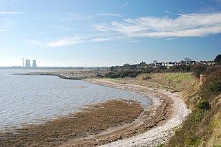
Hurst Castle and Lymington River Estuary is a 1,077.3-hectare (2,662-acre) biological and geological Site of Special Scientific Interest near Lymington in Hampshire. It is a Nature Conservation Review site and two areas are Geological Conservation Review sites. Three areas are local nature reserves, Boldre Foreshore, Sturt Pond and Lymington and Keyhaven Marshes; the latter site is managed by the Hampshire and Isle of Wight Wildlife Trust. Part of it is North Solent National Nature Reserve. It is part of Solent and Southampton Water Ramsar site and Special Protection Area. Parts of it are in Solent Maritime and Solent and Isle of Wight Lagoons Special Areas of Conservation.

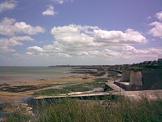
Lee-on-The Solent to Itchen Estuary is a 585.9-hectare (1,448-acre) biological and geological Site of Special Scientific Interest which stretches along the coast between Southampton and Gosport in Hampshire. It is a Geological Conservation Review site. It is part of Solent and Southampton Water Ramsar site and Special Protection Area, and of Solent Maritime Special Area of Conservation. Three areas are Local Nature Reserves, Chessel Bay, Hook with Warsash and Mercury Marshes. One area is Hamble Common Camp, a Scheduled Monument.

North Solent is a 1,186.7-hectare (2,932-acre) biological and geological Site of Special Scientific Interest along the north bank of the Solent between East End and Calshot in Hampshire. It is a Nature Conservation Review site, Grade I. Part of it is in North Solent National Nature Reserve and two areas are Geological Conservation Review sites. It is part of Solent and Southampton Water Ramsar site and Special Protection Area, and of Solent Maritime Special Area of Conservation. Boldre Foreshore is a local nature reserve.

Wealden Edge Hangers is a 222.4-hectare (550-acre) biological Site of Special Scientific Interest north of Petersfield in Hampshire. An area of 48 hectares is Wealden Edge Hangers Local Nature Reserve and an area of 144.1 hectares is Ashford Hangers National Nature Reserve. Wealden Edge Hangers is part of the East Hampshire Hangers Special Area of Conservation.
