Mahabaleshwar is a small town and a municipal council in Satara district, Maharashtra, India. It is a place of pilgrimage for Hindus because the Krishna river has its origin here. The British colonial rulers developed the town as a hill station, and served as the summer capital of Bombay Presidency during the British Raj.
Satara is a city located in the Satara District of Maharashtra state of India, near the confluence of the river Krishna and its tributary, the Venna. The city was established in the 16th century and was the seat of the Chhatrapati of Maratha Empire, Shahu I.

Roha is a town and taluka in the Raigad district of the Maharashtra state of India. It is located 120 km southeast of Mumbai. It is the starting point of Konkan railways and end point of central railways (Mumbai). Many chemical industries have opened up their manufacturing bases in Roha. Roha is located between the banks of the Kundalika River and the hills of Kalasgiri. It has a population of over 20,849. Roha is connected to Mumbai by Panvel-Roha railway line. Roha is also the northern end of the Konkan Railway. Roha is off of the Mumbai Goa Highway, via the Kolad road.
Wai is a town in Satara district of Maharashtra state in India. Located on the Krishna River, Wai was a prominent town during the Peshwa era. Two important Marathi Brahmin from ruling families had their origins here: Rani Lakshmibai of Jhansi and Gopikabai, wife of Nanasaheb Peshwa.

Satara district is a district of Maharashtra state in western India with an area of 10,480 km2 (4,050 sq mi) and a population of 3,003,741 of which 14.17% were urban. Satara is the capital of the district and other major towns include Medha, Wai, Karad, Malkapur, Koregaon, Rahimatpur, Dahiwadi, Koynanagar, Phaltan, Lonand, Mahabaleshwar, Panchgani, Vaduj and Mhaswad. This district comes under Pune Administrative Division along with Pune, Sangli, Solapur and Kolhapur. The district of Pune bounds it to the north, Raigad bounds it to the north-west, Solapur the east, Sangli to the south, and Ratnagiri to the west.

Chiplun ( [t͡ʃipɭuːɳ]) is a city in Ratnagiri district in the state of Maharashtra, India. It is one of the financial and commercial Hubs of Ratnagiri district, and the headquarters of Chiplun taluka. It is about 250 km south of Mumbai and 90 km North of Ratnagiri in the Konkan region of Maharashtra, on the Mumbai–Goa highway (NH-66). It has a long history and a strong cultural background. Recent decades have seen much industrial development in it and its and surrounding areas.
Daund is a city, municipal council, and headquarters of the Daund tehsil in the Pune district in the state of Maharashtra, India. The city of Daund is located on the Bhima River.
Gadhinglaj ([ɡəɖᵊɦiŋɡləd͡z]) is a city in India in the Kolhapur district in the southwest corner of the state of Maharashtra, India. It is located on the banks of the river Hiranyakeshi. It is the Taluka (Tehsil) headquarters of Gadhinglaj Taluka and a subdivision headquarters of the Gadhinglaj Subdivision of the Kolhapur District. It is governed by a municipal council. The rapidly growing city is the third largest in the Kolhapur District, with population of more than 50,000. Places to visit like Samagad fort, temples and beautiful weather.
Indapur is a town and a municipal council in Pune district in the Indian state of Maharashtra. Indapur is known for Jahagir of Chhatrapati Shivaji Maharaj's father and grandfather. Chhatrapati Shivaji Maharaj's grandfather Malojiraje died in battle in Indapur.
Manchar is a census town and Nagar panchayat in Ambegaon taluka of Pune district in the Indian state of Maharashtra. Nearby villages are Kalamb, Pimpalgoan, and Landewadi. It is governed by Manchar Nagar Panchayat which is second Nagar panchayat in the Pune district.
Murbad is a census town within the administrative division (taluka) of Thane district in the Indian state of Maharashtra. Murbad city with its neighbouring villages jointly form the Murbad nagar panchayat, which is near the cities of Thane, Karjat and Kalyan. Nearby cities include Badlapur, Ambernath, Ulhasnagar, and Dombivli. It is a largely industrial town with private and public enterprises (MIDC).
Shirur is an administrative subdivision of the Pune district in the Indian state of Maharashtra. It is located on the eastern boundary of the district, on the banks of the Ghod River. The town is also called Ghodnadi to distinguish it from other locations that have the same name. Ghodnadi in Marathi Language means Ghod River.
Parola is a city and a municipal council in Jalgaon district in the Indian state of Maharashtra. It is located on the Hajira (Surat)–Dhule–Kolkata national highway 6. The municipal council was established by the British government before the independence of India. This City is centuries old known for the two main features such as the Shree Balaji Temple and The Parola fort Also known as the native of Rani Laxmibai of Jhansi.
Chakan is a census town in India, in Pune district of the Indian state of Maharashtra. While agriculture remains an important factor, the town's industrial development is quickly urbanizing the area. The Independent referred Chakan as India's "Motor City".
Vasind is a city in Shahapur taluka of Thane district in the Indian state of Maharashtra. It is suburban city of Mumbai.Mumbai-Vasind distance is about 63.1 km. Vashind is a census town.
Khandala is a town and taluka in the Satara district in the Indian state of Maharashtra.
Wagholi is a village in Koregaon takula of Satara district of Maharashtra, India. It plays an important role in the economic, social, cultural, and educational lives of people in Koregaon, and Satara Districts.

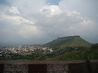
Ninam is a census village in Satara district, in the Indian state of Maharashtra. It is a village surrounded by greenery and farms but also mountains. Agriculture is the main land use in the village with more than 75% of the total area being used for agricultural activities. The village close to historic Ajinkyatara fort, which is to the north. The large Jyotirlinga temple is in the center of the village.

Vaduj is a major town in Satara district of Maharashtra, India. It is the headquarters of Khatav Taluka. It is located on the banks of the Yerala River, and is around 58 kilometres (36 mi) away from the district capital Satara, and 165 kilometres (103 mi) away from Pune. It is the biggest town in Khatav Taluka, with a population of around 17,636 people. Recently, its status was changed to Nagar Panchayat.

Vele is a village in the Western region of Maharashtra state in India. It is located in Satara district of Maharashtra. Before it was a part of Bombay State and Princely state of Satara. It is located adjacent to Kanher Dam built on Venna River. There is a big temple of Bhairava at the village entrance. Also there are number of temples in closed vicinity of village. Surrounded by greenery and farms, agriculture is the main occupation in the village with more than 80% of the total area being used for agricultural activities. Though agriculture constitutes a mainstay of the economy of this village, besides a sizeable population working at various plum government positions does bolster the financial position.

